MAPS OF HISTORY · WW2 · MAPS BY YEAR · May 1945The War Room — WW2, 1936–1945 · THE MAP IN MAY 1945
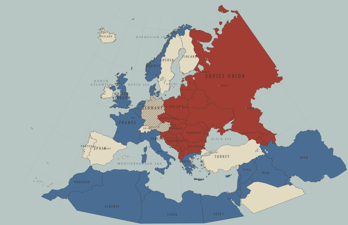
Map of Europe in May 1945
Victory in Europe · WW2
Europe in May 1945: Victory in Europe. Since January 1945, 16 territories changed status on this map: including Germany, East Prussia, Austria and 13 more.
MAY 1945 · THE WAR ROOM — WW2, 1936–1945 These maps are reconstructed from published sources · Allied governments — zones of occupation and administration of Greater Berlin, 26 July 1945 · Cliopatria v0.2.1 — dated political boundaries · Regional history institute — Italian annexations of1941, Fiume province and Krk · Regional history institute — Morgan Line and Pola enclave,1945–1947 · IGM Fiume, 1:25,000, sheet53B II SE — boundary established in1924 · Natural Earth — physical reference geography · Yugoslavia (1929–1939) location map — international frontier and Adriatic coast · Treaty of Rome (1924), division of Fiume and west-bank boundary · National Museum of Contemporary History of Slovenia — Allied/Yugoslav presence and Morgan demarcation
Source details Allied governments, 1945 protocol. Historical administrative facts consulted Cliopatria contributors / Seshat Global History Databank. CC BY4.0 · Dated polity and constituent territory selections; campaign-dependent occupation overlays reconstructed separately. Regional history institute — Italian annexations of1941, Fiume province and Krk. Historical geographic facts consulted; source prose and artwork not republished Istituto regionale per la storia della Resistenza e dell’Età contemporanea nel Friuli Venezia Giulia. Independent geographic-fact reconstruction; original artwork not distributed Istituto Geografico Militare, Fiume (printed1946; 1927 survey with1931–1940 updates), reproduced by Istituto regionale per la storia della Resistenza e dell’Età contemporanea nel Friuli Venezia Giulia. Independent reconstruction from graticule coordinates and boundary observations; archive page reserves artwork rights.. Geographical-fact reconstruction; original archive artwork not distributed Natural Earth. Public domain NordNordWest/Wikipedia. Converted from the published SVG to WGS84; eastern Italian regional territory extracted. Source cites Velhagen & Klasings Großer Volksatlas (1938).. CC BY-SA 3.0 Germany 1924 agreement interpreted alongside the regional history institute and City of Rijeka’s explanation of the Donja/Gornja Drenova division.. Historical geographic facts; citation only National Museum of Contemporary History of Slovenia — Allied/Yugoslav presence and Morgan demarcation. Historical geographic facts consulted; source prose and artwork not republished The earliest separately published East and West German outlines serve as regional geometry proxies for the German occupation zones. Berlin sector detail lies beyond the source’s resolution.
The June 1945 Morgan military demarcation and the separate Pola enclave are reconstructed from the published map. They show occupation areas, not a settlement of sovereignty. For May 1945, the June line is the closest acquired geographic reference for the western Allied presence, including the joint presence at Trieste. Pola remains Yugoslav-held until June. The map does not assert an exclusive military boundary for May.
proxy: 1949–1952East /1950–1957West regional reference · proxy: Earliest separateBerlin enclave in1949 source;1945occupation chronology · reconstruction: 1945.36 · reconstruction: 1945–1945 · reconstruction: 1945–1957 · reconstruction: 1945–2023 · reconstruction: 1949–1952East /1950–1957West regional reference · vector: 1912–1955 · vector: 1936–1945 · vector: 1938–1972 · vector: 1939–2023 · vector: 1942–1945 · vector: 1943–1945 · vector: 1943–1946 · vector: 1944–1945 · vector: 1945–1945 · vector: 1945–2023
Layer records and reconstruction methods
What changes on the map
Related maps
◧ EMBED THIS MAP ON YOUR SITE
You may embed this map free if you keep the attribution link. Teachers can find print-ready
study guides at /study/ .
THE FREE PRINTABLE STUDY GUIDE
Get the printable study guide for WW2 free. I’ll send you a few short letters, then one when a new atlas opens. That’s all. — Paul
NO TRACKING · YOUR ADDRESS IS USED FOR THE DISPATCH AND NOTHING ELSE ·
UNSUBSCRIBE ANYTIME