METHOD
How these maps are made
Each chapter links to the published maps, datasets and historical references used to reconstruct its geography. You can follow those links to see the direct sources behind the borders on the map.
Trace a map to its sources
- Original references. Follow the links at the bottom of each chapter to the published maps, geographic datasets and historical evidence behind the map.
- Dates and coverage. Read which period and territory each source represents. Where the closest available source comes from a different date, the layer record explains that choice.
- Reconstruction methods. See whether an outline was imported from geographic data, traced from a published map or reconstructed from cited evidence. Source limitations and adjustments are recorded.
- Credits and reuse terms. Find the creator, version and licence, together with available downloads of the geometry used.
- Questions and corrections. Share the atlas, chapter and reference with paul@mapsofhistory.com so we can investigate.
Browse the source list for every atlas ↓
THE BASE MAP
The physical and administrative reference geography comes from Natural Earth, which is public domain. Historical layers draw on dated vector datasets, documented reconstructions and geographic information from published historical maps. The source record for each layer says which method was used; a modern reference is not presented as a period survey.
DATED GEOGRAPHY
Choose a chapter or a point on the timeline, and the geography changes with it. Historical unions, territorial divisions and occupation areas have their own source records instead of being forced into today’s country borders. When an exact dated outline is unavailable, we use the closest suitable published geography or reconstruct it from cited evidence. The source details give the reference date and any material difference from the chapter.
HOW SOURCES ARE CHECKED
A downloaded source still needs to be checked. We examine its version, reuse terms, date and territorial meaning, then check named locations inside or outside the selected outline. Limitations and corrections are recorded alongside the geometry. Islands and holes are kept, and the tolerance for any display optimisation is recorded. Readers can use the source links and reconstruction records to inspect these choices and raise questions about them.
A military front does not describe the same thing as a political boundary; an administrative reporting region and a schematic route have different meanings again. The source records keep these distinctions. The timeline’s territory graphic counts overlapping areas once to measure a share of the displayed map; it is not an equal-area geographic statistic.
Map sources by atlas
The lists below show the published sources used for each atlas. Chapter notes identify the references behind the map you are viewing; the full layer records give dates, methods and source-specific limitations. The evidence for a reconstruction may include the closest suitable published geography when an exact dated outline is unavailable.
The Rise and Fall of Rome, 264 BC – AD 476 · 13 sources
Browse the chapters and their source notes · Full layer records and reconstruction methods
- Cliopatria v0.2.1 — Cliopatria contributors / Seshat Global History Databank. Selected, combined, and reprojected by Maps of History; dated adjustments are recorded per layer.. CC BY 4.0.
- Natural Earth physical coastlines and rivers — Made with Natural Earth. Modern physical geography is a coastline/river reference, not evidence of ancient sovereignty.. Public domain.
- Pleiades: ancient places and Hadrian’s Wall forts — Pleiades contributors; A. S. Esmonde Cleary, R. Talbert and subsequent editors (individual record credits retained in the review). Wall route reconstructed through published fort locations.. CC BY 3.0.
- Polybius, Histories 1: Sicily and the First Punic War — Polybius, Histories, book 1 (Perseus).. Historical evidence citation; no prose or map copied.
- Polybius, Histories 3: Hannibal’s campaign — Polybius, Histories, book 3 (Perseus).. Historical evidence citation; no prose or map copied.
- The Metropolitan Museum: The Roman Republic — Department of Greek and Roman Art, The Metropolitan Museum of Art (2000).. Historical evidence citation; no prose or map copied.
- The Metropolitan Museum: Palmyra — Department of Ancient Near Eastern Art, The Metropolitan Museum of Art (2000).. Historical evidence citation; no prose or map copied.
- Egypt Ministry of Tourism and Antiquities: Roman Period — Egypt Ministry of Tourism and Antiquities: beginning of Roman administration, 30 BC.. Historical evidence citation; no prose or map copied.
- UNESCO: Frontiers of the Roman Empire — UNESCO World Heritage Centre: frontier-system identification and dates.. Historical evidence citation; no map copied.
- English Heritage: Hadrian’s Wall facts and FAQs — English Heritage, facts checked by Dr Frances McIntosh (2026): wall endpoints and fort sequence.. Historical evidence citation; no copyrighted map traced.
- Procopius, History of the Wars, V.1: Odoacer and Italy — Procopius, Wars V.1 (public-domain H. B. Dewing translation).. Historical evidence citation; no prose or map copied.
- Ancient World Mapping Center: Dacia from the AD 200 province and empire boundary layers — Ancient World Mapping Center, UNC-Chapel Hill; derived from the Barrington Atlas and AWMC modifications to OpenStreetMap. Dacia polygon assembled by Maps of History from the published boundary lines; derivative distributed under ODbL 1.0.. ODbL 1.0.
- UNESCO: Frontiers of the Roman Empire – Dacia — UNESCO World Heritage Centre: province north of the Danube, operational 106–271 CE; Transylvanian plateau and Olt frontier.. Historical evidence citation; no map copied.
Climate and Innovation: The Norse and the Aztecs, c. 790–1521 · 22 sources
Browse the chapters and their source notes · Full layer records and reconstruction methods
- Natural Earth v5.1.2 full geographic reference — Natural Earth contributors. Public domain.
- Natural Earth administrative references — Natural Earth contributors. Public domain.
- Cliopatria v0.2.1 historical polities — Cliopatria contributors / Seshat Global History Databank. CC BY 4.0.
- Basin of Mexico, c.1519 — published lake and causeway map — Yavidaxiu, Historicair, Sémhur and named Commons contributors. CC BY-SA 4.0.
- Hanns Prem: Tenochtitlan and islands in Texcoco Lake, 2008 — Hanns Prem. Public domain dedication by the author (PD-self), worldwide reuse for any purpose.
- Mexico Secretariat of Culture / INAH: Tlatelolco archaeological-site location — Mexico Secretariat of Culture / INAH: Tlatelolco archaeological-site location. Historical facts cited; no source artwork or prose reproduced.
- Aztec tribute provinces, 1519 — published vector map — Yavidaxiu, Ssolbergj, Keepscases and Sémhur. CC BY-SA 3.0.
- Norse Eastern Settlement: named farm distribution — Masae, based on Arneborg, Gulløv and Guðmundsson. CC BY-SA 3.0.
- Norse Western Settlement: farm distribution — Masae, based on Arneborg, Gulløv and Guðmundsson. CC BY-SA 3.0.
- GeoNames geographic controls — GeoNames contributors. CC BY 4.0.
- Greenland National Museum: Anavik archaeological survey, p.11 — Greenland National Museum: Anavik archaeological survey, p.11. Historical facts cited; no source artwork or prose reproduced.
- Hollesen et al.2016: Sandnes site coordinates — Jørgen Hollesen and coauthors. CC BY 4.0.
- UNESCO: Kujataa archaeological landscape — UNESCO: Kujataa archaeological landscape. Historical facts cited; no source artwork or prose reproduced.
- Ljungqvist 2005: Norðrsetur and Disko Bay hunting — Ljungqvist 2005: Norðrsetur and Disko Bay hunting. Historical facts cited; no source artwork or prose reproduced.
- Friesen and Arnold 2008: timing of the Thule migration — Friesen and Arnold 2008: timing of the Thule migration. Historical facts cited; no source artwork or prose reproduced.
- Sámi Parliament: the Sápmi homeland — Sámi Parliament: the Sápmi homeland. Historical facts cited; no source artwork or prose reproduced.
- Parks Canada: L’Anse aux Meadows and the Vinland sagas — Parks Canada: L’Anse aux Meadows and the Vinland sagas. Historical facts cited; no source artwork or prose reproduced.
- Ogilvie et al.2009: seals and sea ice in Norse Greenland — Ogilvie et al.2009: seals and sea ice in Norse Greenland. Historical facts cited; no source artwork or prose reproduced.
- Rio Verde Archaeology: independent Tututepec — Rio Verde Archaeology: independent Tututepec. Historical facts cited; no source artwork or prose reproduced.
- García Quintana and Romero Galván: Tenochtitlan waterworks — García Quintana and Romero Galván: Tenochtitlan waterworks. Historical facts cited; no source artwork or prose reproduced.
- Territorial division in the Alfred–Guðrum treaty — Territorial division in the Alfred–Guðrum treaty. Historical facts cited; no source artwork or prose reproduced.
- Cliopatria source periods for Normandy — Cliopatria contributors. CC BY 4.0.


The Crusades, 1095–1291 · 10 sources
Browse the chapters and their source notes · Full layer records and reconstruction methods
- Cliopatria v0.2.1 — historical political boundaries — Cliopatria contributors / Seshat Global History Databank. CC BY 4.0.
- The Metropolitan Museum of Art — The Crusades (1095–1291) — Department of Medieval Art and The Cloisters, 2014. Facts consulted; no prose or image copied.
- The Metropolitan Museum of Art — Byzantium (ca. 330–1453) — The Metropolitan Museum of Art. Facts consulted; no prose or image copied.
- Reuven Amitai-Preiss — Mongols and Mamluks — Reuven Amitai-Preiss, Cambridge University Press,1995. Historical event chronology consulted; no map or prose copied.
- Cambridge University Library — A Fatimid Interoffice Memo about the Franks — Marina Rustow, Alan Elbaum and Paul M. Cobb, 2026. Facts consulted; no image or prose copied.
- Simon Barton — Crusading in Iberia, c. 1060–1212 — Simon Barton, The Cambridge History of the Crusades. Published summary consulted for dated conquests; no map copied.
- Israeli Institute of Archaeology — The Crusader Period — Israeli Institute of Archaeology. Facts consulted; local treaty corridor independently reconstructed.
- Steven Runciman — The Kingdom of Acre and the Later Crusades, Frederick II — Steven Runciman, A History of the Crusades, volume III. Named places and treaty terms consulted; no prose or map copied.
- OpenStax — The Crusading Movement — OpenStax, World History Volume 1. CC BY 4.0.
- Natural Earth — physical reference geography — Natural Earth. Public domain.
The Mongol Empire, 1206–1294 · 15 sources
Browse the chapters and their source notes · Full layer records and reconstruction methods
- Cliopatria v0.2.1 — historical political boundaries — Cliopatria contributors / Seshat Global History Databank. CC BY 4.0.
- Asia for Educators, Columbia University — Three Invasions Led by Chinggis — Asia for Educators, Columbia University. Text consulted for historical facts; no map or prose copied.
- Asia for Educators — Expansion under Ögödei — Asia for Educators, Columbia University. Text consulted for historical facts; no map or prose copied.
- Asia for Educators — Collapse of the Empire and Four Sectors — Asia for Educators, Columbia University. Text consulted for historical facts; no map or prose copied.
- Asia for Educators — Military Successes and Failures — Asia for Educators, Columbia University. Text consulted for historical facts; no map or prose copied.
- Peter Jackson, Encyclopaedia Iranica — Mongols — Peter Jackson / Encyclopaedia Iranica. Historical facts consulted; thematic geometry independently reconstructed.
- Encyclopaedia Iranica — Herat, medieval history — Encyclopaedia Iranica. Historical facts consulted; thematic geometry independently reconstructed.
- The Metropolitan Museum of Art — The Legacy of Genghis Khan — Qamar Adamjee and Stefano Carboni, 2003. Historical facts consulted; no image or prose copied.
- Büntgen and Di Cosmo (2016), Mongol withdrawal from Hungary — Ulf Büntgen and Nicola Di Cosmo. CC BY 4.0.
- Institute of History of Ukraine — Mongol invasion and its consequences — Encyclopedia of the History of Ukraine, 2019. Historical facts consulted; thematic geometry independently reconstructed.
- Janet Martin — Medieval Russia 980–1584, chronology — Janet Martin, Cambridge University Press. Historical facts consulted; no map or prose copied.
- Fudan historical gazetteer — Xiangyang circuit, 1273–1363 — Fudan University / CHGIS historical gazetteer. Historical chronology consulted; no CHGIS boundary dataset imported.
- ISEAS Nalanda-Sriwijaya Centre Working Paper 25 — Mongol campaigns — ISEAS–Yusof Ishak Institute. Historical facts consulted; no map or prose copied.
- Reuven Amitai-Preiss — Mongols and Mamluks, chapter 2 — Reuven Amitai-Preiss, Cambridge University Press, 1995. Historical facts consulted; no map or prose copied.
- Natural Earth — physical reference geography — Natural Earth. Public domain.
The Industrial Revolution, 1750–1914 · 27 sources
Browse the chapters and their source notes · Full layer records and reconstruction methods
- Cliopatria v 0.2.1 — Cliopatria contributors / Seshat Global History Databank. Selected, combined, reprojected and corrected by Maps of History as described per layer.. CC BY4.0.
- Natural Earth physical geography — Made with Natural Earth; present coastlines support physical clipping, not historical political boundaries.. Public domain.
- BGS Geology625k: Coal Measures bedrock polygons — Contains British Geological Survey materials © UKRI2026. Geological outlines are not mine-operation boundaries.. Open Government Licence3.0; free commercial reuse with attribution.
- Atack: historical US railroads1826–1911, revised2023 — Jeremy Atack, Vanderbilt University. Shapefile metadata explicitly grants free use; source segment dates and identities retained.. Author metadata grants free use by anyone with source acknowledgement.
- Atack: nineteenth-century US canals, March2017 — Jeremy Atack, Vanderbilt University. Shapefile metadata explicitly grants free use; source segment dates and identities retained.. Author metadata grants free use by anyone with source acknowledgement.
- Bartholomew: Literary & Historical Atlas of Europe,1914 — John George Bartholomew,1914; economic maps printedpp48–49 and53; railwayspp50–51. Original author died1920. Public-domain original scan; commercially restricted MapsETC derivative not used.. Public-domain original historical cartography; geographic facts independently reconstructed.
- Bartholomew: Literary and Historical Atlas of Asia,1912 — John George Bartholomew,1912; economic mapspp40–41,72–73, products54–55; regional railway maps and route gazetteer. Original author died1920. Only geographic facts independently reconstructed; ebook text/brand not republished.. Public-domain original historical cartography; geographic facts independently reconstructed.
- Bartholomew: Literary & Historical Atlas of America,1911 — John George Bartholomew,1911; economic maps and named transport routes. Original cartographer died1920; independent geographic reconstruction.. Public-domain original historical cartography; geographic facts independently reconstructed.
- HGIS Germany / IEG: Zollverein accession chronology — Leibniz Institute of European History; member polity vectors come separately from CC BY Cliopatria. Customs membership is not sovereignty.. Membership facts only; HGIS artwork and datasets not copied.
- Von Steinwehr: distribution of slavery and staple-product districts,1861 — Library of Congress; downloaded four-page historical map includes staple-product inset. Earlier cotton phases are separately sourced.. Historical1861 published map; independent geographic reconstruction.
- University of Oregon: spread of cotton and slavery1790–1860 — University of Oregon Mapping History: dated direction of expansion. Earlier regional footprints remain educational reconstructions, not county statistics.. Geographic historical facts; original animation/artwork not copied.
- UNESCO: Cornwall and West Devon mining — UNESCO World Heritage Centre; named industrial locations and period evidence. The atlas district is not a copy of the modern UNESCO property boundary.. Factual geographic evidence; property artwork not redistributed.
- UNESCO: Derwent Valley Mills — UNESCO World Heritage Centre; named industrial locations and period evidence. The atlas district is not a copy of the modern UNESCO property boundary.. Factual geographic evidence; property artwork not redistributed.
- UNESCO: Nord-Pas de Calais mining basin — UNESCO World Heritage Centre; named industrial locations and period evidence. The atlas district is not a copy of the modern UNESCO property boundary.. Factual geographic evidence; property artwork not redistributed.
- UNESCO: Sites of Japan’s Meiji Industrial Revolution — UNESCO World Heritage Centre; named industrial locations and period evidence. The atlas district is not a copy of the modern UNESCO property boundary.. Factual geographic evidence; property artwork not redistributed.
- UNESCO: Tomioka Silk Mill and related sites — UNESCO World Heritage Centre; named industrial locations and period evidence. The atlas district is not a copy of the modern UNESCO property boundary.. Factual geographic evidence; property artwork not redistributed.
- UNESCO: Humberstone and Santa Laura saltpeter works — UNESCO World Heritage Centre; named industrial locations and period evidence. The atlas district is not a copy of the modern UNESCO property boundary.. Factual geographic evidence; property artwork not redistributed.
- Canal & River Trust: historic canals — Canal & River Trust route histories, named canal endpoints and opening chronology.. Independent named-route reconstruction; no modern map artwork copied.
- Science Museum Group: Liverpool & Manchester Railway — Science Museum Group; opening1830 and route endpoints, with contemporary atlas route geography.. Historic facts used for independent reconstruction.
- Imperial Gazetteer of India,Atlas1909: railways — Digital South Asia Library, University of Chicago; maps22–25 and provincial maps. Later plates locate routes, not early opening dates.. Public-domain historical government atlas; geographic facts independently reconstructed.
- Bain’s railway map of South Africa,1890s, and historical route evidence — University of Minnesota historical map; southern routes. Northern routes use the existing independently authored named-place reconstruction; detailed period vectors were unavailable.. Historical map geographic facts; original scan not republished.
- South African History Online: Witwatersrand goldfield — Named MainReef mining corridor Randfontein–Springs/Nigel; independent regional geography, not mine-lease boundaries.. Historical geographic facts used for independent reconstruction; no source artwork copied.
- Nazrin Shah: tin’s shift from Larut to Kinta1850–1900 — Historical research confirms Larut and Kinta district locations and period; contemporary atlas supplies the geographic setting.. Historical geographic facts used for independent reconstruction; no source artwork copied.
- Uganda Railways Corporation: original railway history — Railway operator historical record: Mombasa1896 to Kisumu1901. Independent named-station route reconstruction.. Historical geographic facts used for independent reconstruction; no source artwork copied.
- Dakar–SaintLouis railway: historical construction record — Document-based chronology: Dakar–Rufisque opened1883; completed to SaintLouis1885. Named route geography independently reconstructed through Thiès.. Historical geographic evidence; independent route reconstruction.
- Royal Museum for Central Africa: Matadi–Léopoldville opening1898 — Museum photographic primary record of the July1898 railway inauguration. Named route reconstructed through the historical Thysville sector; no photograph or artwork copied.. Historical geographic evidence; independent route reconstruction.
- Maps of History: industrial geography reconstruction record — Named districts and route stations from the linked published atlases. District perimeters are interpretive economic regions, not sovereign borders or parcel-level industrial land use.. Original independent thematic reconstructions; source artwork not embedded.
The Age of Revolutions, 1775–1848 · 18 sources
Browse the chapters and their source notes · Full layer records and reconstruction methods
- Cliopatria v 0.2.1 — Cliopatria contributors / Seshat Global History Databank. Selected, combined, reprojected and corrected by Maps of History as described per layer.. CC BY4.0.
- Newberry Atlas of Historical County Boundaries: historical states and territories — The Newberry Library, Atlas of Historical County Boundaries. State/territory records unioned for the displayed date; disputed/joint territories excluded from exclusive US sovereignty.. Publisher permits commercial and noncommercial lawful reuse without fees; current terms supersede obsolete NC notice in archive.
- Natural Earth physical geography — Made with Natural Earth; present coastlines support physical clipping, not historical political boundaries.. Public domain.
- US National Archives: Louisiana Purchase Treaty 1803 — US National Archives, treaty of 30 April 1803.. Historical evidence citation; no map copied.
- Library of Congress: A Question of Boundaries — Library of Congress: limitations of the original purchase delimitation.. Historical evidence citation; no map copied.
- Office of the Historian: Haitian Revolution 1791–1804 — US Department of State, Office of the Historian.. Historical evidence citation.
- Embassy of Haiti: Key Dates — Embassy of Haiti; the island-wide source polygons after 1806 are national footprint references rather than proof of one undivided administration.. Historical evidence citation.
- Fondation Napoléon: The Duchy of Warsaw — Fondation Napoléon;1807 foundation and 1809 territorial enlargement.. Historical evidence citation; no map copied.
- Lombardia Beni Culturali: Il Regno Lombardo-Veneto — Regione Lombardia: Lombard-Venetian realm,1859 Lombard cession and 1866 Mantua/Veneto cession.. Historical evidence citation; no map copied.
- Government of Slovenia: The Illyrian Provinces 1809–1813 — Government of Slovenia, Sinfo 5/2009: listed provinces and territorial changes.. Historical evidence citation; no scan geometry copied.
- Fondation Napoléon: From the Niemen to Moscow — Fondation Napoléon; named campaign locations and timeline.. Historical evidence citation; no map copied.
- Historic Route of the Lines of Torres Vedras — Rota Histórica das Linhas de Torres; Sizandro–Torres Vedras–Sobral–Alhandra defensive system.. Historical evidence citation; reconstructed line, no map copied.
- Treaty between Prussia and France, Tilsit,9 July 1807 — Treaty of Tilsit articles II, VII–XV: restored Prussian territories, cessions and Duchy of Warsaw.. Historical treaty evidence; no modern map copied.
- National Army Museum: Valenciennes and the 1793 Flanders campaign — National Army Museum; Famars/Valenciennes campaign and limited frontier advances.. Historical evidence citation; no artwork copied.
- Gendarmerie nationale: Hondschoote 1793 — French Gendarmerie nationale; Bergues and Hondschoote campaign locations.. Historical evidence citation; no map copied.
- Banco de la República: El proyecto grancolombiano — Efraín Sánchez, Banco de la República cultural network,2020; federal membership and 1822 Quito/Guayaquil accession.. Historical evidence citation; no map copied.
- Hungarian revolution: dated source crosswalk — Cliopatria record 11487, Hungarian Nationalists,1849–1852; a regional proxy, not a claim about the source end-date.. CC BY4.0.
- Maps of History: Revolutions reconstruction decisions — Maps of History: regional revolt/campaign footprints are inferred teaching regions, not surveyed fronts or homogeneous control.. Original educational reconstruction using cited datasets and historical evidence.
Two Roads to Independence: Haiti 1789–1838 and Kenya 1895–1978 · 24 sources
Browse the chapters and their source notes · Full layer records and reconstruction methods
- Cliopatria v0.2.1 — dated political boundaries — Cliopatria contributors / Seshat Global History Databank. CC BY4.0.
- US Military Academy — The War in Eastern Europe (1952), maps7 and15 — Department of Military Art and Engineering, United States Military Academy,1952. US federal government work; public domain maps.
- US War Department — Atlas of the World Battle Fronts (1945) — United States War Department, General Staff,1945. US Army official work; public domain.
- US Army Center of Military History — American Military History, The War Against Japan — Office of the Chief of Military History,1969, chapter23. Official US Army text and maps; public domain.
- United States Holocaust Memorial Museum — German territorial expansion — United States Holocaust Memorial Museum. Historical dates consulted; no prose or image copied.
- French Ministry of the Armed Forces — La ligne de démarcation — Ministère des Armées. Historical facts consulted; actual polygon imported from Cliopatria.
- Allied governments — zones of occupation and administration of Greater Berlin, 26 July 1945 — Allied governments, 1945 protocol. Historical administrative facts consulted.
- Natural Earth — physical reference geography — Natural Earth. Public domain.
- Kenya Land Commission report (1933), foldout: European Highlands, reserves and railways — Kenya Land Commission report (1933), foldout: European Highlands, reserves and railways. 1934 UK Crown publication; original map facts independently digitized. Original scan not republished..
- Kenya Interim Independent Boundaries Review Commission (2010), historical boundary maps 1–8 — Kenya Interim Independent Boundaries Review Commission (2010), historical boundary maps 1–8. Official boundary facts consulted; independently reconstructed geography. Original scan not republished..
- Kenya Independence Order in Council 1963, Schedule 11 — districts and regions — Kenya Independence Order in Council 1963, Schedule 11 — districts and regions. UK legislation, Open Government Licence; factual regional definitions..
- Carte de St. Domingue: paroisses et jurisdictions (1770), John Carter Brown Library — Carte de St. Domingue: paroisses et jurisdictions (1770), John Carter Brown Library. Historical map in the public domain; original scan not republished..
- P. L. Griwtonn — Carte de l’Isle de St. Domingue avec les routes (1801), JCB Library — P. L. Griwtonn — Carte de l’Isle de St. Domingue avec les routes (1801), JCB Library. Historical map in the public domain; original scan not republished..
- Library of Congress / Federal Research Division — Dominican Republic and Haiti: Country Studies — Library of Congress / Federal Research Division — Dominican Republic and Haiti: Country Studies. US government historical study; factual campaign chronology consulted.
- Beaubrun Ardouin — Études sur l’histoire d’Haïti, volume 6, chapter 2.3 — Beaubrun Ardouin — Études sur l’histoire d’Haïti, volume 6, chapter 2.3. 1850s historical text in the public domain.
- H. Muoki Mbunga (2024) — Who Deserves to Die?; figure 1 and regional discussion — H. Muoki Mbunga; figure by Carolyn Talmadge, Tufts University Research Technology. CC BY4.0.
- British armed-forces eyewitness memoir — forest-edge ditch near Nyeri — British armed-forces eyewitness memoir — forest-edge ditch near Nyeri. Factual location consulted; no original prose or artwork republished.
- UK Parliament — military operations in Kenya, 2 March 1955 — UK Parliament — military operations in Kenya, 2 March 1955. Open Parliament Licence; historical facts consulted.
- Science Museum Group — Kenya and Uganda Railways — Science Museum Group — Kenya and Uganda Railways. Factual route and opening dates consulted.
- United Nations — Italian Somaliland trusteeship documentation — United Nations — Italian Somaliland trusteeship documentation. Official historical facts consulted.
- US Department of State — US invasion and occupation of Haiti, 1915–1934 — US Department of State — US invasion and occupation of Haiti, 1915–1934. US government historical facts consulted.
- Natural Earth 10m — complete Kenyan province geometry — Natural Earth 10m — complete Kenyan province geometry. Public domain.
- Natural Earth — Jubba River, with the 1918 Kenya boundary map — Natural Earth — Jubba River, with the 1918 Kenya boundary map. Public domain.
- Kenya Colony annual report, 1932 — territorial chronology — Kenya Colony annual report, 1932 — territorial chronology. 1930s UK government historical facts consulted.
The American Civil War, 1840–1877 · 28 sources
Browse the chapters and their source notes · Full layer records and reconstruction methods
- Cliopatria v 0.2.1 — Cliopatria contributors / Seshat Global History Databank. Selected, combined, reprojected and corrected by Maps of History as described per layer.. CC BY4.0.
- Newberry Atlas of Historical County Boundaries: historical states and territories — The Newberry Library, Atlas of Historical County Boundaries. State/territory records unioned for the displayed date; disputed/joint territories excluded from exclusive US sovereignty.. Publisher permits commercial and noncommercial lawful reuse without fees; current terms supersede obsolete NC notice in archive.
- Natural Earth physical geography — Made with Natural Earth; present coastlines support physical clipping, not historical political boundaries.. Public domain.
- National Park Service: the secession crisis — National Park Service; seven initial seceded states, followed by Virginia, Arkansas, Tennessee and North Carolina after Sumter.. US government historical evidence.
- Oregon Treaty, 1846 — US Department of State; 49th parallel settlement and Vancouver Island exception.. Historical treaty facts; US government account.
- Treaty of Guadalupe Hidalgo, 1848 — US National Archives, treaty and territorial cession.. Historical treaty evidence.
- Gadsden Purchase, 1853–1854 — US Department of State; Newberry provides the actual territory polygon and effective-date metadata.. Historical treaty evidence.
- National Park Service: Port Royal and the Sea Islands — National Park Service; November1861 Port Royal occupation. The early coastline layer is date-specific, not the entire1862 coastal gain.. US government historical geographic evidence.
- Fort Donelson National Battlefield — National Park Service; February1862 river forts and Nashville campaign.. US government historical geographic evidence.
- Appomattox Court House: the surrender and its aftermath — National Park Service; April9 surrender of Lee’s army. This does not by itself end all Confederate armies.. US government historical evidence.
- Maps of History: Civil War source decisions — Source-native legal boundaries, annual military control and independently reconstructed campaign sectors are kept separate. Region connectors and corridor widths are interpretive.. Original historical reconstruction with attributed evidence.
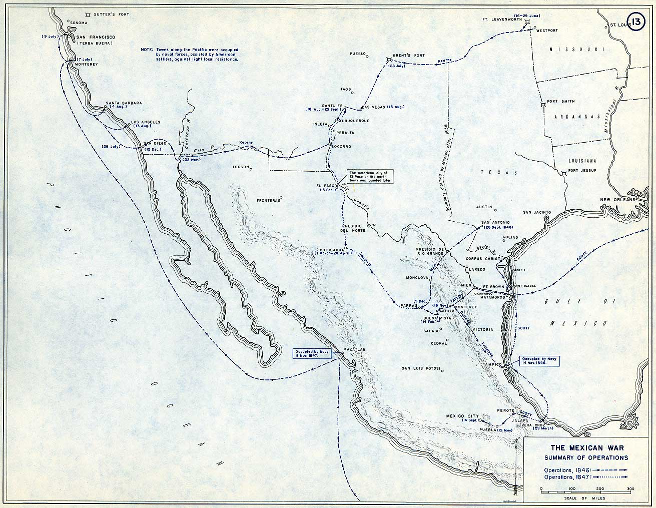
- US Military Academy: Summary of Operations, 1846-47 — US Military Academy Department of History; selected geographic facts reconstructed independently, original chart retained outside distributed files.. Geographic evidence only. Source atlas index requests reprint permission; original artwork not redistributed..
- US Military Academy: Principal Campaigns of the War — US Military Academy Department of History; selected geographic facts reconstructed independently, original chart retained outside distributed files.. Geographic evidence only. Source atlas index requests reprint permission; original artwork not redistributed..
- US Military Academy: Situation 18 and 24 July 1861 — US Military Academy Department of History; selected geographic facts reconstructed independently, original chart retained outside distributed files.. Geographic evidence only. Source atlas index requests reprint permission; original artwork not redistributed..
- US Military Academy: Situation Prior to the Opening, January 1862 — US Military Academy Department of History; selected geographic facts reconstructed independently, original chart retained outside distributed files.. Geographic evidence only. Source atlas index requests reprint permission; original artwork not redistributed..
- US Military Academy: Strategic Situation at the End of the Campaign, 27 February 1862 — US Military Academy Department of History; selected geographic facts reconstructed independently, original chart retained outside distributed files.. Geographic evidence only. Source atlas index requests reprint permission; original artwork not redistributed..
- US Military Academy: Situation, 7 September 1862 — US Military Academy Department of History; selected geographic facts reconstructed independently, original chart retained outside distributed files.. Geographic evidence only. Source atlas index requests reprint permission; original artwork not redistributed..
- US Military Academy: Southeastern United States, 1861 — US Military Academy Department of History; selected geographic facts reconstructed independently, original chart retained outside distributed files.. Geographic evidence only. Source atlas index requests reprint permission; original artwork not redistributed..
- US Military Academy: Northern Virginia, 19 November – 10 October — US Military Academy Department of History; selected geographic facts reconstructed independently, original chart retained outside distributed files.. Geographic evidence only. Source atlas index requests reprint permission; original artwork not redistributed..
- US Military Academy: Chattanooga and Vicinity, 1863 – Movements Since 24 June — US Military Academy Department of History; selected geographic facts reconstructed independently, original chart retained outside distributed files.. Geographic evidence only. Source atlas index requests reprint permission; original artwork not redistributed..
- US Military Academy: Chattanooga and Vicinity, 1863 – Opening the Gateway, 30 September -17 October — US Military Academy Department of History; selected geographic facts reconstructed independently, original chart retained outside distributed files.. Geographic evidence only. Source atlas index requests reprint permission; original artwork not redistributed..
- US Military Academy: Grant’s Plan for the 1864 Campaign — US Military Academy Department of History; selected geographic facts reconstructed independently, original chart retained outside distributed files.. Geographic evidence only. Source atlas index requests reprint permission; original artwork not redistributed..
- US Military Academy: Sherman’s Turning Movement, 26 August 1864 — US Military Academy Department of History; selected geographic facts reconstructed independently, original chart retained outside distributed files.. Geographic evidence only. Source atlas index requests reprint permission; original artwork not redistributed..
- US Military Academy: Principal Federal Movements, November 1864 – April 1865 — US Military Academy Department of History; selected geographic facts reconstructed independently, original chart retained outside distributed files.. Geographic evidence only. Source atlas index requests reprint permission; original artwork not redistributed..
- US Military Academy: Capture of Weldon Railroad, 18 August 1864 — US Military Academy Department of History; selected geographic facts reconstructed independently, original chart retained outside distributed files.. Geographic evidence only. Source atlas index requests reprint permission; original artwork not redistributed..
- US Military Academy: Battle of Five Forks, 29-31 March 1865 — US Military Academy Department of History; selected geographic facts reconstructed independently, original chart retained outside distributed files.. Geographic evidence only. Source atlas index requests reprint permission; original artwork not redistributed..
- US Military Academy: The Defeat of Lee, 3-9 April 1865 — US Military Academy Department of History; selected geographic facts reconstructed independently, original chart retained outside distributed files.. Geographic evidence only. Source atlas index requests reprint permission; original artwork not redistributed..
- US Military Academy: Richmond and Peninsula, 1862 – Stuart’s Raid, 12–15 June — US Military Academy Department of History; selected geographic facts reconstructed independently, original chart retained outside distributed files.. Geographic evidence only. Source atlas index requests reprint permission; original artwork not redistributed..


Remaking the State: Meiji Japan 1600–1912 and Post-Soviet Russia 1964–2000 · 21 sources
Browse the chapters and their source notes · Full layer records and reconstruction methods
- Natural Earth v5.1.2 complete geographic reference — Natural Earth contributors. Public domain.
- Natural Earth full administrative reference units — Natural Earth contributors. Public domain.
- Natural Earth v4.1.0 archived disputed territories (pre-2020 Karabakh) — Natural Earth contributors. Public domain.
- Natural Earth v5.1.2 disputed-area references — Natural Earth contributors. Public domain.
- Cliopatria v0.2.1 dated political boundaries — Cliopatria contributors / Seshat Global History Databank. CC BY 4.0.
- Edo Domains c.1862, v0.1 — iao (2025), using Rekihaku village-domain records and MAFF 2015 agricultural settlement geometry; upstream processing by yaoyue00085856. CC0 1.0.
- International Crisis Group: former Nagorno-Karabakh Autonomous Oblast geographic data — International Crisis Group. GPL-3.0.
- Atlas chapter bibliography and event-specific source record — Maps of History, citing the scholarly bibliography in SOURCES.md. Historical factual reference; no copyrighted prose reproduced.
- The World and Japan database: official historical treaties — GRIPS / University of Tokyo. Historical official treaty facts; no translated prose copied.
- Yamaguchi Prefecture: Hagi main domain and four branch domains — Yamaguchi Prefecture cultural heritage service. Historical factual evidence; no map or prose copied.
- Joint Japanese–Russian compendium of territorial treaties, 1855–1905 — Ministries of Foreign Affairs of Japan and the Russian Federation. Official historical treaty facts.
- UNESCO Memory of the World: the Baltic Way — UNESCO Memory of the World. Historical factual reference.
- Cliopatria v 0.2.1 — dated political boundaries — Cliopatria contributors / Seshat Global History Databank. CC BY4.0.
- Natural Earth v5.1.2 Amur / Heilong Jiang river centreline — Natural Earth contributors. Public domain.
- Natural Earth v5.1.2 country geography — Natural Earth contributors. Public domain.
- Cliopatria v0.2.1 historical polities — Cliopatria contributors / Seshat Global History Databank. CC BY 4.0.
- Natural Earth administrative references — Natural Earth contributors. Public domain.
- The rise and fall of the Berlin Wall — US government historical publication. Historical facts cited; no source artwork or prose reproduced.
- Decolonization of Asia and Africa, 1945–1960 — US Department of State, Office of the Historian. US government publication.
- The Berlin Airlift, 1948–1949 — US government historical publication. Historical facts cited; no source artwork or prose reproduced.
- Berlin’s four-power status and its termination — US government historical publication. Historical facts cited; no source artwork or prose reproduced.
The Russian Revolution, 1855–1924 · 23 sources
Browse the chapters and their source notes · Full layer records and reconstruction methods
- Cliopatria v0.2.1 — dated political boundaries — Cliopatria contributors / Seshat Global History Databank. CC BY4.0.
- US Military Academy — The War in Eastern Europe (1952), maps7 and15 — Department of Military Art and Engineering, United States Military Academy,1952. US federal government work; public domain maps.
- US War Department — Atlas of the World Battle Fronts (1945) — United States War Department, General Staff,1945. US Army official work; public domain.
- US Army Center of Military History — American Military History, The War Against Japan — Office of the Chief of Military History,1969, chapter23. Official US Army text and maps; public domain.
- United States Holocaust Memorial Museum — German territorial expansion — United States Holocaust Memorial Museum. Historical dates consulted; no prose or image copied.
- French Ministry of the Armed Forces — La ligne de démarcation — Ministère des Armées. Historical facts consulted; actual polygon imported from Cliopatria.
- Allied governments — zones of occupation and administration of Greater Berlin, 26 July 1945 — Allied governments, 1945 protocol. Historical administrative facts consulted.
- Natural Earth — physical reference geography — Natural Earth. Public domain.
- Library of Congress — Russian Civil War campaign map 03 (1920s original) — A. N. de-Lazari, N. N. Lesevitskii and collaborators; Gosizdat, RSFSR. Historical geographic facts independently reconstructed; original artwork not republished.
- Library of Congress — Russian Civil War campaign map 05 (1920s original) — A. N. de-Lazari, N. N. Lesevitskii and collaborators; Gosizdat, RSFSR. Historical geographic facts independently reconstructed; original artwork not republished.
- Library of Congress — Russian Civil War campaign map 08 (1920s original) — A. N. de-Lazari, N. N. Lesevitskii and collaborators; Gosizdat, RSFSR. Historical geographic facts independently reconstructed; original artwork not republished.
- Library of Congress — Russian Civil War campaign map 02 (1920s original) — A. N. de-Lazari, N. N. Lesevitskii and collaborators; Gosizdat, RSFSR. Historical geographic facts independently reconstructed; original artwork not republished.
- Library of Congress — Russian Civil War campaign map 04 (1920s original) — A. N. de-Lazari, N. N. Lesevitskii and collaborators; Gosizdat, RSFSR. Historical geographic facts independently reconstructed; original artwork not republished.
- Library of Congress — Russian Civil War campaign map 06 (1920s original) — A. N. de-Lazari, N. N. Lesevitskii and collaborators; Gosizdat, RSFSR. Historical geographic facts independently reconstructed; original artwork not republished.
- Library of Congress — Russian Civil War campaign map 07 (1920s original) — A. N. de-Lazari, N. N. Lesevitskii and collaborators; Gosizdat, RSFSR. Historical geographic facts independently reconstructed; original artwork not republished.
- Library of Congress — Russian Civil War campaign map 09 (1920s original) — A. N. de-Lazari, N. N. Lesevitskii and collaborators; Gosizdat, RSFSR. Historical geographic facts independently reconstructed; original artwork not republished.
- Library of Congress — Russian Civil War campaign map 10 (1920s original) — A. N. de-Lazari, N. N. Lesevitskii and collaborators; Gosizdat, RSFSR. Historical geographic facts independently reconstructed; original artwork not republished.
- C. Perron / Élisée Reclus — Russian Encroachments in Turkestan (1884) — C. Perron / Élisée Reclus — Russian Encroachments in Turkestan (1884). Historical map published before 1931; independently digitized factual geography. Original scan not republished..
- Cambridge Modern History Atlas, map 108 — Russia in Europe (1912) — Cambridge Modern History Atlas, map 108 — Russia in Europe (1912). Historical map published before 1931; independently digitized factual geography. Original scan not republished..
- The Jewish Encyclopedia (1901), volume 10 — Pale of Settlement map — The Jewish Encyclopedia (1901), volume 10 — Pale of Settlement map. Historical map published before 1931; independently digitized factual geography. Original scan not republished..
- Pamir Boundary Commission — signed delimitation map, 1895/1896 — Pamir Boundary Commission — signed delimitation map, 1895/1896. Public domain.
- US Department of State — Kwantung leased territory chronology — US Department of State — Kwantung leased territory chronology. US government historical document; factual chronology consulted.
- USMA — World War I atlas, chart 41 — USMA — World War I atlas, chart 41. Factual geographic reconstruction; original chart artwork not republished.

Indian Independence & Partition, 1857–1964 · 15 sources
Browse the chapters and their source notes · Full layer records and reconstruction methods
- Natural Earth v5.1.2: complete country reference geometry — Natural Earth. Public domain.
- Natural Earth: administrative reference units — Natural Earth. Public domain.
- Cliopatria v0.2.1: dated historical polity records — Cliopatria contributors / Seshat Global History Databank. CC BY 4.0.
- Imperial Gazetteer of India (1908): Indian Empire political plate — J. G. Bartholomew / Imperial Gazetteer of India, 1908; scan Fowler & Fowler. Public domain.
- Imperial Gazetteer Atlas (1907): India in 1837 and 1857 — Imperial Gazetteer Atlas of India / Edinburgh Geographical Institute. Public domain.
- geoBoundaries India ADM2 (2021): named district reference geometry — geoBoundaries / Pathways Data Pvt Ltd / lgdirectory.gov.in. ODbL 1.0.
- Census of India 1931: provincial and state administrative reference — Office of the Registrar General & Census Commissioner, India; administrative grouping reference. Historical factual reference; no source prose reproduced.
- States Reorganisation Act, 1956 — Government of India; historical state-grouping reference. Historical factual reference; no source prose reproduced.
- UK National Archives: the Partition of British India — UK National Archives; award and independence context, not modern boundary geometry. Historical factual reference; no source prose reproduced.
- UNMOGIP: background to the Kashmir ceasefire line — United Nations Military Observer Group in India and Pakistan. Historical factual reference; no source prose reproduced.
- Cambridge Modern History Atlas (1912): principal centres of the 1857–1859 rebellion — Cambridge University Press / Stanford’s Geographical Establishment; 1912. Public domain.
- National Archives of India: Abhilekh Patal historical records portal — National Archives of India; contextual historical records, not a boundary survey. Historical factual reference; no source prose reproduced.
- Punjab Reorganisation Act, 1966 — Government of India; transfer to Himachal takes effect 1 November 1966. Historical factual reference; no source prose reproduced.
- Odisha Legislative Assembly: formation of the separate province, 1936 — Odisha Legislative Assembly. Historical factual reference; no source prose reproduced.
- Government of Maharashtra: Vidarbha in Central Provinces and Berar — Government of Maharashtra, Kelkar committee report, chapter 1. Historical factual reference; no source prose reproduced.


The Great War, 1871–1923 · 44 sources
Browse the chapters and their source notes · Full layer records and reconstruction methods
- Cliopatria v 0.2.1 — Cliopatria contributors / Seshat Global History Databank. Source polygons retained with original identities; geographic selections and corrections by Maps of History.. CC BY 4.0.
- Natural Earth physical geography — Made with Natural Earth; geographic reference and physical land only. No modern political boundary is used as a historical boundary.. Public domain.
- Anglo-Russian Convention, 31 August 1907, articles I–II — US Department of State, Foreign Relations of the United States; convention’s named places define the two concession spheres.. Historical treaty facts, independently reconstructed.
- German barred-zone declaration, February 1917 — US Naval Institute Proceedings, March 1917, German declaration transcribed; February 3 Dutch safety-strip correction described separately.. Published 1917 historical document; factual boundary coordinates transcribed.
- February 1917 shipping-zone amendments — Commercial and Financial Chronicle,10 February 1917, preserved by Federal Reserve Bank of St Louis.. Historical factual coordinate transcription; no scan redistributed.
- Treaty of Peace with Turkey, Sèvres, 10 August 1920 — UK Treaty Series 11/1920. The signed treaty never entered into force; proposal outlines remain distinct from actual occupation.. Historical treaty facts; no artwork redistributed.
- British Library Sèvres treaty maps and rights record — British Library India Office Records IOR/W/L/PS/18/B 356. The IIIF manifest download returned 403; no unavailable map is described as acquired.. The three government map sheets are listed as Open Government Licence; the volume text has a separate unknown-copyright notice.
- National Army Museum: Mesopotamia campaign — National Army Museum; Basra, Kut, Baghdad and late 1917 campaign positions.. Historical evidence citation, no artwork copied.
- National Army Museum: Ramadi, September 1917 — National Army Museum, accession 1965-10-209-49; Ramadi captured 28–29 September 1917.. Historical evidence citation.
- Polish educational platform: Battle of Warsaw, 1920 — Polish Ministry educational platform: Wkra, Radzymin, Wieprz and the Warsaw campaign.. Historical geographic facts, independently reconstructed; artwork not copied.
- Treaty of Versailles: Rhineland occupation — Versailles articles 428–432; Rhineland occupation and bridgeheads.. Historical treaty facts; original geographic reconstruction.
- German Federal Archives: occupation of the Ruhr, 1923 — Bundesarchiv,11 January 1923; geographic industrial district occupation.. Historical evidence citation; no artwork copied.
- National Army Museum: Gallipoli campaign — National Army Museum: Helles, Anzac and the August Suvla landing remained three beachhead sectors.. Historical evidence citation; no artwork copied.
- National Army Museum: Salonika campaign — National Army Museum: late 1916 Albanian coast–Monastir–Doiran–Struma line and 1918 liberation campaign.. Historical evidence citation; no artwork copied.
- Caucasus Front, 1914–1918 Online — Tigran Martirosyan, University of Amsterdam; Russian 1916 advance, Erzincan and Bitlis geographic extent.. Historical geographic facts cited; no map copied.
- Treaty of Berlin, 1878, articles XXVIII–XXIX — US Department of State, Foreign Relations 1878; Montenegro frontier and coastal transfers.. Historical treaty geographic facts.
- Balkan Wars 1912–1913, International Encyclopedia of the First World War — Richard C. Hall; November 1912 Chataldzha defensive line and December armistice.. Historical geographic evidence, independent reconstruction.
- UK Parliament: Asia Minor, 10 July 1919 — Hansard; Italian Adalia garrison and southwestern coastal detachments.. Historical geographic evidence citation.
- British Library: Curzon papers, Italian forces in Asia Minor, 1919 — British Library via Qatar Digital Library; Adalia, Budjak, Buldur, Makri, Marmarice, Budrum, Sokia and Scalanova detachments.. Historical factual location citation; no scan redistributed.
- US Army: American Forces in Germany — US Army Medical Department history; Moselle Valley from Luxembourg to Rhine, Trier and Koblenz. Boundary derived from treaty river and bridgehead provisions rather than an absent annual control polygon.. US government historical geographic evidence.
- Maps of History: Great War geographic decisions — Maps of History. Campaign-sector connectors and contextual regions are identified separately from imported vector outlines.. Original geographic reconstruction using attributed historical evidence.
- US Military Academy World War I atlas, chart 1 — US Military Academy, Department of History & War Studies, World War I chart 1. Selected geographic front facts reconstructed independently; no claim of blanket public-domain artwork rights.. Geographic evidence citation; source index requests permission for map reprints. Original artwork is not redistributed..
- US Military Academy World War I atlas, chart 2 — US Military Academy, Department of History & War Studies, World War I chart 2. Selected geographic front facts reconstructed independently; no claim of blanket public-domain artwork rights.. Geographic evidence citation; source index requests permission for map reprints. Original artwork is not redistributed..
- US Military Academy World War I atlas, chart 10 — US Military Academy, Department of History & War Studies, World War I chart 10. Selected geographic front facts reconstructed independently; no claim of blanket public-domain artwork rights.. Geographic evidence citation; source index requests permission for map reprints. Original artwork is not redistributed..
- US Military Academy World War I atlas, chart 11 — US Military Academy, Department of History & War Studies, World War I chart 11. Selected geographic front facts reconstructed independently; no claim of blanket public-domain artwork rights.. Geographic evidence citation; source index requests permission for map reprints. Original artwork is not redistributed..
- US Military Academy World War I atlas, chart 14 — US Military Academy, Department of History & War Studies, World War I chart 14. Selected geographic front facts reconstructed independently; no claim of blanket public-domain artwork rights.. Geographic evidence citation; source index requests permission for map reprints. Original artwork is not redistributed..
- US Military Academy World War I atlas, chart 15 — US Military Academy, Department of History & War Studies, World War I chart 15. Selected geographic front facts reconstructed independently; no claim of blanket public-domain artwork rights.. Geographic evidence citation; source index requests permission for map reprints. Original artwork is not redistributed..
- US Military Academy World War I atlas, chart 16 — US Military Academy, Department of History & War Studies, World War I chart 16. Selected geographic front facts reconstructed independently; no claim of blanket public-domain artwork rights.. Geographic evidence citation; source index requests permission for map reprints. Original artwork is not redistributed..
- US Military Academy World War I atlas, chart 18 — US Military Academy, Department of History & War Studies, World War I chart 18. Selected geographic front facts reconstructed independently; no claim of blanket public-domain artwork rights.. Geographic evidence citation; source index requests permission for map reprints. Original artwork is not redistributed..
- US Military Academy World War I atlas, chart 20 — US Military Academy, Department of History & War Studies, World War I chart 20. Selected geographic front facts reconstructed independently; no claim of blanket public-domain artwork rights.. Geographic evidence citation; source index requests permission for map reprints. Original artwork is not redistributed..
- US Military Academy World War I atlas, chart 23 — US Military Academy, Department of History & War Studies, World War I chart 23. Selected geographic front facts reconstructed independently; no claim of blanket public-domain artwork rights.. Geographic evidence citation; source index requests permission for map reprints. Original artwork is not redistributed..
- US Military Academy World War I atlas, chart 28 — US Military Academy, Department of History & War Studies, World War I chart 28. Selected geographic front facts reconstructed independently; no claim of blanket public-domain artwork rights.. Geographic evidence citation; source index requests permission for map reprints. Original artwork is not redistributed..
- US Military Academy World War I atlas, chart 29 — US Military Academy, Department of History & War Studies, World War I chart 29. Selected geographic front facts reconstructed independently; no claim of blanket public-domain artwork rights.. Geographic evidence citation; source index requests permission for map reprints. Original artwork is not redistributed..
- US Military Academy World War I atlas, chart 31 — US Military Academy, Department of History & War Studies, World War I chart 31. Selected geographic front facts reconstructed independently; no claim of blanket public-domain artwork rights.. Geographic evidence citation; source index requests permission for map reprints. Original artwork is not redistributed..
- US Military Academy World War I atlas, chart 34 — US Military Academy, Department of History & War Studies, World War I chart 34. Selected geographic front facts reconstructed independently; no claim of blanket public-domain artwork rights.. Geographic evidence citation; source index requests permission for map reprints. Original artwork is not redistributed..
- US Military Academy World War I atlas, chart 35 — US Military Academy, Department of History & War Studies, World War I chart 35. Selected geographic front facts reconstructed independently; no claim of blanket public-domain artwork rights.. Geographic evidence citation; source index requests permission for map reprints. Original artwork is not redistributed..
- US Military Academy World War I atlas, chart 38 — US Military Academy, Department of History & War Studies, World War I chart 38. Selected geographic front facts reconstructed independently; no claim of blanket public-domain artwork rights.. Geographic evidence citation; source index requests permission for map reprints. Original artwork is not redistributed..
- US Military Academy World War I atlas, chart 39 — US Military Academy, Department of History & War Studies, World War I chart 39. Selected geographic front facts reconstructed independently; no claim of blanket public-domain artwork rights.. Geographic evidence citation; source index requests permission for map reprints. Original artwork is not redistributed..
- US Military Academy World War I atlas, chart 41 — US Military Academy, Department of History & War Studies, World War I chart 41. Selected geographic front facts reconstructed independently; no claim of blanket public-domain artwork rights.. Geographic evidence citation; source index requests permission for map reprints. Original artwork is not redistributed..
- US Military Academy World War I atlas, chart 44 — US Military Academy, Department of History & War Studies, World War I chart 44. Selected geographic front facts reconstructed independently; no claim of blanket public-domain artwork rights.. Geographic evidence citation; source index requests permission for map reprints. Original artwork is not redistributed..
- US Military Academy World War I atlas, chart 47 — US Military Academy, Department of History & War Studies, World War I chart 47. Selected geographic front facts reconstructed independently; no claim of blanket public-domain artwork rights.. Geographic evidence citation; source index requests permission for map reprints. Original artwork is not redistributed..
- US Military Academy World War I atlas, chart 49 — US Military Academy, Department of History & War Studies, World War I chart 49. Selected geographic front facts reconstructed independently; no claim of blanket public-domain artwork rights.. Geographic evidence citation; source index requests permission for map reprints. Original artwork is not redistributed..
- US Military Academy World War I atlas, chart 51 — US Military Academy, Department of History & War Studies, World War I chart 51. Selected geographic front facts reconstructed independently; no claim of blanket public-domain artwork rights.. Geographic evidence citation; source index requests permission for map reprints. Original artwork is not redistributed..
- US Military Academy World War I atlas, chart 52 — US Military Academy, Department of History & War Studies, World War I chart 52. Selected geographic front facts reconstructed independently; no claim of blanket public-domain artwork rights.. Geographic evidence citation; source index requests permission for map reprints. Original artwork is not redistributed..


China in Revolution, 1911–1949 · 32 sources
Browse the chapters and their source notes · Full layer records and reconstruction methods
- Cliopatria v 0.2.1 — dated political boundaries — Cliopatria contributors / Seshat Global History Databank. CC BY4.0.
- US Military Academy — The War in Eastern Europe (1952), maps 7 and 15 — Department of Military Art and Engineering, United States Military Academy,1952. US federal government work; public domain maps.
- US War Department — Atlas of the World Battle Fronts (1945) — United States War Department, General Staff,1945. US Army official work; public domain.
- US Army Center of Military History — American Military History, The War Against Japan — Office of the Chief of Military History,1969, chapter 23. Official US Army text and maps; public domain.
- United States Holocaust Memorial Museum — German territorial expansion — United States Holocaust Memorial Museum. Historical dates consulted; no prose or image copied.
- French Ministry of the Armed Forces — La ligne de démarcation — Ministère des Armées. Historical facts consulted; actual polygon imported from Cliopatria.
- Allied governments — zones of occupation and administration of Greater Berlin, 26 July 1945 — Allied governments, 1945 protocol. Historical administrative facts consulted.
- Natural Earth — physical reference geography — Natural Earth. Public domain.
- USMA: Warlords, 1925 — United States Military Academy, Department of History, Digital History Center. Source-map facts used for independent geographic reconstruction; original chart artwork is not republished.
- USMA: Nationalist China, 1929-37 — United States Military Academy, Department of History, Digital History Center. Source-map facts used for independent geographic reconstruction; original chart artwork is not republished.
- USMA: Long March, 1934-35 — United States Military Academy, Department of History, Digital History Center. Source-map facts used for independent geographic reconstruction; original chart artwork is not republished.
- USMA: Japanese Occupation, 1940 — United States Military Academy, Department of History, Digital History Center. Source-map facts used for independent geographic reconstruction; original chart artwork is not republished.
- USMA: Situation at the End of World War II — United States Military Academy, Department of History, Digital History Center. Source-map facts used for independent geographic reconstruction; original chart artwork is not republished.
- USMA: Chiang Kai-shek’s Strategy, 1947 — United States Military Academy, Department of History, Digital History Center. Source-map facts used for independent geographic reconstruction; original chart artwork is not republished.
- USMA: Communist Offensives, September-November 1948 — United States Military Academy, Department of History, Digital History Center. Source-map facts used for independent geographic reconstruction; original chart artwork is not republished.
- USMA: Communist Offensives, November 1948 – January 1949 — United States Military Academy, Department of History, Digital History Center. Source-map facts used for independent geographic reconstruction; original chart artwork is not republished.
- USMA: Communist Offensives, April-October 1949 — United States Military Academy, Department of History, Digital History Center. Source-map facts used for independent geographic reconstruction; original chart artwork is not republished.
- US Consul at Mukden — report of 26 September 1931 — US Consul at Mukden — report of 26 September 1931. Historical facts consulted; no source artwork or prose republished.
- US diplomatic records — Jehol occupation,March 1933 — US diplomatic records — Jehol occupation,March 1933. Historical facts consulted; no source artwork or prose republished.
- National Diet Library — Marco Polo Bridge and Beijing/Tianjin chronology — National Diet Library — Marco Polo Bridge and Beijing/Tianjin chronology. Historical facts consulted; no source artwork or prose republished.
- US Consul at Hanoi — Japanese bases agreement,22 September 1940 — US Consul at Hanoi — Japanese bases agreement,22 September 1940. Historical facts consulted; no source artwork or prose republished.
- US Chargé — fall of Langson and Haiphong landings,26 September 1940 — US Chargé — fall of Langson and Haiphong landings,26 September 1940. Historical facts consulted; no source artwork or prose republished.
- United Press dispatch,21 July 1936 — Seville rebel stronghold — United Press dispatch,21 July 1936 — Seville rebel stronghold. Historical facts consulted; no source artwork or prose republished.
- Australian War Memorial — fall of Gondar and end of Italian control,November 1941 — Australian War Memorial — fall of Gondar and end of Italian control,November 1941. Historical facts consulted; no source artwork or prose republished.
- Tangku Truce Agreement,31May1933 — published primary text — Tangku Truce Agreement,31May1933 — published primary text. Historical facts consulted; original prose/artwork not republished.
- USArmy Center ofMilitaryHistory — China Defensive campaign — USArmy Center ofMilitaryHistory — China Defensive campaign. Historical facts consulted; original prose/artwork not republished.
- US AmbassadorStuart — evacuation andcapture ofYenan,1947 — US AmbassadorStuart — evacuation andcapture ofYenan,1947. Historical facts consulted; original prose/artwork not republished.
- USdiplomatic records — fallofCanton,Chungking andKunming,October–December1949 — USdiplomatic records — fallofCanton,Chungking andKunming,October–December1949. Historical facts consulted; original prose/artwork not republished.
- ChineseMilitaryHistory — Taiyuan captured24April1949 — ChineseMilitaryHistory — Taiyuan captured24April1949. Historical facts consulted; original prose/artwork not republished.
- USOfficeoftheHistorian — ChineseRevolutionof1949 — USOfficeoftheHistorian — ChineseRevolutionof1949. Historical facts consulted; original prose/artwork not republished.
- Natural Earth10m — province reference geometry — Natural Earth10m — province reference geometry. Public domain.
- Natural Earth10m — rivers/lake centerlines,ChangJiang — Natural Earth10m — rivers/lake centerlines,ChangJiang. Public domain.


The Soviet Union under Stalin, 1924–1953 · 23 sources
Browse the chapters and their source notes · Full layer records and reconstruction methods
- Cliopatria v0.2.1 historical political boundaries — Cliopatria contributors / Seshat Global History Databank. CC BY 4.0.
- Natural Earth v5.1.2 country geography — Natural Earth contributors. Public domain.
- Natural Earth full administrative reference geometry — Natural Earth contributors. Public domain.
- Bukharan PSR in the Soviet Union (1922), published vector locator — TRAJAN 117, TarzanASG, Anonimu and Milenioscuro; underlying location-map geography by Hellerick/Natural Earth. CC BY-SA 3.0.
- Published projection for the Soviet Union location-map family — Hellerick. Mathematical projection parameters; source artwork CC BY-SA 3.0.
- Revelations from the Russian Archives: internal workings, collectivisation, famine and deportations — Library of Congress / Russian archival exhibition. Historical facts consulted; no copyrighted artwork or prose reproduced.
- Volga German ASSR, 20 July 1930: published locator map — Fotisgrek. CC BY-SA 4.0.
- Cliopatria v 0.2.1 — dated political boundaries — Cliopatria contributors / Seshat Global History Databank. CC BY4.0.
- US Military Academy — The War in Eastern Europe (1952), maps 7 and 15 — Department of Military Art and Engineering, United States Military Academy,1952. US federal government work; public domain maps.
- US War Department — Atlas of the World Battle Fronts (1945) — United States War Department, General Staff,1945. US Army official work; public domain.
- Cliopatria v 0.2.1 — dated political boundaries — Cliopatria contributors / Seshat Global History Databank. CC BY4.0.
- Natural Earth v5.1.2 country geography — Natural Earth contributors. Public domain.
- Decolonization of Asia and Africa, 1945–1960 — US Department of State, Office of the Historian. US government publication.
- Cliopatria v0.2.1 historical polities — Cliopatria contributors / Seshat Global History Databank. CC BY 4.0.
- Natural Earth administrative references — Natural Earth contributors. Public domain.
- The rise and fall of the Berlin Wall — US government historical publication. Historical facts cited; no source artwork or prose reproduced.
- The Berlin Airlift, 1948–1949 — US government historical publication. Historical facts cited; no source artwork or prose reproduced.
- Berlin’s four-power status and its termination — US government historical publication. Historical facts cited; no source artwork or prose reproduced.
- Cliopatria v0.2.1 — dated political boundaries — Cliopatria contributors / Seshat Global History Databank. CC BY4.0.
- USdiplomatic records — fallof Canton,Chungking and Kunming,October–December 1949 — USdiplomatic records — fallof Canton,Chungking and Kunming,October–December 1949. Historical facts consulted; original prose/artwork not republished.
- Natural Earth 10m — provincial study-region reference — Natural Earth 10m — provincial study-region reference. Public domain.
- Natural Earth 10m island components; FRUS 1955 evacuation chronology — Natural Earth 10m island components; FRUS 1955 evacuation chronology. Natural Earth public domain; historical facts consulted.
- Natural Earth — physical reference geography — Natural Earth. Public domain.


The Road to War, 1931–1941 · 30 sources
Browse the chapters and their source notes · Full layer records and reconstruction methods
- Cliopatria v0.2.1 — dated political boundaries — Cliopatria contributors / Seshat Global History Databank. CC BY4.0.
- US Military Academy — The War in Eastern Europe (1952), maps7 and15 — Department of Military Art and Engineering, United States Military Academy,1952. US federal government work; public domain maps.
- US War Department — Atlas of the World Battle Fronts (1945) — United States War Department, General Staff,1945. US Army official work; public domain.
- US Army Center of Military History — American Military History, The War Against Japan — Office of the Chief of Military History,1969, chapter23. Official US Army text and maps; public domain.
- United States Holocaust Memorial Museum — German territorial expansion — United States Holocaust Memorial Museum. Historical dates consulted; no prose or image copied.
- French Ministry of the Armed Forces — La ligne de démarcation — Ministère des Armées. Historical facts consulted; actual polygon imported from Cliopatria.
- Allied governments — zones of occupation and administration of Greater Berlin, 26 July 1945 — Allied governments, 1945 protocol. Historical administrative facts consulted.
- Natural Earth — physical reference geography — Natural Earth. Public domain.
- USMA: Japanese Occupation, 1940 — United States Military Academy, Department of History, Digital History Center. Source-map facts used for independent geographic reconstruction; original chart artwork is not republished.
- US Consul at Mukden — report of26September1931 — US Consul at Mukden — report of26September1931. Historical facts consulted; no source artwork or prose republished.
- US diplomatic records — Jehol occupation,March1933 — US diplomatic records — Jehol occupation,March1933. Historical facts consulted; no source artwork or prose republished.
- National Diet Library — MarcoPoloBridge and Beijing/Tianjin chronology — National Diet Library — MarcoPoloBridge and Beijing/Tianjin chronology. Historical facts consulted; no source artwork or prose republished.
- US Consul at Hanoi — Japanese bases agreement,22September1940 — US Consul at Hanoi — Japanese bases agreement,22September1940. Historical facts consulted; no source artwork or prose republished.
- US Chargé — fall ofLangson andHaiphong landings,26September1940 — US Chargé — fall ofLangson andHaiphong landings,26September1940. Historical facts consulted; no source artwork or prose republished.
- UnitedPress dispatch,21July1936 — Seville rebel stronghold — UnitedPress dispatch,21July1936 — Seville rebel stronghold. Historical facts consulted; no source artwork or prose republished.
- Australian War Memorial — fall ofGondar and end ofItalian control,November1941 — Australian War Memorial — fall ofGondar and end ofItalian control,November1941. Historical facts consulted; no source artwork or prose republished.
- Murli / rowanwindwhistler — Slovakia border changes, 1938–1945 — Murli; SVG adaptation by rowanwindwhistler (2021). CC BY-SA 2.5; derived geographic paths under the same license.
- United States Holocaust Memorial Museum — The Holocaust in Slovakia — United States Holocaust Memorial Museum — The Holocaust in Slovakia. Historical chronology consulted; no source prose or artwork republished.
- Slovak Nation’s Memory Institute — The First Vienna Award — Slovak Nation’s Memory Institute — The First Vienna Award. Historical territorial chronology consulted; no source artwork or prose republished.
- United States Holocaust Memorial Museum — Hitler appointed chancellor, 30 January 1933 — United States Holocaust Memorial Museum — Hitler appointed chancellor, 30 January 1933. Historical chronology consulted; no source prose or artwork republished.
- Yugoslavia (1929–1939) location map — international frontier and Adriatic coast — NordNordWest/Wikipedia. Converted from the published SVG to WGS84; eastern Italian regional territory extracted. Source cites Velhagen & Klasings Großer Volksatlas (1938).. CC BY-SA 3.0 Germany.
- IGM Fiume, 1:25,000, sheet53B II SE — boundary established in1924 — Istituto Geografico Militare, Fiume (printed1946; 1927 survey with1931–1940 updates), reproduced by Istituto regionale per la storia della Resistenza e dell’Età contemporanea nel Friuli Venezia Giulia. Independent reconstruction from graticule coordinates and boundary observations; archive page reserves artwork rights.. Geographical-fact reconstruction; original archive artwork not distributed.
- Treaty of Rome (1924), division of Fiume and west-bank boundary — 1924 agreement interpreted alongside the regional history institute and City of Rijeka’s explanation of the Donja/Gornja Drenova division.. Historical geographic facts; citation only.
- Regional history institute — Adriatic occupation chronology,1943–1945 — Regional history institute — Adriatic occupation chronology,1943–1945. Historical geographic facts consulted; source prose and artwork not republished.
- Regional history institute — Italian annexations of1941, Fiume province and Krk — Regional history institute — Italian annexations of1941, Fiume province and Krk. Historical geographic facts consulted; source prose and artwork not republished.
- Regional history institute — Zara evacuation and Yugoslav entry,October1944 — Regional history institute — Zara evacuation and Yugoslav entry,October1944. Historical geographic facts consulted; source prose and artwork not republished.
- Miroslav Krleža Lexicographic Institute — Lastovo wartime chronology — Miroslav Krleža Lexicographic Institute — Lastovo wartime chronology. Historical geographic facts consulted; source prose and artwork not republished.
- National Museum of Contemporary History of Slovenia — Allied/Yugoslav presence and Morgan demarcation — National Museum of Contemporary History of Slovenia — Allied/Yugoslav presence and Morgan demarcation. Historical geographic facts consulted; source prose and artwork not republished.
- Regional history institute — Morgan Line and Pola enclave,1945–1947 — Istituto regionale per la storia della Resistenza e dell’Età contemporanea nel Friuli Venezia Giulia. Independent geographic-fact reconstruction; original artwork not distributed.
- United States Holocaust Memorial Museum — Danzig and German annexation in September 1939 — United States Holocaust Memorial Museum — Danzig and German annexation in September 1939. Historical chronology consulted; no source prose or artwork republished.


The War Room — WW2, 1936–1945 · 22 sources
Browse the chapters and their source notes · Full layer records and reconstruction methods
- Cliopatria v0.2.1 — dated political boundaries — Cliopatria contributors / Seshat Global History Databank. CC BY4.0.
- US Military Academy — The War in Eastern Europe (1952), maps7 and15 — Department of Military Art and Engineering, United States Military Academy,1952. US federal government work; public domain maps.
- US War Department — Atlas of the World Battle Fronts (1945) — United States War Department, General Staff,1945. US Army official work; public domain.
- US Army Center of Military History — American Military History, The War Against Japan — Office of the Chief of Military History,1969, chapter23. Official US Army text and maps; public domain.
- United States Holocaust Memorial Museum — German territorial expansion — United States Holocaust Memorial Museum. Historical dates consulted; no prose or image copied.
- French Ministry of the Armed Forces — La ligne de démarcation — Ministère des Armées. Historical facts consulted; actual polygon imported from Cliopatria.
- Allied governments — zones of occupation and administration of Greater Berlin, 26 July 1945 — Allied governments, 1945 protocol. Historical administrative facts consulted.
- Natural Earth — physical reference geography — Natural Earth. Public domain.
- Yugoslavia (1929–1939) location map — international frontier and Adriatic coast — NordNordWest/Wikipedia. Converted from the published SVG to WGS84; eastern Italian regional territory extracted. Source cites Velhagen & Klasings Großer Volksatlas (1938).. CC BY-SA 3.0 Germany.
- IGM Fiume, 1:25,000, sheet53B II SE — boundary established in1924 — Istituto Geografico Militare, Fiume (printed1946; 1927 survey with1931–1940 updates), reproduced by Istituto regionale per la storia della Resistenza e dell’Età contemporanea nel Friuli Venezia Giulia. Independent reconstruction from graticule coordinates and boundary observations; archive page reserves artwork rights.. Geographical-fact reconstruction; original archive artwork not distributed.
- Treaty of Rome (1924), division of Fiume and west-bank boundary — 1924 agreement interpreted alongside the regional history institute and City of Rijeka’s explanation of the Donja/Gornja Drenova division.. Historical geographic facts; citation only.
- Regional history institute — Adriatic occupation chronology,1943–1945 — Regional history institute — Adriatic occupation chronology,1943–1945. Historical geographic facts consulted; source prose and artwork not republished.
- Regional history institute — Italian annexations of1941, Fiume province and Krk — Regional history institute — Italian annexations of1941, Fiume province and Krk. Historical geographic facts consulted; source prose and artwork not republished.
- Regional history institute — Zara evacuation and Yugoslav entry,October1944 — Regional history institute — Zara evacuation and Yugoslav entry,October1944. Historical geographic facts consulted; source prose and artwork not republished.
- Miroslav Krleža Lexicographic Institute — Lastovo wartime chronology — Miroslav Krleža Lexicographic Institute — Lastovo wartime chronology. Historical geographic facts consulted; source prose and artwork not republished.
- National Museum of Contemporary History of Slovenia — Allied/Yugoslav presence and Morgan demarcation — National Museum of Contemporary History of Slovenia — Allied/Yugoslav presence and Morgan demarcation. Historical geographic facts consulted; source prose and artwork not republished.
- Regional history institute — Morgan Line and Pola enclave,1945–1947 — Istituto regionale per la storia della Resistenza e dell’Età contemporanea nel Friuli Venezia Giulia. Independent geographic-fact reconstruction; original artwork not distributed.
- Murli / rowanwindwhistler — Slovakia border changes, 1938–1945 — Murli; SVG adaptation by rowanwindwhistler (2021). CC BY-SA 2.5; derived geographic paths under the same license.
- United States Holocaust Memorial Museum — The Holocaust in Slovakia — United States Holocaust Memorial Museum — The Holocaust in Slovakia. Historical chronology consulted; no source prose or artwork republished.
- Slovak Nation’s Memory Institute — The First Vienna Award — Slovak Nation’s Memory Institute — The First Vienna Award. Historical territorial chronology consulted; no source artwork or prose republished.
- United States Holocaust Memorial Museum — Danzig and German annexation in September 1939 — United States Holocaust Memorial Museum — Danzig and German annexation in September 1939. Historical chronology consulted; no source prose or artwork republished.
- Albanian Armed Forces Museum — German takeover after the Italian capitulation — Albanian Armed Forces Museum. Historical control chronology consulted; no source prose or artwork republished.
The Cold War, 1945–1991 · 23 sources
Browse the chapters and their source notes · Full layer records and reconstruction methods
- Natural Earth v5.1.2 country geography — Natural Earth contributors. Public domain.
- Natural Earth administrative references — Natural Earth contributors. Public domain.
- Natural Earth river centerlines — Natural Earth contributors. Public domain.
- Cliopatria v0.2.1 historical polities — Cliopatria contributors / Seshat Global History Databank. CC BY 4.0.
- 1945 agreement on occupation zones in Austria — US Department of State, Foreign Relations of the United States. US government public-domain document.
- City of Vienna: July 1945 occupation agreement — City of Vienna historical record. Historical facts cited; no source artwork or prose reproduced.
- 1954 Geneva agreement, Annex I: demarcation line — US Department of State, FRUS 1952–1954, Volume XVI, document 1035. US government publication of diplomatic documents.
- United Nations Command: the 1953 armistice — United Nations Command. Historical facts cited; no source artwork or prose reproduced.
- Occupation and reconstruction of Germany, 1945–1948 — National Army Museum. Historical facts cited; no source artwork or prose reproduced.
- Decolonization of Asia and Africa, 1945–1960 — US Department of State, Office of the Historian. US government publication.
- The collapse of the Soviet Union — US Department of State, Office of the Historian. US government publication.
- The Chinese Revolution of 1949 — US Department of State, Office of the Historian. US government publication.
- NATO membership chronology — NATO. Historical facts cited; no artwork or prose reproduced.
- North Atlantic Treaty: Algerian departments cease to apply from 3 July 1962 — NATO, treaty footnote 2. Historical treaty facts cited; no artwork or prose reproduced.
- South Yemen: independence and alignment chronology — US Department of State. US government historical publication.
- South Yemen: Soviet relationship, 1971 intelligence estimate — US Department of State, FRUS 1969–1976, volume XXIV, document 182. US government historical publication.
- The Berlin Airlift, 1948–1949 — US government historical publication. Historical facts cited; no source artwork or prose reproduced.
- US Army Korean War campaigns — US government historical publication. Historical facts cited; no source artwork or prose reproduced.
- The Cuban Missile Crisis, October 1962 — US government historical publication. Historical facts cited; no source artwork or prose reproduced.
- The Soviet invasion of Afghanistan — US government historical publication. Historical facts cited; no source artwork or prose reproduced.
- Rapprochement with China, 1972 — US government historical publication. Historical facts cited; no source artwork or prose reproduced.
- The rise and fall of the Berlin Wall — US government historical publication. Historical facts cited; no source artwork or prose reproduced.
- Berlin’s four-power status and its termination — US government historical publication. Historical facts cited; no source artwork or prose reproduced.
The Decolonization of Africa, 1945–1994 · 19 sources
Browse the chapters and their source notes · Full layer records and reconstruction methods
- Natural Earth v5.1.2: 1:10m countries — Natural Earth. Public domain.
- Natural Earth: Katanga and Nigerian state reference boundaries — Natural Earth. Public domain.
- Cliopatria v0.2.1: reviewed historical components — Cliopatria contributors / Seshat Global History Databank. CC BY 4.0.
- UN: former Trust and Non-Self-Governing Territories — United Nations; territorial successions and independence dates. Historical factual evidence; text and images not reproduced.
- UN: trust territories and their agreements — United Nations Dag Hammarskjöld Library. Historical factual evidence; text and images not reproduced.
- UN: British Togoland administration and 1956 termination — United Nations. Historical factual evidence; text and images not reproduced.
- UN: Rhodesia and Nyasaland federation, 1953–1963 — United Nations. Historical factual evidence; text and images not reproduced.
- UN General Assembly: Eritrea federation, 11 September 1952 — UN General Assembly resolution 617 (VII). Historical factual evidence; text and images not reproduced.
- UN: Western Sahara remains a Non-Self-Governing Territory — United Nations; no independent-sovereignty claim. Historical factual evidence; text and images not reproduced.
- US Air University: Libya historical regions and post-1943 administrations — US Air University / US Government Publishing Office. Historical factual evidence; text and images not reproduced.
- US Office of the Historian: Suez Crisis, 1956 — US Department of State. Historical factual evidence; text and images not reproduced.
- UK National Archives: Kenya emergency and independence records — UK National Archives. Historical factual evidence; text and images not reproduced.
- UN Operation in the Congo: Katanga secession and reintegration — United Nations Peacekeeping. Historical factual evidence; text and images not reproduced.
- SIPRI Yearbook 1968–69: Nigeria/Biafra, maps 4C.1–4C.2 — SIPRI; former Eastern Region / secession extent evidence. Map image and its artwork are not reproduced.. Historical factual evidence; text and images not reproduced.
- South African Truth and Reconciliation Commission: final report — Truth and Reconciliation Commission of South Africa. Historical factual evidence; text and images not reproduced.
- UN Transition Assistance Group: Namibia independence — United Nations Peacekeeping. Historical factual evidence; text and images not reproduced.
- US Foreign Relations: Southern Africa, 1969–1976 — US Department of State; published diplomatic records. Historical factual evidence; text and images not reproduced.
- US Foreign Relations: Horn of Africa, 1977–1980 — US Department of State; published diplomatic records. Historical factual evidence; text and images not reproduced.
- UN member-state admissions — United Nations; corroborates membership, not exact independence dates. Historical factual evidence; text and images not reproduced.
Protest and Change: Second-Wave Feminism and Tunisia, 1945–2015 · 24 sources
Browse the chapters and their source notes · Full layer records and reconstruction methods
- Natural Earth 1:10m countries and physical geography — Natural Earth. Public domain.
- Natural Earth 1:10m administrative references (US states and Berlin) — Natural Earth. Public domain.
- Tunisia governorates, geoBoundaries gbOpen (2017 reference) — © OpenStreetMap contributors; Wambacher; geoBoundaries. ODbL-1.0 (upstream OpenStreetMap/Wambacher).
- Tunisia: Republican order 2014-70, official gazette p.981 — République Tunisienne, Journal officiel 18 April 2014; Library of Congress scan. Factual historical evidence; no source prose reproduced.
- Tunisia: Presidential decree 2015-120, official gazette p.1910 — République Tunisienne, Journal officiel 7 July 2015; Library of Congress scan. Factual historical evidence; no source prose reproduced.
- World Bank: The Unfinished Revolution, chapter 10 (2014) — World Bank; coastal concentration of activity, not a published polygon. Factual historical evidence; no source prose reproduced.
- Tunisia barrier endpoints reported by the Libyan News Agency, 12 July 2015 — Libyan News Agency reporting Tunisian defence minister; endpoint evidence, not an engineering alignment. Factual historical evidence; no source prose reproduced.
- Inter-Parliamentary Union: women’s suffrage chronology — Inter-Parliamentary Union. Factual historical evidence; no source prose reproduced.
- Hoyt v. Florida (1961), opinion and footnotes — US Supreme Court; Cornell Legal Information Institute. Factual historical evidence; no source prose reproduced.
- ILO: Equal Remuneration Convention C100 — International Labour Organization. Factual historical evidence; no source prose reproduced.
- Roe v. Wade (1973), opinion and footnotes — US Supreme Court; Cornell Legal Information Institute. Factual historical evidence; no source prose reproduced.
- US National Archives: Equal Rights Amendment — US National Archives. Factual historical evidence; no source prose reproduced.
- UN Treaty Collection: CEDAW treaty status — United Nations Treaty Collection. Factual historical evidence; no source prose reproduced.
- Tunisia: Constitution of 2014 — République Tunisienne; Digithèque MJP. Factual historical evidence; no source prose reproduced.
- Tunisia: Personal Status Code — République Tunisienne; Jurisite Tunisie. Factual historical evidence; no source prose reproduced.
- Amnesty International: Tunisia in revolt (2011) — Amnesty International; event locations and chronology. Factual historical evidence; no source prose reproduced.
- Redstockings Women’s Liberation Archives: first abortion speakout — Redstockings Women’s Liberation Archives. Factual historical evidence; no source prose reproduced.
- Village Preservation: Redstockings at Washington Square Methodist Church — Village Preservation; venue evidence. Factual historical evidence; no source prose reproduced.
- Washington Square Methodist Church: 135 West 4th Street location — WhereOrg address coordinate reference; checked against NY source outline. Factual historical evidence; no source prose reproduced.
- Nobel Peace Prize 2015: Tunisian National Dialogue Quartet — Nobel Foundation. Factual historical evidence; no source prose reproduced.
- UN experts’ report on Tunisian fighters, July 2015 — United Nations. Factual historical evidence; no source prose reproduced.
- National Organization for Women: Statement of Purpose — National Organization for Women. Factual historical evidence; no source prose reproduced.
- Combahee River Collective Statement — Combahee River Collective; Teaching American History. Factual historical evidence; no source prose reproduced.
- Cliopatria v0.2.1 historical polities — Cliopatria contributors / Seshat Global History Databank. CC BY 4.0.
Uprooted: Refugees in Europe 1945–1960 and Indochina 1975–1990 · 39 sources
Browse the chapters and their source notes · Full layer records and reconstruction methods
- Natural Earth v5.1.2 country geography — Natural Earth contributors. Public domain.
- Natural Earth administrative references — Natural Earth contributors. Public domain.
- Natural Earth river centerlines — Natural Earth contributors. Public domain.
- Cliopatria v0.2.1 historical polities — Cliopatria contributors / Seshat Global History Databank. CC BY 4.0.
- 1945 agreement on occupation zones in Austria — US Department of State, Foreign Relations of the United States. US government public-domain document.
- City of Vienna: July 1945 occupation agreement — City of Vienna historical record. Historical facts cited; no source artwork or prose reproduced.
- 1954 Geneva agreement, Annex I: demarcation line — US Department of State, FRUS 1952–1954, Volume XVI, document 1035. US government publication of diplomatic documents.
- United Nations Command: the 1953 armistice — United Nations Command. Historical facts cited; no source artwork or prose reproduced.
- Occupation and reconstruction of Germany, 1945–1948 — National Army Museum. Historical facts cited; no source artwork or prose reproduced.
- Decolonization of Asia and Africa, 1945–1960 — US Department of State, Office of the Historian. US government publication.
- The collapse of the Soviet Union — US Department of State, Office of the Historian. US government publication.
- The Chinese Revolution of 1949 — US Department of State, Office of the Historian. US government publication.
- NATO membership chronology — NATO. Historical facts cited; no artwork or prose reproduced.
- North Atlantic Treaty: Algerian departments cease to apply from 3 July 1962 — NATO, treaty footnote 2. Historical treaty facts cited; no artwork or prose reproduced.
- South Yemen: independence and alignment chronology — US Department of State. US government historical publication.
- South Yemen: Soviet relationship, 1971 intelligence estimate — US Department of State, FRUS 1969–1976, volume XXIV, document 182. US government historical publication.
- The Berlin Airlift, 1948–1949 — US government historical publication. Historical facts cited; no source artwork or prose reproduced.
- US Army Korean War campaigns — US government historical publication. Historical facts cited; no source artwork or prose reproduced.
- The Cuban Missile Crisis, October 1962 — US government historical publication. Historical facts cited; no source artwork or prose reproduced.
- The Soviet invasion of Afghanistan — US government historical publication. Historical facts cited; no source artwork or prose reproduced.
- Rapprochement with China, 1972 — US government historical publication. Historical facts cited; no source artwork or prose reproduced.
- The rise and fall of the Berlin Wall — US government historical publication. Historical facts cited; no source artwork or prose reproduced.
- Berlin’s four-power status and its termination — US government historical publication. Historical facts cited; no source artwork or prose reproduced.
- Geoportal Berlin: official locality polygons — Geoportal Berlin / ALKIS Berlin Ortsteil. Datenlizenz Deutschland Zero2.0.
- Geoportal Berlin: Berlin Wall,25April1989 — Forum für Geschichte und Gegenwart e.V. / Geoportal Berlin. Datenlizenz Deutschland Zero2.0.
- Berlin State Heritage Office: four sectors1945–1948 — Berlin State Heritage Office: four sectors1945–1948. Historical facts cited; no source artwork or text reproduced.
- Potsdam Protocol: administration and population transfers — Potsdam Protocol: administration and population transfers. Historical facts cited; no source artwork or text reproduced.
- UNHCR: The State of the World’s Refugees2000 — UNHCR: The State of the World’s Refugees2000. Historical facts cited; no source artwork or text reproduced.
- United States Holocaust Memorial Museum: displaced persons — United States Holocaust Memorial Museum: displaced persons. Historical facts cited; no source artwork or text reproduced.
- Polish Institute of National Remembrance: Operation Vistula — Polish Institute of National Remembrance: Operation Vistula. Historical facts cited; no source artwork or text reproduced.
- 1947 Treaty of Peace with Italy, Articles3,11,22 — 1947 Treaty of Peace with Italy, Articles3,11,22. Historical facts cited; no source artwork or text reproduced.
- UNHCR: flight from Indochina — UNHCR: flight from Indochina. Historical facts cited; no source artwork or text reproduced.
- 1954Geneva Agreement on cessation of hostilities in Vietnam — 1954Geneva Agreement on cessation of hostilities in Vietnam. Historical facts cited; no source artwork or text reproduced.
- US Department of State: Indochina refugee crisis1979 — US Department of State: Indochina refugee crisis1979. Historical facts cited; no source artwork or text reproduced.
- Cliopatria v 0.2.1 — dated political boundaries — Cliopatria contributors / Seshat Global History Databank. CC BY4.0.
- United States Holocaust Memorial Museum — German territorial expansion — United States Holocaust Memorial Museum. Historical dates consulted; no prose or image copied.
- Yugoslavia (1929–1939) location map — international frontier and Adriatic coast — NordNordWest/Wikipedia. Converted from the published SVG to WGS84; eastern Italian regional territory extracted. Source cites Velhagen & Klasings Großer Volksatlas (1938).. CC BY-SA 3.0 Germany.
- IGM Fiume, 1:25,000, sheet53B II SE — boundary established in1924 — Istituto Geografico Militare, Fiume (printed1946; 1927 survey with1931–1940 updates), reproduced by Istituto regionale per la storia della Resistenza e dell’Età contemporanea nel Friuli Venezia Giulia. Independent reconstruction from graticule coordinates and boundary observations; archive page reserves artwork rights.. Geographical-fact reconstruction; original archive artwork not distributed.
- Treaty of Rome (1924), division of Fiume and west-bank boundary — 1924 agreement interpreted alongside the regional history institute and City of Rijeka’s explanation of the Donja/Gornja Drenova division.. Historical geographic facts; citation only.
The People’s Republic under Mao, 1949–1976 · 21 sources
Browse the chapters and their source notes · Full layer records and reconstruction methods
- Cliopatria v0.2.1 — dated political boundaries — Cliopatria contributors / Seshat Global History Databank. CC BY4.0.
- US Military Academy — The War in Eastern Europe (1952), maps7 and15 — Department of Military Art and Engineering, United States Military Academy,1952. US federal government work; public domain maps.
- US War Department — Atlas of the World Battle Fronts (1945) — United States War Department, General Staff,1945. US Army official work; public domain.
- US Army Center of Military History — American Military History, The War Against Japan — Office of the Chief of Military History,1969, chapter23. Official US Army text and maps; public domain.
- United States Holocaust Memorial Museum — German territorial expansion — United States Holocaust Memorial Museum. Historical dates consulted; no prose or image copied.
- French Ministry of the Armed Forces — La ligne de démarcation — Ministère des Armées. Historical facts consulted; actual polygon imported from Cliopatria.
- Allied governments — zones of occupation and administration of Greater Berlin, 26 July 1945 — Allied governments, 1945 protocol. Historical administrative facts consulted.
- Natural Earth — physical reference geography — Natural Earth. Public domain.
- Natural Earth 10m — provincial study-region reference — Natural Earth 10m — provincial study-region reference. Public domain.
- Contemporary documents on the Battle of Chamdo, 1950 — Contemporary documents on the Battle of Chamdo, 1950. Historical facts consulted; original prose and artwork not republished.
- CIA — Tibet and China, background paper, 1959 — CIA — Tibet and China, background paper, 1959. Historical facts consulted; original prose and artwork not republished.
- CIA geographic report — uprisings near Litang, Batang, Derge and Golok — CIA geographic report — uprisings near Litang, Batang, Derge and Golok. Historical facts consulted; original prose and artwork not republished.
- Government of India — notes exchanged with China, White Paper VIII, 1962 — Government of India — notes exchanged with China, White Paper VIII, 1962. Historical facts consulted; original prose and artwork not republished.
- Barry Naughton — The Third Front: Defence Industrialization in the Chinese Interior, 1988 — Barry Naughton — The Third Front: Defence Industrialization in the Chinese Interior, 1988. Historical facts consulted; original prose and artwork not republished.
- Man Xu — regional scope of Third Front development, thesis figure 4-5 — Man Xu — regional scope of Third Front development, thesis figure 4-5. Historical facts consulted; original prose and artwork not republished.
- United Nations Command — 1951–1953 armistice negotiations — United Nations Command — 1951–1953 armistice negotiations. Historical facts consulted; original prose and artwork not republished.
- US Office of the Historian — Sino-Soviet border clashes, 1969 — US Office of the Historian — Sino-Soviet border clashes, 1969. Historical facts consulted; original prose and artwork not republished.
- USMA — Korean campaign situation, 1950-11-24 — USMA — Korean campaign situation, 1950-11-24. Factual front-line reconstruction; original chart artwork not republished.
- USMA — Korean campaign situation, 1951-11-27 — USMA — Korean campaign situation, 1951-11-27. Factual front-line reconstruction; original chart artwork not republished.
- USdiplomatic records — fallof Canton,Chungking and Kunming,October–December 1949 — USdiplomatic records — fallof Canton,Chungking and Kunming,October–December 1949. Historical facts consulted; original prose/artwork not republished.
- Natural Earth 10m island components; FRUS 1955 evacuation chronology — Natural Earth 10m island components; FRUS 1955 evacuation chronology. Natural Earth public domain; historical facts consulted.


UNCERTAINTY IS NAMED
The evidence for casualties supports ranges, so that is how we present the figures. A debated turning point is identified as debated. In each chapter’s study layer, the account of causes and effects explains why historians hold their views and where they disagree, instead of merely asserting a connection.
SITES OF MEMORY
Atrocities appear on the maps as memorials, with sober copy. They are never quiz questions, used for point-scoring or gamified. There are no exceptions to this house rule.
PRIMARY SOURCES AND COPYRIGHT
Primary sources quoted in the IB notes are public domain (old enough, or official government documents) or openly licensed. Each quotation gives its creator, date and origin. Modern in-copyright writing appears only in short quotations for criticism and teaching, with full citations. Photographs come from public-domain or openly licensed collections and are credited on the source. We never reproduce IB papers, mark schemes or guide text.
HOW THE IB ALIGNMENT IS DONE
In the eight atlases with IB notes, each chapter is tagged to the parts of the new IB History course it helps with (first exams May 2028). We describe that alignment in our own words. Maps of History is independent: it is not affiliated with or endorsed by the International Baccalaureate Organization, and IB course names describe alignment only. What the atlases do for each paper →
NO THIRD-PARTY TRACKING
We count page views, atlas opens and chapters read ourselves to help improve the atlases. These are first-party counts; neither this page nor any other has ad pixels, third-party analytics or third-party cookies. The privacy page lists exactly what is kept.
Using these maps
Maps of History made the map composition and original educational material. The underlying geography remains subject to its own source terms, including, where specified, public-domain, Creative Commons and Open Database Licence terms. Source details provide required credits, change notices and available derived-data downloads. Attribution to us does not replace the underlying licences.
You may embed any dated map free of charge using the embed code on its page, keeping the attribution link. Teachers may use the maps in their own class materials and slides with the credit “Maps of History, mapsofhistory.com”. For any other use of our original material — print, books, products or commercial sites — write to hello@mapsofhistory.com for permission.
FURTHER READING
Each atlas has a shelf of standard works behind it. We give the authors and titles so you can find them at your library; the shelf is a starting point, not a bibliography.
The Rise and Fall of Rome, 264 BC – AD 476
- Mary Beard, SPQR: A History of Ancient Rome
- Adrian Goldsworthy, How Rome Fell
- Peter Heather, The Fall of the Roman Empire
- Tom Holland, Rubicon: The Triumph and Tragedy of the Roman Republic
- Edward Gibbon, The History of the Decline and Fall of the Roman Empire
Climate and Innovation: The Norse and the Aztecs, c. 790–1521
- Kirsten A. Seaver, The Frozen Echo: Greenland and the Exploration of North America
- Jesse Byock, Viking Age Iceland
- Neil Price, Children of Ash and Elm: A History of the Vikings
- Jared Diamond, Collapse: How Societies Choose to Fail or Succeed
- Camilla Townsend, Fifth Sun: A New History of the Aztecs
- Matthew Restall, When Montezuma Met Cortés
- Frances F. Berdan, Aztec Archaeology and Ethnohistory
- Vera S. Candiani, Dreaming of Dry Land: Environmental Transformation in Colonial Mexico City
The Crusades, 1095–1291
- Thomas Asbridge, The Crusades: The War for the Holy Land
- Christopher Tyerman, God’s War: A New History of the Crusades
- Jonathan Riley-Smith, The Crusades: A History
- Steven Runciman, A History of the Crusades
The Mongol Empire, 1206–1294
- Timothy May, The Mongol Empire
- David Morgan, The Mongols
- Jack Weatherford, Genghis Khan and the Making of the Modern World
- Peter Jackson, The Mongols and the Islamic World
The Industrial Revolution, 1750–1914
- Robert C. Allen, The British Industrial Revolution in Global Perspective
- Kenneth Pomeranz, The Great Divergence
- Joel Mokyr, The Enlightened Economy: Britain and the Industrial Revolution 1700–1850
- Sven Beckert, Empire of Cotton: A Global History
- Jane Humphries, Childhood and Child Labour in the British Industrial Revolution
- E. P. Thompson, The Making of the English Working Class
- E. Patricia Tsurumi, Factory Girls: Women in the Thread Mills of Meiji Japan
The Age of Revolutions, 1775–1848
- Eric Hobsbawm, The Age of Revolution 1789–1848
- C. L. R. James, The Black Jacobins
- R. R. Palmer, The Age of the Democratic Revolution
- Simon Schama, Citizens: A Chronicle of the French Revolution
Two Roads to Independence: Haiti 1789–1838 and Kenya 1895–1978
- Laurent Dubois, Avengers of the New World: The Story of the Haitian Revolution
- C. L. R. James, The Black Jacobins
- Michel-Rolph Trouillot, Silencing the Past: Power and the Production of History
- Julia Gaffield, Haitian Connections in the Atlantic World: Recognition after Revolution
- David Anderson, Histories of the Hanged: The Dirty War in Kenya and the End of Empire
- Daniel Branch, Defeating Mau Mau, Creating Kenya
- Tabitha Kanogo, Squatters and the Roots of Mau Mau
- Caroline Elkins, Imperial Reckoning: The Untold Story of Britain’s Gulag in Kenya
The American Civil War, 1840–1877
- James M. McPherson, Battle Cry of Freedom
- Eric Foner, Reconstruction: America’s Unfinished Revolution
- Drew Gilpin Faust, This Republic of Suffering
- Shelby Foote, The Civil War: A Narrative
Remaking the State: Meiji Japan 1600–1912 and Post-Soviet Russia 1964–2000
- Marius B. Jansen, The Making of Modern Japan
- Mark Ravina, To Stand with the Nations of the World: Japan’s Meiji Restoration in World History
- Andrew Gordon, A Modern History of Japan: From Tokugawa Times to the Present
- Peter Duus, The Abacus and the Sword: The Japanese Penetration of Korea, 1895–1910
- Stephen Kotkin, Armageddon Averted: The Soviet Collapse, 1970–2000
- Chris Miller, The Struggle to Save the Soviet Economy
- Serhii Plokhy, The Last Empire: The Final Days of the Soviet Union
- Carlotta Gall and Thomas de Waal, Chechnya: Calamity in the Caucasus
The Russian Revolution, 1855–1924
- Orlando Figes, A People’s Tragedy: The Russian Revolution
- W. Bruce Lincoln, The Great Reforms: Autocracy, Bureaucracy, and the Politics of Change in Imperial Russia
- David Moon, The Abolition of Serfdom in Russia, 1762–1907
- Hans Rogger, Russia in the Age of Modernisation and Revolution, 1881–1917
- Sheila Fitzpatrick, The Russian Revolution
- Richard Pipes, The Russian Revolution
- Evan Mawdsley, The Russian Civil War
Indian Independence & Partition, 1857–1964
- Barbara D. Metcalf & Thomas R. Metcalf, A Concise History of Modern India
- William Dalrymple, The Last Mughal
- Eric Stokes, The Peasant Armed: The Indian Revolt of 1857
- Mike Davis, Late Victorian Holocausts
- Sugata Bose & Ayesha Jalal, Modern South Asia
- Yasmin Khan, The Great Partition
- Ramachandra Guha, India After Gandhi
- Ornit Shani, How India Became Democratic
The Great War, 1871–1923
- Christopher Clark, The Sleepwalkers
- Hew Strachan, The First World War
- Margaret MacMillan, The War That Ended Peace
- Barbara Tuchman, The Guns of August
China in Revolution, 1911–1949
- Jonathan Spence, The Search for Modern China
- Rana Mitter, Forgotten Ally: China’s World War II
- Frank Dikötter, The Age of Openness: China Before Mao
The Soviet Union under Stalin, 1924–1953
- Oleg Khlevniuk, Stalin: New Biography of a Dictator
- Stephen Kotkin, Stalin: Waiting for Hitler, 1929–1941
- Sheila Fitzpatrick, Everyday Stalinism
- Lynne Viola, Peasant Rebels under Stalin
- R. W. Davies and Stephen G. Wheatcroft, The Years of Hunger: Soviet Agriculture, 1931–1933
- Sarah Cameron, The Hungry Steppe: Famine, Violence, and the Making of Soviet Kazakhstan
- Anne Applebaum, Gulag: A History
- Robert Conquest, The Great Terror: A Reassessment
The War Room — WW2, 1936–1945
- Antony Beevor, The Second World War
- Richard Overy, Why the Allies Won
- Ian Kershaw, The End: Germany 1944–45
- Max Hastings, All Hell Let Loose
- Timothy Snyder, Bloodlands: Europe Between Hitler and Stalin
The Cold War, 1945–1991
- John Lewis Gaddis, The Cold War: A New History
- Odd Arne Westad, The Cold War: A World History
- Tony Judt, Postwar: A History of Europe Since 1945
- Serhii Plokhy, Nuclear Folly: A New History of the Cuban Missile Crisis
The Decolonization of Africa, 1945–1994
- Frederick Cooper, Africa since 1940: The Past of the Present
- Martin Meredith, The State of Africa
- Elizabeth Schmidt, Foreign Intervention in Africa
- Frantz Fanon, The Wretched of the Earth
Protest and Change: Second-Wave Feminism and Tunisia, 1945–2015
- Ruth Rosen, The World Split Open: How the Modern Women’s Movement Changed America
- Benita Roth, Separate Roads to Feminism: Black, Chicana, and White Feminist Movements in America’s Second Wave
- Jane J. Mansbridge, Why We Lost the ERA
- Jocelyn Olcott, International Women’s Year: The Greatest Consciousness-Raising Event in History
- Mounira M. Charrad, States and Women’s Rights: The Making of Postcolonial Tunisia, Algeria, and Morocco
- Béatrice Hibou, The Force of Obedience: The Political Economy of Repression in Tunisia
- Kenneth J. Perkins, A History of Modern Tunisia
- Safwan M. Masri, Tunisia: An Arab Anomaly
Uprooted: Refugees in Europe 1945–1960 and Indochina 1975–1990
- Ben Shephard, The Long Road Home: The Aftermath of the Second World War
- R. M. Douglas, Orderly and Humane: The Expulsion of the Germans after the Second World War
- Gerard Daniel Cohen, In War’s Wake: Europe’s Displaced Persons in the Postwar Order
- Peter Gatrell, The Making of the Modern Refugee
- Timothy Snyder, The Reconstruction of Nations
- W. Courtland Robinson, Terms of Refuge: The Indochinese Exodus and the International Response
- UNHCR, The State of the World’s Refugees 2000: Fifty Years of Humanitarian Action
- Gil Loescher, The UNHCR and World Politics: A Perilous Path
The People’s Republic under Mao, 1949–1976
- Andrew G. Walder, China Under Mao: A Revolution Derailed
- Frank Dikötter, Mao’s Great Famine
- Yang Jisheng, Tombstone: The Great Chinese Famine, 1958–1962
- Roderick MacFarquhar & Michael Schoenhals, Mao’s Last Revolution
- Maurice Meisner, Mao’s China and After
- Tsering Shakya, The Dragon in the Land of Snows
- Lorenz M. Lüthi, The Sino-Soviet Split
- Michel Bonnin, The Lost Generation
THE FREE PRINTABLE STUDY GUIDE
Get a printable atlas study guide of your choice free. I’ll send you a few short letters, then one when a new atlas opens. That’s all. — Paul
NO TRACKING · YOUR ADDRESS IS USED FOR THE DISPATCH AND NOTHING ELSE · UNSUBSCRIBE ANYTIME