MAPS OF HISTORY · REFUGEE CRISES · MAPS BY YEAR · May 1945Uprooted: Refugees in Europe 1945–1960 and Indochina 1975–1990 · THE MAP IN MAY 1945
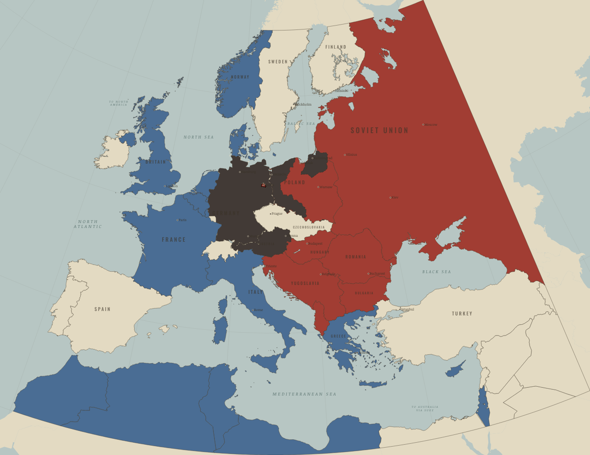
Map of refugees in Europe in May 1945
The Reich surrenders
Refugees in Europe in May 1945: The Reich surrenders. The map shows who held what: Soviet-occupied or communist, Western bloc or democracy, Germany and Austria occupied.
MAY 1945 · UPROOTED: REFUGEES IN EUROPE 1945–1960 AND INDOCHINA 1975–1990 These maps are reconstructed from published sources · Geoportal Berlin: official locality polygons · Berlin State Heritage Office: four sectors1945–1948 · Cliopatria v0.2.1 historical polities · Decolonization of Asia and Africa, 1945–1960 · Occupation and reconstruction of Germany, 1945–1948 · Natural Earth v5.1.2 country geography · Potsdam Protocol: administration and population transfers · UNHCR: The State of the World’s Refugees2000
Source details Geoportal Berlin / ALKIS Berlin Ortsteil. Datenlizenz Deutschland Zero2.0 Berlin State Heritage Office: four sectors1945–1948. Historical facts cited; no source artwork or text reproduced Cliopatria contributors / Seshat Global History Databank. CC BY 4.0 · Selected dated records; documented component selection, unions and shared-edge extraction. US Department of State, Office of the Historian. US government publication National Army Museum. Historical facts cited; no source artwork or prose reproduced Natural Earth contributors. Public domain · Full source components and holes retained; documented historical unions and repairs. Potsdam Protocol: administration and population transfers. Historical facts cited; no source artwork or text reproduced UNHCR: The State of the World’s Refugees2000. Historical facts cited; no source artwork or text reproduced Territories and displacement hatching are reconstructed from published source geometry. The hatched areas locate historical regions; ethnicity, displacement and control were not necessarily uniform at every point within them.
The layer records give the full source geometry and date choices. Arrows remain schematic routes, using the lesson’s existing volume categories.
Where a 1945 vector was unavailable, German occupation/state boundaries use the nearest 1949/1950 sources. Berlin’s sector-area reference uses official later locality boundaries, leaving small historical exchanges unresolved. The 1961 wall view uses actual 1989 wall segments as an explicitly later reference.
Prewar German, Polish, Finnish and Italian source polygons identify regions of transfer and expulsion. For Istria, the reference combines the published 1929–1939 Italian eastern outline and an IGM Fiume reconstruction with postwar Yugoslav geography. It shows the 1943–1956 exodus region, including the later 1954 Zone B adjustment. The 1947 peace treaty entered into force in September; the hatch does not show a treaty-day or April 1947 sovereignty line.
proxy: Later official city exterior · proxy: Natural Earth v5.1.2 geographic reference · reconstruction: 1937territories / postwar successor references · reconstruction: 1945–1947, near-date 1949 exterior reference · reconstruction: 1945–1991 · reconstruction: 1945–1991 geographic union · reconstruction: 1949/1950 · reconstruction: Postwar Yugoslav reference
Layer records and reconstruction methods
On the ground Pomerania, East Brandenburg and Silesia belonged to Germany in 1937 and were under Soviet occupation at the surrender East Prussia and the former Free City of Danzig were under Soviet occupation at the surrender The chapters of this moment
Related maps
◧ EMBED THIS MAP ON YOUR SITE
You may embed this map free if you keep the attribution link. Teachers can find print-ready
study guides at /study/ .
THE FREE PRINTABLE STUDY GUIDE
Get the printable study guide for Uprooted free. I’ll send you a few short letters, then one when a new atlas opens. That’s all. — Paul
NO TRACKING · YOUR ADDRESS IS USED FOR THE DISPATCH AND NOTHING ELSE ·
UNSUBSCRIBE ANYTIME