MAPS OF HISTORY · COUNTRIES · Kosovo14 ATLASES
History of Kosovo in maps
Kosovo as it appears in 14 interactive history atlases, from 264 BC to 2015: Dardania, Kosovo, Yugoslavia. Each era below lists who ruled the land and when control changed, linked to the dated map that shows it.
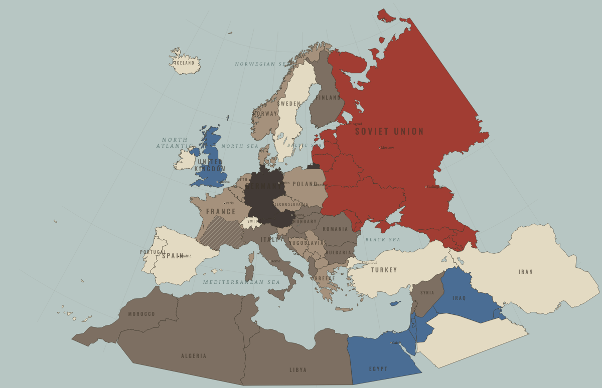
MAP OF EUROPE IN MAY 1941 These maps are reconstructed from published sources · Cliopatria v0.2.1 — dated political boundaries · French Ministry of the Armed Forces — La ligne de démarcation · Regional history institute — Italian annexations of1941, Fiume province and Krk · IGM Fiume, 1:25,000, sheet53B II SE — boundary established in1924 · Natural Earth — physical reference geography · Yugoslavia (1929–1939) location map — international frontier and Adriatic coast · Treaty of Rome (1924), division of Fiume and west-bank boundary · Murli / rowanwindwhistler — Slovakia border changes, 1938–1945 · United States Holocaust Memorial Museum — The Holocaust in Slovakia · Slovak Nation’s Memory Institute — The First Vienna Award
Source details Cliopatria contributors / Seshat Global History Databank. CC BY4.0 · Dated polity and constituent territory selections; campaign-dependent occupation overlays reconstructed separately. Ministère des Armées. Historical facts consulted; actual polygon imported from Cliopatria Regional history institute — Italian annexations of1941, Fiume province and Krk. Historical geographic facts consulted; source prose and artwork not republished Istituto Geografico Militare, Fiume (printed1946; 1927 survey with1931–1940 updates), reproduced by Istituto regionale per la storia della Resistenza e dell’Età contemporanea nel Friuli Venezia Giulia. Independent reconstruction from graticule coordinates and boundary observations; archive page reserves artwork rights.. Geographical-fact reconstruction; original archive artwork not distributed Natural Earth. Public domain NordNordWest/Wikipedia. Converted from the published SVG to WGS84; eastern Italian regional territory extracted. Source cites Velhagen & Klasings Großer Volksatlas (1938).. CC BY-SA 3.0 Germany 1924 agreement interpreted alongside the regional history institute and City of Rijeka’s explanation of the Donja/Gornja Drenova division.. Historical geographic facts; citation only Murli; SVG adaptation by rowanwindwhistler (2021). CC BY-SA 2.5; derived geographic paths under the same license · Georeferenced actual published vector regions using eight printed city positions; no map artwork or labels in the atlas. United States Holocaust Memorial Museum — The Holocaust in Slovakia. Historical chronology consulted; no source prose or artwork republished Slovak Nation’s Memory Institute — The First Vienna Award. Historical territorial chronology consulted; no source artwork or prose republished Slovak territory is reconstructed from the published 1938–1945 border-change map, which separates the client state from Hungarian and German annexations. This regional source does not resolve small northern frontier changes or survey-level detail. After August 1944, German military occupation supersedes the client-state fill.
The eastern Italian frontier uses the published 1930s regional map and a reconstruction of the 1924 Fiume boundary. Source conquests after April 1941 remain separately dated.
reconstruction: 1936–1941 · reconstruction: 1936–1942 · reconstruction: 1939–1944 · reconstruction: 1940–1941 · reconstruction: 1941.42 · reconstruction: 1941–1941 · reconstruction: 1941–1944 · vector: 1912–1955 · vector: 1936–1941 · vector: 1936–1944 · vector: 1936–1945 · vector: 1938–1972 · vector: 1939–1944 · vector: 1939–2023 · vector: 1940–1941 · vector: 1940–1942 · vector: 1940–1943 · vector: 1941–1941 · vector: 1941–1943 · vector: 1941–1944
Layer records and reconstruction methods
What was Kosovo before it was Kosovo? The sections below follow this
land through every era covered by the Maps of History atlases: who ruled it, what it was
called, and when control changed. Each line links to the dated map. Modern borders serve
as an approximation, as each atlas says on the map itself.
Dardania (mod. Kosovo) · Ancient Rome
264 BC Tribal peoples & confederations — the opening position AD 14 Roman territory
ANCIENT ROME: EVERY CHAPTER AND MAP →
Kosovo · Norse and Aztecs
c. 790 Other peoples and states — the opening position
NORSE AND AZTECS: EVERY CHAPTER AND MAP →
Kosovo · Crusades
1095 Byzantium (and Latin Constantinople 1204–61) — the opening position
CRUSADES: EVERY CHAPTER AND MAP →
Kosovo · Mongol Empire
1206 Other settled powers (Jin China, Christendom, Delhi) — the opening position
MONGOL EMPIRE: EVERY CHAPTER AND MAP →
Kosovo · Industrial Revolution
INDUSTRIAL REVOLUTION: EVERY CHAPTER AND MAP →
Kosovo · Age of Revolutions
JUL 1789 Neutral / uncommitted — the opening position
AGE OF REVOLUTIONS: EVERY CHAPTER AND MAP →
Yugoslavia (Kosovo) · Meiji Japan and post-Soviet Russia
OCT 1964 Non-aligned or stateless — the opening position
MEIJI JAPAN AND POST-SOVIET RUSSIA: EVERY CHAPTER AND MAP →
Kosovo (Serbia) · WWI
WWI: EVERY CHAPTER AND MAP →
Yugoslavia (Kosovo) · Stalin’s Soviet Union
Tito’s partisans fought German occupiers and their local allies from 1941 and took power in 1945 with little help from the Red Army. Yugoslavia had liberated itself, which helps explain why Tito could defy Moscow. He was initially more radical than Stalin wished, yet refused to take orders. Yugoslavia was expelled from the Cominform in June 1948. It survived Soviet pressure, accepted Western aid and built its own non-aligned communism, opening the first crack in the Soviet bloc.
STALIN’S SOVIET UNION: EVERY CHAPTER AND MAP →
Kosovo · Road to WW2
ROAD TO WW2: EVERY CHAPTER AND MAP →
Kosovo · WW2
WW2: EVERY CHAPTER AND MAP →
Kosovo · Cold War
AUG 1945 Soviet-aligned states — the opening position OCT 1949 Communist, outside Moscow’s bloc DEC 1991 In upheaval / changing sides MAY 1949 Communist, outside Moscow’s bloc DEC 1991 In upheaval / changing sides
COLD WAR: EVERY CHAPTER AND MAP →
Yugoslavia (Kosovo) · Feminism and the Tunisian Revolution
1945 Refused: women excluded; ERA never ratified — the opening position NOV 1961 Right won in law JAN 1972 Partial or unequal; treaty signed only; transition DEC 1972 No reform yet / outside this story DEC 1985 Right won in law
FEMINISM AND THE TUNISIAN REVOLUTION: EVERY CHAPTER AND MAP →
Yugoslavia (Kosovo) · Refugee crises
MAY 1945 Soviet-occupied or communist — the opening position
REFUGEE CRISES: EVERY CHAPTER AND MAP →
Related
THE FREE PRINTABLE STUDY GUIDE
Get a printable atlas study guide of your choice free. I’ll send you a few short letters, then one when a new atlas opens. That’s all. — Paul
NO TRACKING · YOUR ADDRESS IS USED FOR THE DISPATCH AND NOTHING ELSE ·
UNSUBSCRIBE ANYTIME