Norse and Aztecs · CHAPTER 1 ·
Medieval Warm Period and Little Ice Age
Chapter 1 of Climate and Innovation: The Norse and the Aztecs, c. 790–1521: “Climate as a Force in History”
Between about 950 and 1250 much of the North Atlantic enjoyed a warm spell scientists call the Medieval Climate Anomaly; from about 1275–1300 it slid into the colder Little Ice Age. Proxies such as Greenland ice cores and lake-mud records show the change was uneven, warming one coast while a neighbour cooled.
WW2 is free in full, and chapter 1 of every atlas is free. A free account opens 3 more chapters a day. Starter, at $9 a month, opens all 21 with no daily limit — see the plans.
Free printable Norse and Aztecs study guide, sent by email ↓
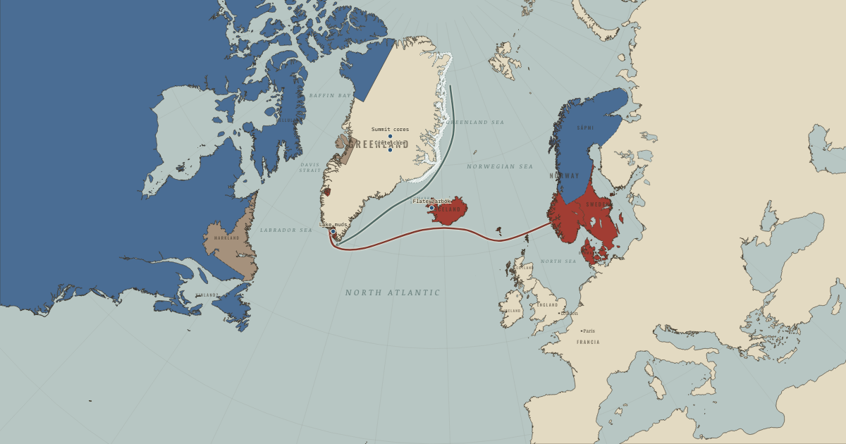
The map above is the world of The Norse North Atlantic, 1250 — Greenland at its height; the Thule Inuit arrive.
Part of IB History: The Norse and the Aztecs →
SHORT EXPLANATION
A Greenland farmer needed a summer long and moist enough to grow hay for cattle confined through winter. In central Mexico, Mexica farmers needed maize to ripen before frost, while their city faced drought and flooding in a lake basin with no outlet. These societies lived far apart and built different solutions to demanding environments. This atlas asks how those solutions worked, and why some endured while others failed.
Climate is the pattern of temperature, rain and ice over years; weather is what happens in a particular season. During the Medieval Climate Anomaly, roughly 950–1250, much of the North Atlantic was relatively warm. Colder centuries followed from about 1275–1300, the Little Ice Age, in contrast to the warming seen in the Arctic today. The Norse sailed west in the warmer period and later faced the cold. Their ships, sheep, seal hunting and assemblies belonged to one working system; Mexica dikes, raised fields and imperial tribute belonged to another. Ice cores, lake mud, tree rings and written accounts help us reconstruct the conditions each faced. The map's white band marks summer drift ice off east Greenland in the warm centuries, and red shows the Norse world at its height around 1250.
The full story
A warm period in one place need not be warm everywhere. Michael Mann and colleagues compared hundreds of records in 2009 and found that, between 950 and 1250, the North Atlantic was relatively warm while parts of the tropical Pacific were cool. The name Medieval Climate Anomaly describes such a regional departure from the usual pattern, rather as an unusually hot decade might stand out in a city's records.
Even Greenland offers different histories. Remains of midges in southern Scoop Lake suggest summers about 1.5 °C warmer in 900–1400 than in the colder centuries on either side. Farther north and inland, lakes near Kangerlussuaq record a drop of about 4 °C in roughly eighty years from around 1100. Gifford Miller's team dates the onset of a later cold period to 1275–1300: volcanic eruptions put sulphur into the atmosphere and dimmed sunlight, the team argues, while expanding sea ice prolonged the cooling. A record from one location cannot simply tell us what a neighboring community experienced.
How do we know about temperatures before thermometers? Scientists use proxies, natural records that preserve signs of past conditions. At Summit, the highest point of the Greenland ice sheet, the American GISP2 team drilled 3,053 metres to bedrock in 1989–93; the European GRIP core reached 3,028 metres in 1992. Snow from successive years remains in layers, and the proportion of a heavier form of oxygen varies with temperature. The ice thus preserves evidence from which past temperatures can be reconstructed.
Other records answer different questions. Lake muds provide evidence of rainfall, and tree rings can fix events to particular years. A burst of cosmic radiation left a signal in the ring for 993 that helped date Norse timber in Newfoundland. People left records too: Icelandic annals describe ice and hard winters, and Mexica chronicles report frosts and droughts in the 1450s that Mexican tree rings also support. Ice, wood and writing came into being in different ways; agreement among them gives an explanation firmer ground.
The comparison in this atlas begins with two different ways of making a home. The Norse, Scandinavian peoples of the Viking Age, settled Iceland in the 870s and Greenland in the 980s, reaching North America around 1000. Their history asks whether farming near its climatic limit could endure later change. The Mexica remained in one basin, using dikes, aqueducts and raised fields to manage a lake threatened by salt, flooding and frost. In each case inventions worked within a larger society: its population, food supply and trade shaped how much protection those inventions could provide.
FULL EXPLANATION
What the proxies can and cannot say
The Summit cores record air above an ice sheet more than 3,000 metres high. Norse farmers made hay in sheltered coastal fjords, and Antoon Kuijpers and colleagues warned in 2014 that the summit record may miss their maritime climate. William D’Andrea's lakes near Kangerlussuaq show sharp cooling from about 1100, but they too lie away from the farms, inland and farther north. A third record brings us closer: Lake 578 lies beside a homestead in the Eastern Settlement. Boyang Zhao and colleagues found in 2022 no substantial temperature change there during settlement, but persistent drying that could have reduced the hay crop. These records need not contradict one another. Temperature, rainfall and sea ice could change separately, and the place where a record was made determines which part of the Norse problem it can illuminate.
Sagas, annals and codices as climate data
A written account can describe what people noticed and suffered, but its author had a purpose besides preserving climate data. The Icelandic sagas were written down in the thirteenth and fourteenth centuries, at least two hundred years after the voyages; their fertile Greenland and mild Vinland may tell us something about their authors' world as well as Erik's. Annals are closer in time and report sea ice, famine and storms year by year. Even so, Astrid Ogilvie and colleagues argued in 2009 that the sentence about ice forcing Greenland sailors from an old route was inserted later into Ívar Bárðarson's fourteenth-century description. In Mexico, Diego Durán and other chroniclers wrote after the Spanish conquest and gave the famine of the 1450s a moral meaning. Their account of drought gains independent support from the Mexican Drought Atlas, published by David Stahle's team in 2016: tree rings show a great central Mexican drought in 1452–54. The trees help test the event; the chronicles also show how later writers interpreted it.
Climate determinism and its critics
Was Greenland's climate responsible for the Norse departure, or did the colonists bring disaster on themselves? Willi Dansgaard's team compared the Crête ice core with Norse history in 1975 and suggested a strong climatic impact. Jared Diamond's Collapse (2005) emphasized choices: in his account the Norse damaged their soils, held to cattle and churches, and refused to learn from the Inuit. Andrew Dugmore, Thomas McGovern and colleagues proposed a different explanation in 2012. They described a flexible and successful colony whose earlier success also created weaknesses; cooling, falling trade and isolation then came together to expose them. Most specialists now reject explanations resting on climate alone or on folly alone. The Mexica case raises a related issue. Hydraulic works sustained a larger lake city, yet the concentration of people also increased exposure when the lake turned against it. To explain an outcome we must ask both what pressure arrived and how the society had become vulnerable to it.
Key places on the map
On this day
Why it happened
Living at the margin magnifies small changes. Hay linked Greenland's short summer to the survival of cattle through eight winter months. Too little warmth or moisture could leave the animals without enough feed. Mexica maize faced a different limit at about 2,240 metres: an early autumn frost could kill the crop before it ripened. Near such limits a shift of a degree or two could turn an ordinary harvest into a desperate year.
Ocean currents and sea ice shape the routes. Ships connected Greenland to Norway, but the sea also carried an obstacle. The cold East Greenland Current, shown by the grey arrow, moves Arctic ice down the east coast and around Cape Farewell. As cooling made drift ice more extensive and longer-lasting in summer, harbors could be blocked and voyages stretched out. The connection became slower and riskier just as the settlements depended on it.
Volcanoes can tip a climate into a new state. Sulphur from a large eruption can reach high into the atmosphere, reflect sunlight and cool the world for several years. Gifford Miller's team argued in 2012 that four large eruptions over roughly fifty years helped initiate the Little Ice Age in 1275–1300; the sequence included the 1257–58 eruption later traced to Samalas in Indonesia. Expanding sea ice could then reflect more sunlight, keeping summers cold after the volcanic haze had cleared.
Societies build their own vulnerabilities. A settlement of perhaps 2,000–2,500 people in Norse Greenland had a small margin against repeated bad years. Tenochtitlan, perhaps 200,000 strong, could draw on an empire for food, but placed a large population on one lake. Population, food diversity and trade determined what resources each society had when cold or drought struck. A shock that one community survived could be fatal to another.
THE TURNING POINT
Summit, Greenland, 1 July 1993. On 1 July 1993 the GISP2 drill reached bedrock 3,053 metres beneath the Greenland ice sheet's summit. Its core offered an almost year-by-year climate record independent of the sagas and annals. That independence mattered: if historians inferred climate from the same documents whose history they wanted climate to explain, the argument risked becoming circular. Ice and documents could now be compared, although conditions high at Summit still needed to be related carefully to those on coastal farms.
What it changed
The warm centuries open the sea road. Norse voyages to Iceland, Greenland and North America coincided with the relatively warm centuries of roughly 950–1250. Climate helped set the conditions for open-ocean crossings; ships and the farming society that supported them made the voyages possible. Chapter 2 takes up that combination.
The cold tests the farms. Greenland's outlying farms depended on hay and cattle, while walrus ivory supported trade. Cooling after about 1275–1300 placed those arrangements under pressure. Chapter 5 weighs that pressure with markets, isolation and choice in asking why the Norse left while newly arrived Inuit stayed and prospered.
A second laboratory in Mexico. The Basin of Mexico faced floods in 1449 and 1499 and frost and drought in the 1450s. Chapter 8 examines dikes, aqueducts and granaries as Mexica responses. By supporting a larger population on the lake, those measures also meant that a later failure could harm more people.
DISCUSSION QUESTION — Can climate ever be the cause of a society’s success or failure, or only its context?
Climate can cause a change without explaining the outcome by itself. Warmer centuries widened the opportunity for farming in Norse Greenland; cooling after 1275–1300 narrowed it. Yet Iceland endured the colder period, and Thule Inuit expanded into Greenland while the Norse withdrew. Different food and tools made survival possible under cold conditions. Even the evidence of physical change differs by location: Lake 578 records drying near a farm, while the summit cores record conditions high above the settlements. Historians study vulnerability by asking how population, trade, technology and choices exposed people to a pressure or helped them withstand it. The same shock could be an inconvenience to one society and a catastrophe to another.
An interesting fact
A beer bottle helped give scientists a way to read ancient temperatures in ice. On a rainy Saturday at the end of June 1952, Danish physicist Willi Dansgaard set an empty bottle and funnel in his garden at Herlev, near Copenhagen, and collected successive showers. The proportion of heavy oxygen in the rain varied with the temperature of the cloud from which it fell. Dansgaard reasoned that, if snow retained the same signature, Greenland's ice sheet could preserve a temperature record. Two decades later he read that record alongside the history of the Greenland Norse.
Related
THE FREE PRINTABLE STUDY GUIDE
Get the printable study guide for Climate and Innovation free. I’ll send you a few short letters, then one when a new atlas opens. That’s all. — Paul
NO TRACKING · YOUR ADDRESS IS USED FOR THE DISPATCH AND NOTHING ELSE · UNSUBSCRIBE ANYTIME