MAPS OF HISTORY · WWI · MAPS BY YEAR · December 1915The Great War, 1871–1923 · THE MAP IN DEC 1915
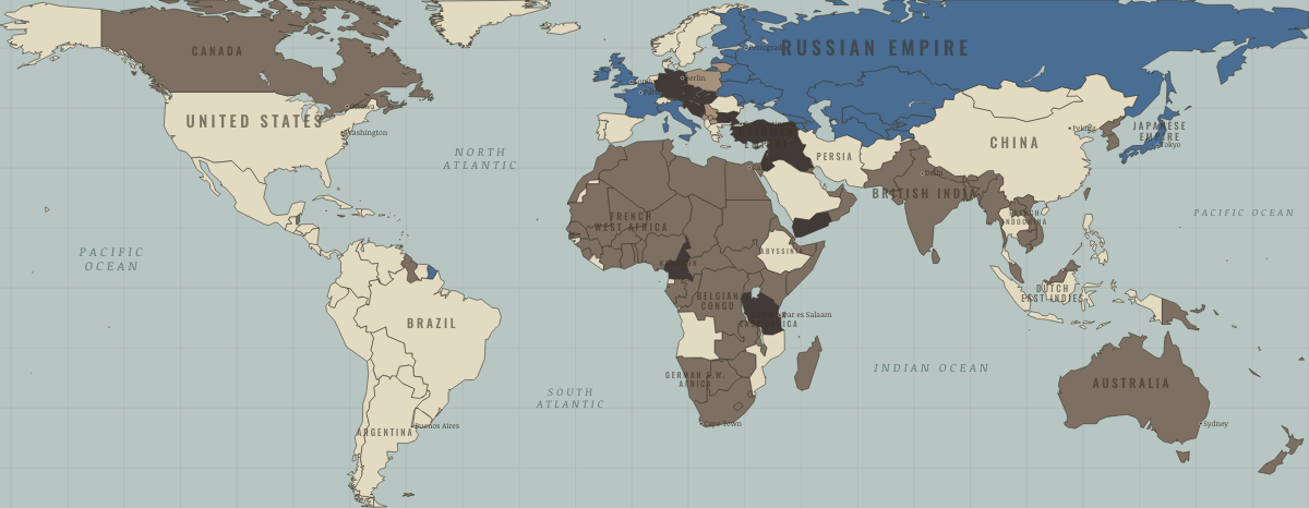
Map of the world in December 1915
The colonial campaigns · WWI
The world in December 1915: The colonial campaigns. Since November 1914, 11 territories changed status on this map: including Italy, Libya, Eritrea and 8 more.
DEC 1915 · THE GREAT WAR, 1871–1923 These maps are reconstructed from published sources · Cliopatria v 0.2.1 · Natural Earth physical geography
Source details Cliopatria contributors / Seshat Global History Databank. Source polygons retained with original identities; geographic selections and corrections by Maps of History.. CC BY 4.0 Made with Natural Earth; geographic reference and physical land only. No modern political boundary is used as a historical boundary.. Public domain Annual source features can describe claims, legal territory or military control. Occupied extensions are separated from the prewar Central Power homelands, while the original source names and shapes remain available.
reconstruction: 1915 · vector: 1815–1937 · vector: 1840–1978 · vector: 1848–1935 · vector: 1864–1921 · vector: 1865–1915 · vector: 1866–2023 · vector: 1871–1916 · vector: 1877–1935 · vector: 1877–2023 · vector: 1885–1925 · vector: 1890–1978 · vector: 1890–2023 · vector: 1895–1917 · vector: 1895–1941 · vector: 1895–1978 · vector: 1898–2023 · vector: 1900–1918 · vector: 1900–1986 · vector: 1905–1915 · vector: 1905–1921 · vector: 1905–1923 · vector: 1905–1925 · vector: 1905–1927 · vector: 1905–1928 · vector: 1905–1942 · vector: 1905–1949 · vector: 1905–1999 · vector: 1908–1916 · vector: 1908–1931 · vector: 1908–1935 · vector: 1911–1915 · vector: 1911–1925 · vector: 1911–1929 · vector: 1912–1915 · vector: 1912–1919 · vector: 1912–1921 · vector: 1912–1955 · vector: 1913–1915 · vector: 1913–1918 · vector: 1913–1919 · vector: 1914–1915 · vector: 1914–1916 · vector: 1914–1938 · vector: 1915–1915 · vector: 1915–1916 · vector: 1915–1918 · vector: 1915–1921 · vector: 1915–1940
Layer records and reconstruction methods
What changes on the map Italy — → The Entente & Allies Libya — → Entente-aligned & imperial territories Eritrea — → Entente-aligned & imperial territories German South-West Africa Germany and its allies — the Central Powers → Entente-aligned & imperial territories Bulgaria — → Germany and its allies — the Central Powers Serbia The Entente & Allies → Under Central Powers occupation Macedonia (Serbia) The Entente & Allies → Under Central Powers occupation Kosovo (Serbia) The Entente & Allies → Under Central Powers occupation Montenegro The Entente & Allies → Under Central Powers occupation Poland (partitioned) The Entente & Allies → Under Central Powers occupation Lithuania (Russian Empire) The Entente & Allies → Under Central Powers occupation
Related maps
◧ EMBED THIS MAP ON YOUR SITE
You may embed this map free if you keep the attribution link. Teachers can find print-ready
study guides at /study/ .
THE FREE PRINTABLE STUDY GUIDE
Get the printable study guide for WWI free. I’ll send you a few short letters, then one when a new atlas opens. That’s all. — Paul
NO TRACKING · YOUR ADDRESS IS USED FOR THE DISPATCH AND NOTHING ELSE ·
UNSUBSCRIBE ANYTIME