MAPS OF HISTORY · WW2 · MAPS BY YEAR · May 1941The War Room — WW2, 1936–1945 · THE MAP IN MAY 1941
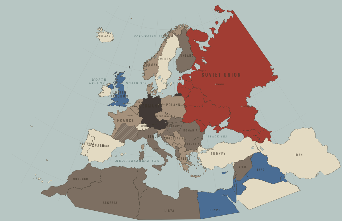
Map of Europe in May 1941
The Balkans overrun · WW2
Europe in May 1941: The Balkans overrun. Since June 1940, 12 territories changed status on this map: including Serbia, Slovenia, Bosnia and Herzegovina and 9 more.
MAY 1941 · THE WAR ROOM — WW2, 1936–1945 These maps are reconstructed from published sources · Cliopatria v0.2.1 — dated political boundaries · French Ministry of the Armed Forces — La ligne de démarcation · Regional history institute — Italian annexations of1941, Fiume province and Krk · IGM Fiume, 1:25,000, sheet53B II SE — boundary established in1924 · Natural Earth — physical reference geography · Yugoslavia (1929–1939) location map — international frontier and Adriatic coast · Treaty of Rome (1924), division of Fiume and west-bank boundary · Murli / rowanwindwhistler — Slovakia border changes, 1938–1945 · United States Holocaust Memorial Museum — The Holocaust in Slovakia · Slovak Nation’s Memory Institute — The First Vienna Award
Source details Cliopatria contributors / Seshat Global History Databank. CC BY4.0 · Dated polity and constituent territory selections; campaign-dependent occupation overlays reconstructed separately. Ministère des Armées. Historical facts consulted; actual polygon imported from Cliopatria Regional history institute — Italian annexations of1941, Fiume province and Krk. Historical geographic facts consulted; source prose and artwork not republished Istituto Geografico Militare, Fiume (printed1946; 1927 survey with1931–1940 updates), reproduced by Istituto regionale per la storia della Resistenza e dell’Età contemporanea nel Friuli Venezia Giulia. Independent reconstruction from graticule coordinates and boundary observations; archive page reserves artwork rights.. Geographical-fact reconstruction; original archive artwork not distributed Natural Earth. Public domain NordNordWest/Wikipedia. Converted from the published SVG to WGS84; eastern Italian regional territory extracted. Source cites Velhagen & Klasings Großer Volksatlas (1938).. CC BY-SA 3.0 Germany 1924 agreement interpreted alongside the regional history institute and City of Rijeka’s explanation of the Donja/Gornja Drenova division.. Historical geographic facts; citation only Murli; SVG adaptation by rowanwindwhistler (2021). CC BY-SA 2.5; derived geographic paths under the same license · Georeferenced actual published vector regions using eight printed city positions; no map artwork or labels in the atlas. United States Holocaust Memorial Museum — The Holocaust in Slovakia. Historical chronology consulted; no source prose or artwork republished Slovak Nation’s Memory Institute — The First Vienna Award. Historical territorial chronology consulted; no source artwork or prose republished Slovak territory is reconstructed from the published 1938–1945 border-change map, which separates the client state from Hungarian and German annexations. This regional source does not resolve small northern frontier changes or survey-level detail. After August 1944, German military occupation supersedes the client-state fill.
The eastern Italian frontier uses the published 1930s regional map and a reconstruction of the 1924 Fiume boundary. Source conquests after April 1941 remain separately dated.
reconstruction: 1936–1941 · reconstruction: 1936–1942 · reconstruction: 1939–1944 · reconstruction: 1940–1941 · reconstruction: 1941.42 · reconstruction: 1941–1941 · reconstruction: 1941–1944 · vector: 1912–1955 · vector: 1936–1941 · vector: 1936–1944 · vector: 1936–1945 · vector: 1938–1972 · vector: 1939–1944 · vector: 1939–2023 · vector: 1940–1941 · vector: 1940–1942 · vector: 1940–1943 · vector: 1941–1941 · vector: 1941–1943 · vector: 1941–1944
Layer records and reconstruction methods
What changes on the map
The chapters of this moment
Related maps
◧ EMBED THIS MAP ON YOUR SITE
You may embed this map free if you keep the attribution link. Teachers can find print-ready
study guides at /study/ .
THE FREE PRINTABLE STUDY GUIDE
Get the printable study guide for WW2 free. I’ll send you a few short letters, then one when a new atlas opens. That’s all. — Paul
NO TRACKING · YOUR ADDRESS IS USED FOR THE DISPATCH AND NOTHING ELSE ·
UNSUBSCRIBE ANYTIME