The Great War, 1871–1923 · THE MAP IN
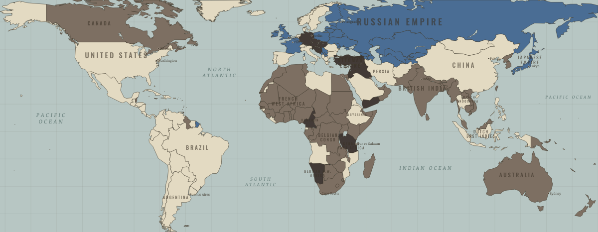
Map of the world in November 1914
A world of empires at war · WWI
The world in November 1914: A world of empires at war. The map shows who held what: Entente-aligned & imperial territories, The Entente & Allies, Germany and its allies — the Central Powers.
Open this map in the interactive atlas →
WW2 is free in full, and chapter 1 of every atlas is free. A free account opens 3 more chapters a day. Starter, at $9 a month, opens all 21 with no daily limit — see the plans.
What changes on the map
| Belgium | — → The Entente & Allies |
| Japan | — → The Entente & Allies |
| South Korea | — → Entente-aligned & imperial territories |
| North Korea | — → Entente-aligned & imperial territories |
| Taiwan | — → Entente-aligned & imperial territories |
| Belgian Congo | — → Entente-aligned & imperial territories |
| Ottoman Empire | — → Germany and its allies — the Central Powers |
| Syria (Ottoman Empire) | — → Germany and its allies — the Central Powers |
| Lebanon (Ottoman Empire) | — → Germany and its allies — the Central Powers |
| Palestine (Ottoman Empire) | — → Germany and its allies — the Central Powers |
| Palestine (Ottoman Empire) | — → Germany and its allies — the Central Powers |
| Transjordan (Ottoman Empire) | — → Germany and its allies — the Central Powers |
| Mesopotamia (Ottoman Empire) | — → Germany and its allies — the Central Powers |
| Yemen | — → Germany and its allies — the Central Powers |
| Togoland (German) | Germany and its allies — the Central Powers → Entente-aligned & imperial territories |
| New Guinea (German/Australian) | Germany and its allies — the Central Powers → Entente-aligned & imperial territories |
Related maps
THE FREE PRINTABLE STUDY GUIDE
Get the printable study guide for WWI free. I’ll send you a few short letters, then one when a new atlas opens. That’s all. — Paul
NO TRACKING · YOUR ADDRESS IS USED FOR THE DISPATCH AND NOTHING ELSE · UNSUBSCRIBE ANYTIME