WW2 · CHAPTER 11 ·
Pacific island-hopping campaign
Chapter 11 of The War Room — WW2, 1936–1945: “The Island Road”
The Allied Pacific counteroffensive began at Guadalcanal in August 1942. MacArthur advanced through New Guinea and Nimitz across the Central Pacific, leapfrogging strongholds such as Rabaul, while US submarines sank much of Japan’s merchant fleet. At Leyte Gulf in October 1944 much of Japan’s remaining fleet was destroyed.
WW2 is free — every chapter. No sign-up.
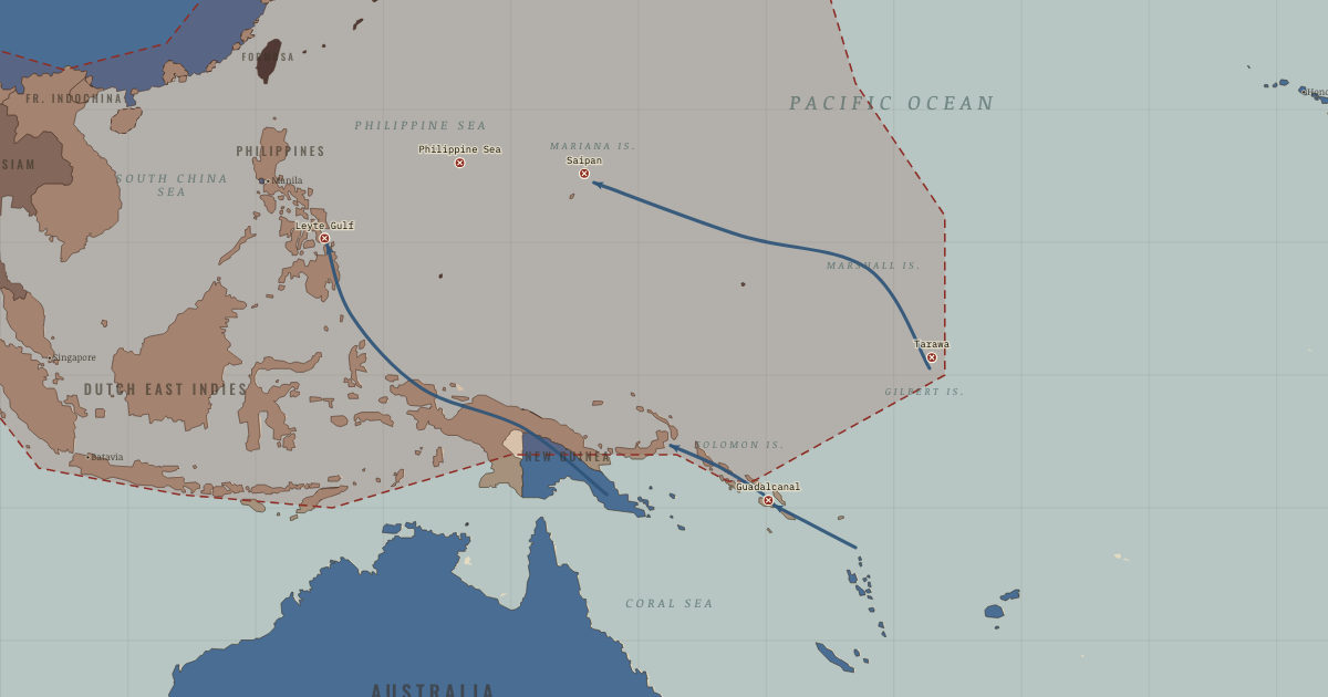
The map above is the world of Asia and the Pacific, February 1943 — The tide checks.
Every state on the map that year: The world in 1942 · Europe in 1942.
Part of IB History: The Second World War →
SHORT EXPLANATION
The Allied return across the Pacific began at Guadalcanal in 1942. From there General MacArthur moved along New Guinea toward the Philippines, while Admiral Nimitz advanced across the Central Pacific. Their forces did not have to take every Japanese base: a stronghold such as Rabaul could be cut off and left behind.
The Allies called this method leapfrogging. An island with a useful airfield or anchorage became a base for the next move; a garrison left without supplies lost much of its power to interfere. American submarines meanwhile attacked the merchant ships carrying resources to Japan. By the Battle of Leyte Gulf in October 1944, much of the remaining Japanese fleet had been destroyed as an effective offensive force, and the perimeter was becoming a chain of isolated garrisons.
The full story
The fighting at Guadalcanal showed both what an Allied advance could achieve and what it might cost. Beginning in August 1942, the first sustained Allied ground offensive of the Pacific war drew men, ships and aircraft from both sides into six months of fighting. Tropical disease added enormously to the losses. When Japan evacuated the island in February 1943, the Allies had pushed back its perimeter. Yet a campaign that required a similar struggle for every defended island would be terribly expensive.
The alternative was leapfrogging. Planners selected positions that could support aircraft, ships and supplies for a further advance, while air and naval power isolated other strongholds. Rabaul retained its large Japanese garrison, but that garrison could no longer exercise its former influence on the campaign. The choice of an objective mattered: an airfield might put the next target within range, or an anchorage provide shelter for ships. An island that could be neutralized from the air might offer too little to justify the casualties of taking it.
Two advances carried this strategy forward. MacArthur's forces moved along the New Guinea coast toward the Philippines; Nimitz's drove through the Central Pacific toward the Marianas. Their rivalry wasted some effort, but Japan also had to prepare for attacks on several possible routes. Behind the arrows lay tankers, repair ships, engineers and protected convoys, without which the captured positions could not support a further move. Japan could fortify islands, but it could neither supply them all nor know which one would be attacked next.
American submarines attacked the merchant shipping that linked Japan to the resources it had conquered. The loss of that shipping weakened the connections on which the empire depended. From the Marianas, B-29 bombers could strike Japan itself; the return to the Philippines cut into the southern resource routes. At Leyte Gulf in October 1944, much of Japan's remaining fleet was destroyed as an effective offensive force. The perimeter was no longer a working network of mutually supporting positions.
FULL EXPLANATION
The supply chain across the ocean
An island captured in the middle of the Pacific was useful only if the forces using it could be supplied. Fuel, food, medical care, repairs and shipping all had to follow the fighting forces forward. The United States built mobile bases for that purpose. Fleet oilers supplied ships, floating dry docks repaired them, and Seabee construction units turned selected islands into airfields and anchorages. The fleet could operate near the front without making every journey back to a distant fixed base. Japan lacked comparable merchant shipping, escorts and repair capacity. American submarines sank more than half its merchant marine, making the problem worse. Japan had conquered territory partly to secure resources, but those resources had to travel by sea to its factories and forces. Once the ships were lost, possession of the territory could not provide the same power. The map's shrinking perimeter is only part of the story; the sea lanes connecting its positions mattered too.
The work of bypassing a fortress
To bypass a fortress, the Allies first had to make it difficult for the garrison to intervene. Aircraft and ships suppressed its air power and cut off resupply. An isolated garrison could then consume Japanese resources without stopping the advance, while the Allies avoided the casualties of an assault. The people left behind paid a price: Japanese troops and nearby civilians suffered hunger, disease and isolation. Bypassing was a choice made for particular places, not a rule that settled every case. Tarawa and Saipan, and later Iwo Jima and Okinawa, were judged worth assaulting, and the fighting was terrible. Commanders weighed aircraft range and anchorages against expected losses, as well as political commitments. MacArthur's return to the Philippines had political as well as strategic reasons; alternatives were seriously debated.
Key places on the map
On this day
Why it happened
Distance and supply. A Pacific offensive needed support over immense distances. Tankers carried fuel, floating dry docks repaired ships, and Seabee battalions built airfields. America's mobile fleet-base system brought that support forward. Japan's garrisons depended on sea routes too, but without a comparable system they went short as those routes became vulnerable.
Two routes across the Pacific. MacArthur's Army-led advance in the southwest and Nimitz's Navy-led drive through the center reflected rivalry between the services. Maintaining parallel offensives could waste effort, yet it also confronted Japan with several possible directions of attack. Defenders could not know in advance which position would be chosen.
The submarine campaign. Japan's island empire depended on ships to carry imported resources. American submarines sank more than half its merchant marine, steadily reducing the capacity to make those journeys. By 1945 the blockade was a major part of the pressure on Japan.
THE TURNING POINT
Guadalcanal, August 1942–February 1943. Guadalcanal drew both sides into six months of fighting on land, at sea and in the air. Japan's evacuation in February 1943 gave the Allies territory back, but the struggle also showed the determination of Japanese defenders and the importance of American production and replacement capacity. Both would shape the campaigns through 1945.
What it changed
A shrinking perimeter. The red line retreats as the Allies take the Gilberts, Marshalls and Marianas in sequence. Each captured position helps expose the next. Behind that moving front, hundreds of thousands of men in bypassed garrisons face shortages and isolation; some grow food while waiting for relief.
The Marianas and Japan. The Marianas offered a base from which B-29 bombers could reach Tokyo. Their loss in June 1944 also contributed to the fall of General Tojo's government. The islands became a starting point for the endgame.
India and Burma. Japan's invasion of India was defeated at Imphal and Kohima in spring 1944 by Allied forces including Indian divisions. The defeat helped turn the fighting toward Burma and exposed the limits of Japan's claim to be Asia's liberator.
DISCUSSION QUESTION — Why isolate a fortress such as Rabaul, with its roughly 100,000-man garrison, instead of assaulting it?
The roughly 100,000 men at Rabaul could not make their strength count against the advance once Allied air and sea power suppressed their aircraft and cut supply, movement and communications. Assaulting them would risk heavy casualties for a position the Allies could leave behind. The comparison with Stalingrad is structural: a strongpoint depends on the system supporting it.
An interesting fact
In the Solomons on 2 August 1943, a Japanese destroyer struck the torpedo boat PT-109. Its 26-year-old skipper, John F. Kennedy, helped a burned crewman toward an islet, towing him by a life-jacket strap clenched in his teeth. Two Solomon Islander scouts working with Allied coastwatchers, Biuku Gasa and Eroni Kumana, found the survivors. They carried a rescue message carved into a coconut husk through Japanese-held waters. Kennedy later kept the coconut on his Oval Office desk; it is displayed at his presidential library.
Related
THE FREE PRINTABLE STUDY GUIDE
Get the printable study guide for WW2 free. I’ll send you a few short letters, then one when a new atlas opens. That’s all. — Paul
NO TRACKING · YOUR ADDRESS IS USED FOR THE DISPATCH AND NOTHING ELSE · UNSUBSCRIBE ANYTIME