MAPS OF HISTORY · MONGOL EMPIRE · MAPS BY YEAR · 1221The Mongol Empire, 1206–1294 · THE MAP IN 1221
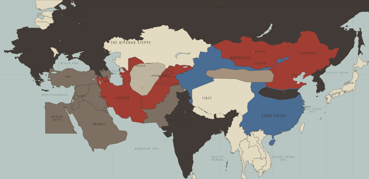
Map of the Mongol Empire in 1221
Khwarazm annihilated
The Mongol Empire in 1221: Khwarazm annihilated. Since 1215, 6 territories changed status on this map: including Persia (Khwarazm, then Ilkhanate), Khwarazm & Khorasan (mod. Turkmenistan), Transoxiana (mod. Uzbekistan) and 3 more.
1221 · THE MONGOL EMPIRE, 1206–1294 These maps are reconstructed from published sources · Cliopatria v0.2.1 — historical political boundaries · Peter Jackson, Encyclopaedia Iranica — Mongols · Natural Earth — physical reference geography
Source details Cliopatria contributors / Seshat Global History Databank. CC BY 4.0 · Selected dated polygons; documented unions, differences and shared edges for event-specific reconstructions; projected for display. Peter Jackson / Encyclopaedia Iranica. Historical facts consulted; thematic geometry independently reconstructed Natural Earth. Public domain The source stage comes later than the conquest of Khorasan. A regional patch anchored to cities transfers the documented conquest corridor within the later Mongol outline; its inferred edge is disclosed.
reconstruction: 1169–1226 · reconstruction: 1188–1235 · reconstruction: 1202–1249 · reconstruction: 1206–1226 · reconstruction: 1210–1226 · reconstruction: 1210–1235 · reconstruction: 1210–1240 · reconstruction: 1216–1226 · reconstruction: 1216–1235 · reconstruction: 1219–1221 · reconstruction: 1220–1226 · reconstruction: 1220–1235 · reconstruction: 1221 · vector: 1056–1249 · vector: 1072–1226 · vector: 1072–1235 · vector: 1072–1249 · vector: 1072–1325 · vector: 1072–1374 · vector: 1094–1235 · vector: 1099–1226 · vector: 1111–1278 · vector: 1126–1226 · vector: 1139–1226 · vector: 1139–1235 · vector: 1139–1240 · vector: 1139–1259 · vector: 1152–1235 · vector: 1169–1226 · vector: 1169–1235 · vector: 1188–1240 · vector: 1188–1259 · vector: 1188–1271 · vector: 1188–1284 · vector: 1188–1304 · vector: 1192–1235 · vector: 1192–1325 · vector: 1192–1362 · vector: 1202–1235 · vector: 1202–1240 · vector: 1202–1249 · vector: 1202–1259 · vector: 1202–1374 · vector: 1202–1743 · vector: 1206–1235 · vector: 1206–1240 · vector: 1210–1226 · vector: 1210–1249 · vector: 1210–1304 · vector: 1216–1226 · vector: 1216–1235 · vector: 1216–1240 · vector: 1216–1249 · vector: 1220–1226 · vector: 1220–1235 · vector: 1220–1240 · vector: 1220–1249 · vector: 1220–1313 · vector: 602–1501 · vector: 936–1271
Layer records and reconstruction methods
What changes on the map
On the ground The belt of Khwarazmian cities was sacked and depopulated in 1219–21. The chapters of this moment
Related maps
◧ EMBED THIS MAP ON YOUR SITE
You may embed this map free if you keep the attribution link. Teachers can find print-ready
study guides at /study/ .
THE FREE PRINTABLE STUDY GUIDE
Get the printable study guide for The Mongol Empire free. I’ll send you a few short letters, then one when a new atlas opens. That’s all. — Paul
NO TRACKING · YOUR ADDRESS IS USED FOR THE DISPATCH AND NOTHING ELSE ·
UNSUBSCRIBE ANYTIME