MAPS OF HISTORY · MONGOL EMPIRE · MAPS BY YEAR · 1215The Mongol Empire, 1206–1294 · THE MAP IN 1215
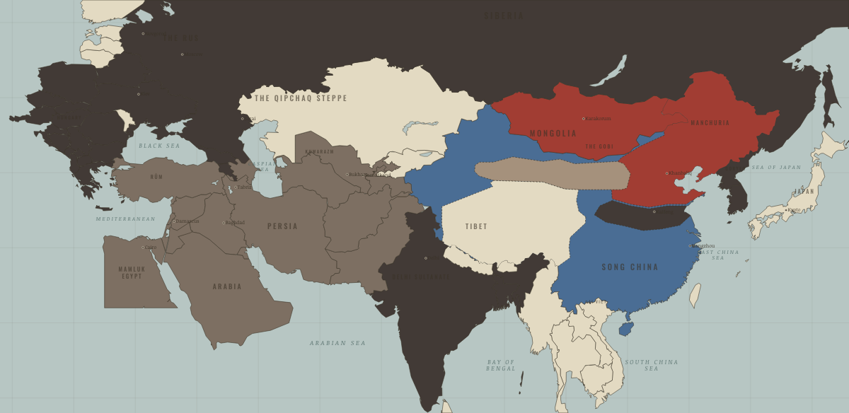
Map of the Mongol Empire in 1215
Zhongdu falls
The Mongol Empire in 1215: Zhongdu falls. The map shows who held what: Other settled powers (Jin China, Christendom, Delhi), The Islamic powers, The Mongol Empire.
1215 · THE MONGOL EMPIRE, 1206–1294 These maps are reconstructed from published sources · Cliopatria v0.2.1 — historical political boundaries · Asia for Educators, Columbia University — Three Invasions Led by Chinggis · Natural Earth — physical reference geography
Source details Cliopatria contributors / Seshat Global History Databank. CC BY 4.0 · Selected dated polygons; documented unions, differences and shared edges for event-specific reconstructions; projected for display. Asia for Educators, Columbia University. Text consulted for historical facts; no map or prose copied Natural Earth. Public domain For the capture of Zhongdu, the 1216–1219 Mongol geometry supplies only the portion transferred from the 1206–1215 Jin outline. The remainder of Jin territory uses the closest record, dated 1216–1226.
proxy: 1216–1226 · reconstruction: 1169–1226 · reconstruction: 1188–1235 · reconstruction: 1202–1215 · reconstruction: 1202–1219 · reconstruction: 1202–1249 · reconstruction: 1206–1226 · reconstruction: 1210–1215 · reconstruction: 1210–1219 · reconstruction: 1210–1226 · reconstruction: 1210–1235 · reconstruction: 1210–1240 · reconstruction: 1215 · reconstruction: 1216–1226 · vector: 1056–1249 · vector: 1072–1226 · vector: 1072–1235 · vector: 1072–1249 · vector: 1072–1325 · vector: 1072–1374 · vector: 1094–1235 · vector: 1099–1226 · vector: 1111–1278 · vector: 1126–1226 · vector: 1139–1215 · vector: 1139–1226 · vector: 1139–1235 · vector: 1139–1240 · vector: 1139–1259 · vector: 1152–1235 · vector: 1169–1226 · vector: 1169–1235 · vector: 1177–1215 · vector: 1188–1219 · vector: 1188–1240 · vector: 1188–1259 · vector: 1188–1271 · vector: 1188–1284 · vector: 1188–1304 · vector: 1192–1235 · vector: 1192–1325 · vector: 1192–1362 · vector: 1202–1219 · vector: 1202–1235 · vector: 1202–1240 · vector: 1202–1249 · vector: 1202–1259 · vector: 1202–1374 · vector: 1202–1743 · vector: 1206–1215 · vector: 1206–1219 · vector: 1206–1235 · vector: 1206–1240 · vector: 1210–1215 · vector: 1210–1219 · vector: 1210–1226 · vector: 1210–1249 · vector: 1210–1304 · vector: 602–1501 · vector: 936–1271
Layer records and reconstruction methods
On the ground Mongol forces have occupied the land north of the Yellow River since 1215. Between 1215 and 1234, the surviving Jin state holds Henan and rules from Kaifeng. From 1210 to 1226, Xi Xia remains under Mongol authority as a reluctant vassal. The chapters of this moment
Related maps
◧ EMBED THIS MAP ON YOUR SITE
You may embed this map free if you keep the attribution link. Teachers can find print-ready
study guides at /study/ .
THE FREE PRINTABLE STUDY GUIDE
Get the printable study guide for The Mongol Empire free. I’ll send you a few short letters, then one when a new atlas opens. That’s all. — Paul
NO TRACKING · YOUR ADDRESS IS USED FOR THE DISPATCH AND NOTHING ELSE ·
UNSUBSCRIBE ANYTIME