MAPS OF HISTORY · MONGOL EMPIRE · BATTLES AND EVENTS · Battle of Bạch ĐằngMongol Empire · BATTLE SITE · 1288
Battle of Bạch Đằng (1288)
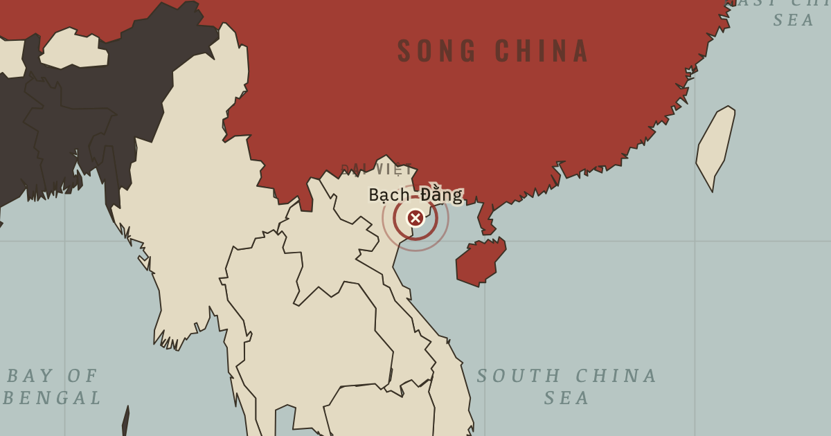
On the Mongol Empire map as “Bạch Đằng”
Apr 1288 — Trần Hưng Đạo plants iron-tipped stakes in the river mouth and lures the Yuan fleet in at high tide. When the water ebbs, the ships are impaled on the stakes. Đại Việt has endured three invasions, using scorched earth and ambush as well as the heat, and remains unconquered. Vietnam remembers the victory.
When Apr 1288 Type Battle site Chapter Mongol invasions of Japan and Vietnam (chapter 11 of Mongol Empire)Atlas The Mongol Empire, 1206–1294 BATTLE SITE · THE MONGOL EMPIRE, 1206–1294 These maps are reconstructed from published sources · Cliopatria v0.2.1 — historical political boundaries · Asia for Educators — Expansion under Ögödei · Asia for Educators — Military Successes and Failures · Asia for Educators — Collapse of the Empire and Four Sectors · Natural Earth — physical reference geography · Janet Martin — Medieval Russia 980–1584, chronology · Institute of History of Ukraine — Mongol invasion and its consequences
Source details Cliopatria contributors / Seshat Global History Databank. CC BY 4.0 · Selected dated polygons; documented unions, differences and shared edges for event-specific reconstructions; projected for display. Asia for Educators, Columbia University. Text consulted for historical facts; no map or prose copied Asia for Educators, Columbia University. Text consulted for historical facts; no map or prose copied Asia for Educators, Columbia University. Text consulted for historical facts; no map or prose copied Natural Earth. Public domain Janet Martin, Cambridge University Press. Historical facts consulted; no map or prose copied Encyclopedia of the History of Ukraine, 2019. Historical facts consulted; thematic geometry independently reconstructed The dashed internal divisions use Cliopatria’s earliest separate successor-khanate polygons (1294), restricted to the dated empire extent. Earlier divisions are reconstructed regional references.
Published polity extents are used at the date resolution available in their sources. Hatched affected regions and route arrows are educational reconstructions; the source details distinguish them from imported boundaries.
proxy: 1206 reference extent · proxy: 1294 successor-polity reference · proxy: Goryeo 1227–1259 territorial reference · reconstruction: 1250–1284 · reconstruction: 1260–1284 · reconstruction: 1260–1313 · reconstruction: 1272–1284 · reconstruction: 1272–1304 · reconstruction: 1279–1284 · reconstruction: 1279–1293 · reconstruction: 1281 · reconstruction: 1281; regional outlines from pre-conquest 1206 principalities · vector: 1072–1325 · vector: 1072–1374 · vector: 1188–1284 · vector: 1188–1304 · vector: 1192–1325 · vector: 1192–1362 · vector: 1202–1374 · vector: 1202–1743 · vector: 1210–1304 · vector: 1220–1313 · vector: 1236–1293 · vector: 1236–1452 · vector: 1241–1293 · vector: 1241–1313 · vector: 1241–1351 · vector: 1250–1284 · vector: 1250–1293 · vector: 1260–1284 · vector: 1260–1293 · vector: 1260–1313 · vector: 1260–1384 · vector: 1260–1394 · vector: 1260–1439 · vector: 1260–1474 · vector: 1272–1284 · vector: 1272–1293 · vector: 1272–1304 · vector: 1272–1313 · vector: 1272–1325 · vector: 1272–1421 · vector: 1279–1284 · vector: 1279–1293 · vector: 1279–1304 · vector: 1279–1401 · vector: 602–1501
Layer records and reconstruction methods
In the same chapter
Related
THE FREE PRINTABLE STUDY GUIDE
Get the printable study guide for The Mongol Empire free. I’ll send you a few short letters, then one when a new atlas opens. That’s all. — Paul
NO TRACKING · YOUR ADDRESS IS USED FOR THE DISPATCH AND NOTHING ELSE ·
UNSUBSCRIBE ANYTIME