MAPS OF HISTORY · INDIAN INDEPENDENCE · BATTLES AND EVENTS · Sino-Indian WarIndian independence · BATTLE SITE · 1962
Sino-Indian War (1962)
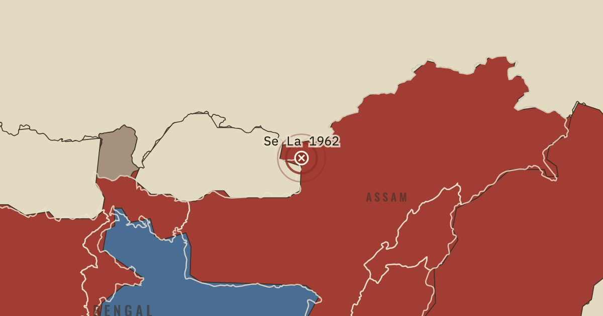
On the Indian independence map as “Se La and Bomdila”
20 Oct – 21 Nov 1962 — China’s army overran Indian posts below Thag La and captured Tawang. In November it broke the defense of Se La pass and Bomdila, reaching the edge of the Assam plain. China then declared a ceasefire and withdrew behind the McMahon Line, while retaining Aksai Chin.
When 20 Oct – 21 Nov 1962 Type Battle site Chapter India under Nehru (chapter 15 of Indian independence)Atlas Indian Independence & Partition, 1857–1964 Also in Mao’s China BATTLE SITE · INDIAN INDEPENDENCE & PARTITION, 1857–1964 These maps are reconstructed from published sources · Cliopatria v0.2.1: dated historical polity records · geoBoundaries India ADM2 (2021): named district reference geometry · Natural Earth v5.1.2: complete country reference geometry · Natural Earth: administrative reference units · Punjab Reorganisation Act, 1966 · Imperial Gazetteer of India (1908): Indian Empire political plate · States Reorganisation Act, 1956 · UNMOGIP: background to the Kashmir ceasefire line
Source details Cliopatria contributors / Seshat Global History Databank. CC BY 4.0 · Reviewed record selection; East/West Pakistan selected as complete components; source dates and identities retained. geoBoundaries / Pathways Data Pvt Ltd / lgdirectory.gov.in. ODbL 1.0 · Selected complete named districts dissolved as documented historical reporting-region proxies. Derived database also available in reconstructed-india.geojson under ODbL 1.0. Natural Earth. Public domain Natural Earth. Public domain · Full components retained and dissolved into explicitly dated historical groups; no source-coordinate simplification. Government of India; transfer to Himachal takes effect 1 November 1966. Historical factual reference; no source prose reproduced J. G. Bartholomew / Imperial Gazetteer of India, 1908; scan Fowler & Fowler. Public domain · Native-resolution colour-boundary extraction; printed graticule registration; printed label holes removed, territorial enclaves retained. 1908 geography is explicitly a nearby-date proxy in earlier chapters. Government of India; historical state-grouping reference. Historical factual reference; no source prose reproduced United Nations Military Observer Group in India and Pakistan. Historical factual reference; no source prose reproduced Partition and Kashmir lines use the closest downloadable successor boundary references. Later river and enclave changes, and the 1972 LoC adjustments, are not represented as exact 1947/1949 surveys.
Linguistic states are made from dissolved successor units, corrected for the pre-1966 Punjab/Himachal transfer. Some local district exchanges after the period remain source-vintage approximations.
proxy: Contemporary regional reference · proxy: Historical enclave, source-vintage outline · proxy: Modern line-of-control reference for the 1949 ceasefire line · proxy: Natural Earth v5.1.2 · proxy: Sikkim protectorate, contemporary same-unit outline · reconstruction: 1908 published Kashmir outline / contemporary Chinese administration reference · reconstruction: 1956 grouping; contemporary component geometry · reconstruction: 1956–1964 boundary grouping using successor district geometry · reconstruction: 1960 grouping; contemporary component geometry · reconstruction: 1963 grouping; contemporary component geometry · vector: 1890–2023 · vector: 1947–1975 · vector: 1948–1968 · vector: 1948–1986 · vector: 1953–1978 · vector: 1963–1972
Layer records and reconstruction methods
In the same chapter
Related
THE FREE PRINTABLE STUDY GUIDE
Get the printable study guide for Indian Independence & Partition free. I’ll send you a few short letters, then one when a new atlas opens. That’s all. — Paul
NO TRACKING · YOUR ADDRESS IS USED FOR THE DISPATCH AND NOTHING ELSE ·
UNSUBSCRIBE ANYTIME