MAPS OF HISTORY · INDIAN INDEPENDENCE · BATTLES AND EVENTS · Siege of CawnporeIndian independence · SITE OF MEMORY · 1857
Siege of Cawnpore (1857)
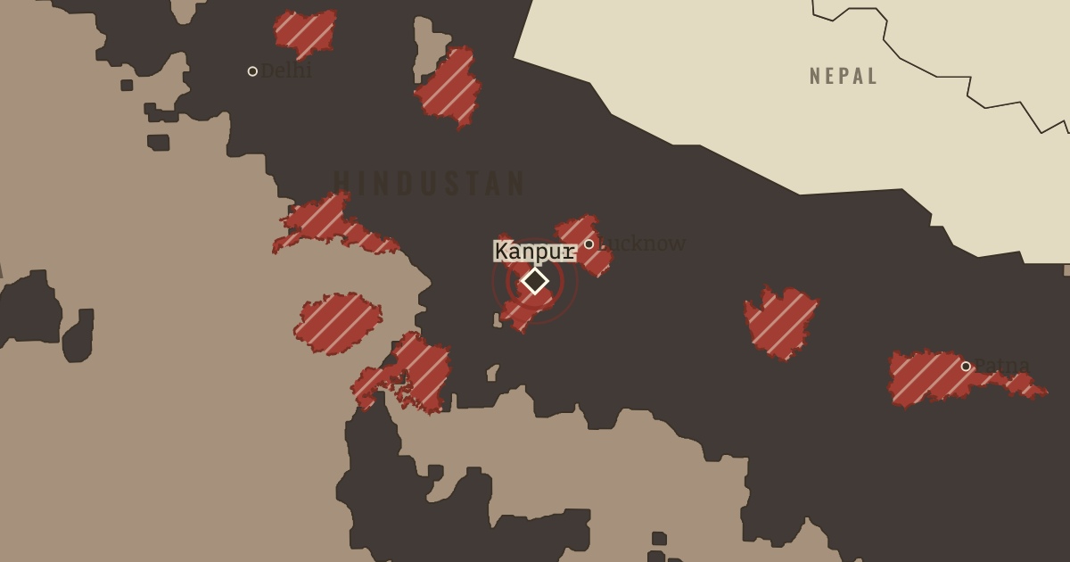
On the Indian independence map as “Kanpur — Satichaura Ghat and Bibighar”
27 Jun & 15 Jul 1857 — Nana Sahib promised the besieged British garrison safe passage, and it surrendered. At the river ghat, his men and rebel sepoys opened fire and killed most of the men. On 15 July, men acting for his court killed about 200 captive women and children at the Bibighar. Remember them.
When 27 Jun & 15 Jul 1857 Type Site of memory Chapter Indian Rebellion of 1857 (chapter 1 of Indian independence)Atlas Indian Independence & Partition, 1857–1964 SITE OF MEMORY · INDIAN INDEPENDENCE & PARTITION, 1857–1964 These maps are reconstructed from published sources · Cliopatria v0.2.1: dated historical polity records · geoBoundaries India ADM2 (2021): named district reference geometry · Natural Earth v5.1.2: complete country reference geometry · Natural Earth: administrative reference units · Imperial Gazetteer of India (1908): Indian Empire political plate · Cambridge Modern History Atlas (1912): principal centres of the 1857–1859 rebellion
Source details Cliopatria contributors / Seshat Global History Databank. CC BY 4.0 · Reviewed record selection; East/West Pakistan selected as complete components; source dates and identities retained. geoBoundaries / Pathways Data Pvt Ltd / lgdirectory.gov.in. ODbL 1.0 · Selected complete named districts dissolved as documented historical reporting-region proxies. Derived database also available in reconstructed-india.geojson under ODbL 1.0. Natural Earth. Public domain Natural Earth. Public domain · Full components retained and dissolved into explicitly dated historical groups; no source-coordinate simplification. J. G. Bartholomew / Imperial Gazetteer of India, 1908; scan Fowler & Fowler. Public domain · Native-resolution colour-boundary extraction; printed graticule registration; printed label holes removed, territorial enclaves retained. 1908 geography is explicitly a nearby-date proxy in earlier chapters. Cambridge University Press / Stanford’s Geographical Establishment; 1912. Public domain · Named underlined centres are represented by surrounding modern districts. No continuous rebel-held territory is asserted. Princely-state geography follows the published 1908 plate. Earlier chapters use it explicitly as a nearby-date reference, rather than reconstructing local state transfers as exact dated surveys.
The British administrative backdrop uses the complete 1859 Raj source, the closest reference before or after the rebellion. The 1857–1858 source excludes insurgent-controlled northern India; those gaps must not appear as neutral territory beneath the thematic rebellion locators.
The treaty/paramountcy patchwork provides a political reference. Hatches for famine, violence and rebellion locate affected reporting regions rather than areas of uniform territorial possession.
The original lesson describes a brief rebel-held territorial tide. The new map shows the source-attested rebellion centres and surrounding districts instead, and excludes these thematic locators from the sovereignty-area tally.
proxy: 1859–1859 · proxy: Contemporary regional reference · proxy: Historical enclave, source-vintage outline · proxy: Modern same-enclave reference · proxy: Natural Earth v5.1.2 · reconstruction: 1852–1885 grouping; modern regional reference · reconstruction: 1857–1859 centres, 2021 surrounding district outlines · reconstruction: 1908 printed patchwork with coastal registration · vector: 1842–1889 · vector: 1853–1858 · vector: 1856–1889 · vector: 1857–1858 · vector: 1857–1872
Layer records and reconstruction methods
In the same chapter
Related
THE FREE PRINTABLE STUDY GUIDE
Get the printable study guide for Indian Independence & Partition free. I’ll send you a few short letters, then one when a new atlas opens. That’s all. — Paul
NO TRACKING · YOUR ADDRESS IS USED FOR THE DISPATCH AND NOTHING ELSE ·
UNSUBSCRIBE ANYTIME