MAPS OF HISTORY · WWI · MAPS BY YEAR · August 1920The Great War, 1871–1923 · THE MAP IN AUG 1920
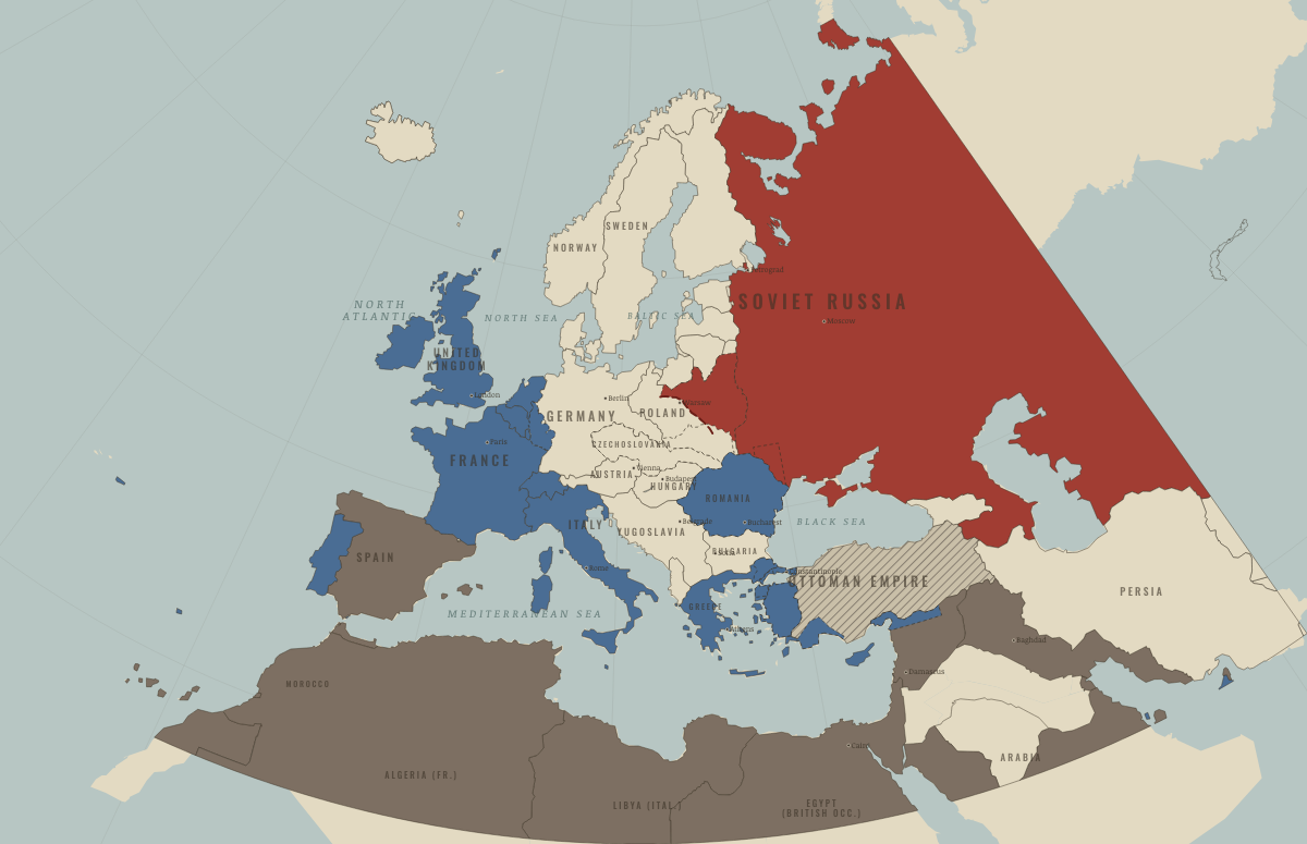
Map of Europe in August 1920
Warsaw and Sèvres · after WWI
Europe in August 1920: Warsaw and Sèvres. Since June 1919, 5 territories changed status on this map: including German Empire, East Prussia (German Empire), Austria-Hungary and 2 more.
AUG 1920 · THE GREAT WAR, 1871–1923 These maps are reconstructed from published sources · British Library: Curzon papers, Italian forces in Asia Minor, 1919 · UK Parliament: Asia Minor, 10 July 1919 · Cliopatria v 0.2.1 · Natural Earth physical geography · Maps of History: Great War geographic decisions · US Army: American Forces in Germany · Treaty of Peace with Turkey, Sèvres, 10 August 1920 · Treaty of Versailles: Rhineland occupation · Polish educational platform: Battle of Warsaw, 1920
Source details British Library via Qatar Digital Library; Adalia, Budjak, Buldur, Makri, Marmarice, Budrum, Sokia and Scalanova detachments.. Historical factual location citation; no scan redistributed Hansard; Italian Adalia garrison and southwestern coastal detachments.. Historical geographic evidence citation Cliopatria contributors / Seshat Global History Databank. Source polygons retained with original identities; geographic selections and corrections by Maps of History.. CC BY 4.0 Made with Natural Earth; geographic reference and physical land only. No modern political boundary is used as a historical boundary.. Public domain Maps of History. Campaign-sector connectors and contextual regions are identified separately from imported vector outlines.. Original geographic reconstruction using attributed historical evidence US Army Medical Department history; Moselle Valley from Luxembourg to Rhine, Trier and Koblenz. Boundary derived from treaty river and bridgehead provisions rather than an absent annual control polygon.. US government historical geographic evidence UK Treaty Series 11/1920. The signed treaty never entered into force; proposal outlines remain distinct from actual occupation.. Historical treaty facts; no artwork redistributed Versailles articles 428–432; Rhineland occupation and bridgeheads.. Historical treaty facts; original geographic reconstruction Polish Ministry educational platform: Wkra, Radzymin, Wieprz and the Warsaw campaign.. Historical geographic facts, independently reconstructed; artwork not copied Annual source features can describe claims, legal territory or military control. Occupied extensions are separated from the prewar Central Power homelands, while the original source names and shapes remain available.
reconstruction: 1919–1921 Italian Adalia occupation region · reconstruction: 1919–1923 · reconstruction: 1920 · reconstruction: 1920.62 · reconstruction: 1920–1921 · reconstruction: 1920–1921 source control · reconstruction: 1920–1923 · reconstruction: 1920–1935 · reconstruction: 1922–1923 · reconstruction: MidAugust 1920 · reconstruction: MidAugust 1920 geographic campaign reference · vector: 1815–1937 · vector: 1848–1935 · vector: 1864–1921 · vector: 1905–1921 · vector: 1908–1935 · vector: 1912–1921 · vector: 1912–1955 · vector: 1917–1921 · vector: 1918–1926 · vector: 1918–1938 · vector: 1919–1921 · vector: 1919–1923 · vector: 1919–1937 · vector: 1920–1921 · vector: 1920–1923 · vector: 1920–1931 · vector: 1920–1935 · vector: 1920–1937 · vector: 1920–1939
Layer records and reconstruction methods
What changes on the map
On the ground The Red Army held this area at its furthest advance in mid-August 1920. East of the Dniester, this was Soviet territory between the wars. The Treaty of Sèvres (1920) partitioned the area into Greek, Allied, Italian and French zones of occupation (blue), surrounding the Anatolia held by the Ankara nationalists. Sèvres assigned Eastern Thrace to Greece in 1920; it returned to Turkey in 1922–23. Allied forces occupied Constantinople and the Bosphorus in 1918–23. The shores of the Dardanelles formed an Allied-controlled zone of the Straits. Italy occupied the Antalya region in 1919–21. France occupied Cilicia in 1919–21. Related maps
◧ EMBED THIS MAP ON YOUR SITE
You may embed this map free if you keep the attribution link. Teachers can find print-ready
study guides at /study/ .
THE FREE PRINTABLE STUDY GUIDE
Get the printable study guide for WWI free. I’ll send you a few short letters, then one when a new atlas opens. That’s all. — Paul
NO TRACKING · YOUR ADDRESS IS USED FOR THE DISPATCH AND NOTHING ELSE ·
UNSUBSCRIBE ANYTIME