Norse and Aztecs · CHAPTER 10 ·
Layout of Tenochtitlan
Chapter 10 of Climate and Innovation: The Norse and the Aztecs, c. 790–1521: “The Planned City”
Tenochtitlan was a planned city on water: four quarters around a walled sacred precinct dominated by the Templo Mayor, a rough grid of streets and canals, and three causeways with removable bridges linking it to the shore. Drinking water came by aqueduct from Chapultepec, and human waste was collected by canoe for fertiliser.
Chapter 10 is included with every paid plan. WW2 is free in full, and chapter 1 of every atlas is free. A free account opens 3 more chapters a day. Starter, at $9 a month, opens all 21 with no daily limit — see the plans.
Free printable Norse and Aztecs study guide, sent by email ↓
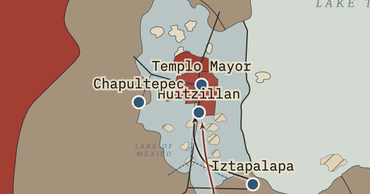
The map above is the world of The Basin of Mexico, November 1519 — The city the Spaniards saw.
Part of IB History: The Norse and the Aztecs →
SHORT EXPLANATION
A large city in the middle of a shallow lake needed ways to move people and goods, bring in drinking water and deal with waste. Tenochtitlan’s builders laid out streets and canals in a rough grid around four quarters and a walled sacred precinct. As in Venice, a resident could travel on foot or by canoe. Three causeways, raised roads across the water, connected the island to shore; removable wooden bridges let water flow through and could also block an enemy. The map marks the quarters with dotted lines and the causeways and dike with dark lines. An aqueduct brought water from Chapultepec. Canoes collected human waste for tanning and fertilizer, putting to use material many medieval towns dumped.
The Spaniards who arrived in November 1519 reached for familiar comparisons. Bernal Díaz del Castillo thought the buildings rising from the water resembled the enchantments of a chivalric romance; Hernán Cortés compared the market squares with the greatest in Spain. On 8 November Moctezuma II, ruler of the Mexica, often called the Aztecs, met Cortés on the southern causeway, along the arrow on the map. He lodged the Spaniards in a palace beside the sacred precinct. The capital they entered had grown from a marsh through ninety years of investment in dikes, aqueducts and chinampas, the raised fields in the lake.
The full story
At the heart of Tenochtitlan stood a sacred precinct roughly 430–460 metres across. Bernardino de Sahagún’s informants listed 78 structures within it. The largest was the Templo Mayor, a pyramid with shrines to Huitzilopochtli, god of war and the sun, and Tlaloc, god of rain. Rulers enlarged it repeatedly: excavations led by Eduardo Matos Moctezuma since 1978 have identified seven major building stages. The city around this religious center was divided into four quarters, Moyotlan, Teopan, Atzacoalco and Cuepopan, with causeways leading north, west and south. Within the quarters were about seventy calpolli. These neighborhoods, each with temples, schools and officials, gave the capital manageable units of local government, much like boroughs.
The plan had to make the lake useful while controlling its dangers. Canals beside many streets carried canoes to house doors and helped drain rainwater. The causeways shown radiating from the island had gaps for the flow of lake water, crossed by wooden bridges that could be removed in defense. Drinking water came by a different route. The dashed blue line on the map traces the aqueduct from Chapultepec in the west; its water followed the Tlacopan causeway to the precinct, and canoes carried it for sale in other districts. Díaz described reed latrines beside roads and waste sold from canoes for tanning. Much waste also fertilized the chinampas. Keeping wastewater apart from drinking water helped make the city healthier than many contemporary European towns.
On 8 November 1519, Moctezuma met Cortés at Huitzillan, near the southern entrance. The dark arrow follows the Spaniards’ route into the capital. Their descriptions give us an account of the city, but their purposes matter. In his second letter to Charles V, sent in 1520, Cortés described a city on a salt lake, its causeways, a two-channel aqueduct and a market where he estimated more than 60,000 people traded daily. Díaz, writing decades later, recalled soldiers wondering whether the sight was a dream. Both wanted to impress Spanish readers. Read with that purpose in mind and alongside archaeological evidence, their accounts reveal an exceptionally large and organized city.
FULL EXPLANATION
Cortés and Díaz as witnesses
Cortés and Díaz saw the same lake cities, but they had different reasons for writing about them. Cortés sent his second letter to Charles V in October 1520, after being expelled from Tenochtitlan. He had launched his expedition without royal authority, and its wealth and order helped make the case for the land he claimed. Comparisons with Salamanca and Seville made the city intelligible to the king. Díaz wrote his True History in old age, decades later, partly to correct Cortés’s chaplain Francisco López de Gómara and win credit for ordinary soldiers. His recollection of buildings like the enchantments in the romance of Amadís drew on a literary convention as well as his memory. Both describe causeways, aqueducts, markets and canoes, and archaeology supports these features. Their agreement is useful evidence, though they traveled in the same expedition and cannot simply be treated as independent witnesses.
The Templo Mayor rediscovered
The chronicles described a great religious center; excavation has made it possible to measure and examine one. After electricity workers made a chance discovery in 1978, Eduardo Matos Moctezuma began the Templo Mayor Project, which has excavated the site ever since. Seven superimposed stages, each larger than the last, correspond to accounts of successive rulers enlarging the temple. Offerings buried in its platforms included marine shells, jaguar remains and greenstone. Materials from coasts and forests hundreds of kilometres away show the reach of tribute and trade, although an individual object does not reveal its exact route. Another discovery has changed assumptions about sacrifice. Since 2015 Raúl Barrera’s Urban Archaeology Program has uncovered the Huei Tzompantli, the great skull rack. By 2023 it had identified 655 skulls, including those of women and children, challenging the older assumption that only captured warriors were sacrificed there.
Planned from above or grown from below?
The regular city invites a question: who made the plan? Streets and canals met at right angles, and the sacred precinct aligned with the causeways. The Codex Mendoza’s founding page shows four quarters at the city’s birth. Edward Calnek’s study of colonial property records also found long, narrow house lots in regular rows, each facing a street and a canal. Such evidence points to surveying and deliberate design. It does not tell us who decided every feature of a residential district. The roughly seventy calpolli were older communities of kin and craft groups, with their own temples and leaders, and households built chinampas at the island’s edges as the city expanded. Michael Smith argues that Mesoamerican capitals combined planned ceremonial cores with more organic residential districts. Tenochtitlan fits that pattern: rulers established a framework, and neighborhoods helped fill it.
Key places on the map
On this day
Why it happened
Life on water demanded planning. On an island in a shallow lake, adding a house meant first making ground for it. Builders raised lots from the lake bed and connected them to canals, which provided transport and drainage. Chinampas spread outward in regular rows, while streets and waterways served the growing settlement. The setting encouraged order, even though the extent of central direction in residential districts remains disputed.
Hydraulic works made a large city possible. Growth depended on waterworks that addressed two different needs. A dike built around 1449 protected the island from flooding and helped freshen the lagoon. By 1466 an aqueduct brought drinking water from Chapultepec to a city without springs of its own. These mid-fifteenth-century works supported expansion far beyond the early settlement, to perhaps 200,000 inhabitants by 1519.
Tribute paid for monumental building. The monumental capital drew on resources far beyond its center. Temples, palaces and causeways needed stone, timber, lime and labor from the basin and beyond; tribute supplied materials and helped feed the workers. Successive rulers enlarged the Templo Mayor as a display of power. Its masonry made part of the empire’s wealth visible in the middle of the lake.
Religion organised space. The city’s center also had a place in Mexica religion. The Templo Mayor stood at the center of the cosmos, where earth met the heavens and the underworld, with shrines to Huitzilopochtli and Tlaloc. The four quarters reflected the four directions of the universe. This sacred order gave rulers legitimacy and residents a place within it. Religious and practical purposes shared the city’s spaces, though that does not establish a single sacred plan for every residential street.
THE TURNING POINT
Huitzillan, 8 November 1519. When Moctezuma II met Hernán Cortés at Huitzillan on 8 November 1519, the visitors encountered the result of ninety years of Mexica engineering. Their later accounts provide major written evidence of the capital, although each must be read with its audience in mind. The meeting also preceded a transformation of the setting itself: within twenty months the causeways, canals and aqueduct would be part of a battlefield, and the city would be destroyed.
What it changed
A city the Spaniards would rebuild on. The conquerors built Mexico City over the ruins, but much of the earlier arrangement shaped what followed. Main causeways became streets; the cathedral and viceregal palace occupied the sites of the sacred precinct and Moctezuma’s palace. Elements of the grid remain in the historic center even though the lake has since been drained. Chapter 12 follows that later history.
The causeways become battle lines. The same causeways that brought travelers to the island concentrated armies on narrow routes. In the Spanish retreat of June 1520 and the siege of 1521, bridges and gaps designed to allow water through became deadly obstacles. Chapter 11 traces the fighting across the city’s connections to shore.
A model for later comparison. Modern discussions of sustainable cities often look to Tenochtitlan’s canals, aqueducts and reuse of waste. The comparison is striking: Europeans encountered an engineered urban system already more than a century old. Its construction and order also depended on tribute and forced labor, so the political system that supported the works belongs in the comparison.
DISCUSSION QUESTION — Was Tenochtitlan’s plan primarily a solution to environmental problems or an expression of political and religious power?
The plan served both purposes, often through the same works. Canals and streets allowed movement and drainage; the bridges, aqueduct and reuse of waste helped a dense population live on water. At the center, the sacred precinct and repeated enlargements of the Templo Mayor expressed religious and political authority, while the quarters and causeways related the city to the four directions. The connections ran deeper: rulers mobilized labor for hydraulic works, and a shrine to Tlaloc placed the rain god at the religious center. Historians still debate how much of the residential layout rulers directed and how much developed through neighborhoods. Tenochtitlan shows how environmental works can be built and maintained within political and religious institutions.
An interesting fact
In the early hours of 21 February 1978, electricity workers digging behind Mexico City’s cathedral struck a carved stone at a street corner. It was a disc of pink andesite about 3 metres across and roughly 8 tonnes in weight, depicting the dismembered moon goddess Coyolxauhqui. The discovery led the government to demolish a block of colonial-era buildings. Archaeologists led by Eduardo Matos Moctezuma could then excavate the Templo Mayor beneath; the site now lies open beside the cathedral.
Related
THE FREE PRINTABLE STUDY GUIDE
Get the printable study guide for Climate and Innovation free. I’ll send you a few short letters, then one when a new atlas opens. That’s all. — Paul
NO TRACKING · YOUR ADDRESS IS USED FOR THE DISPATCH AND NOTHING ELSE · UNSUBSCRIBE ANYTIME