Norse and Aztecs · CHAPTER 9 ·
Aztec chinampas
Chapter 9 of Climate and Innovation: The Norse and the Aztecs, c. 790–1521: “Chinampas: Feeding a City”
Chinampas were raised fields built in the shallow fresh lakes of Xochimilco and Chalco from mud and plants anchored by willows, where water softened frost. With a market and imperial tribute, they helped feed Tenochtitlan’s perhaps 200,000 people after the Triple Alliance took Xochimilco around 1430 and Chalco by about 1465.
Chapter 9 is included with every paid plan. WW2 is free in full, and chapter 1 of every atlas is free. A free account opens 3 more chapters a day. Starter, at $9 a month, opens all 21 with no daily limit — see the plans.
Free printable Norse and Aztecs study guide, sent by email ↓
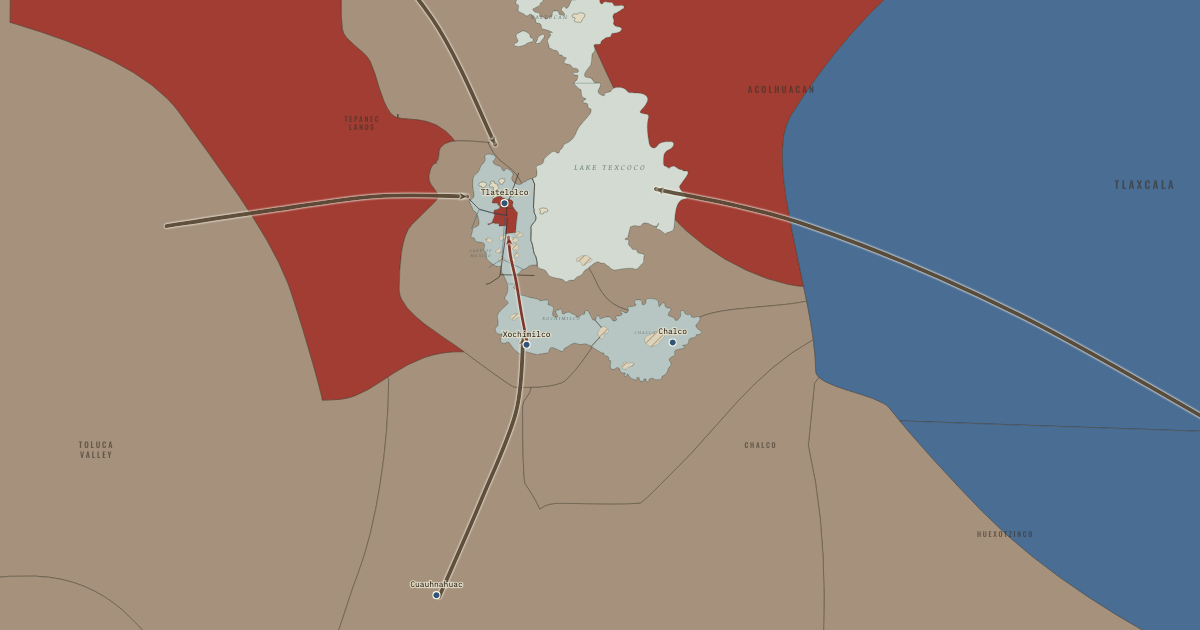
The map above is the world of The Basin of Mexico, 1515 — The empire at its height under Moctezuma II.
Part of IB History: The Norse and the Aztecs →
SHORT EXPLANATION
Tenochtitlan stood on an island 2,240 metres above sea level, yet by 1519 it may have housed 200,000 people. Feeding them required more than the island could grow. Around the southern lakes, farmers made chinampas: raised beds of mud and plants on reed frames, secured with willows and separated by canals. Water kept the soil moist and softened frosts, while mud from the canals renewed the beds. The pale fields on the map show the districts at Xochimilco and Chalco. Like a hydroponic greenhouse made from the lake itself, this system used water to meet the basin’s climatic hazards.
The capital also drew food through exchange and imperial obligations. Canoes brought produce to Tlatelolco, a market that Hernán Cortés estimated drew more than 60,000 people daily. Buyers used cacao beans and cotton cloaks as money. The Codex Mendoza, a painted record made for the Spanish viceroy, lists the goods owed by 38 provinces, including bins of maize, beans and amaranth, as well as cloth, cacao and feathers. Tribute arrows enter the basin from every edge of the map. The city had several sources of supply, but its great size depended on keeping those connections open.
The full story
Farmers had refined the chinampa long before the Mexica gained control of the southern lakes. They dug canals through shallow water and piled mud and plants into long rectangular beds. Stakes held the beds in place, as did ahuejote willows, whose roots bound their edges. Seedlings started in nurseries of mud cut into small blocks; once transplanted, they left room for further crops. This careful use of space and water paid off. Studies summarized by José Luis de Rojas and Juan José Batalla put maize yields at about 3,000 kilograms per hectare, compared with 1,000–1,400 on ordinary fields. The surrounding water also moderated temperatures, giving crops some protection from the frosts that threatened rain-fed maize.
Control of the freshwater lakes brought this farming system into the orbit of the growing capital. The alliance conquered Xochimilco around 1430 and Chalco by about 1465. Many historians think that the state subsequently organized a substantial expansion of the fields. Pedro Armillas’s 1971 mapping from aerial photographs revealed a southern chinampa zone much larger than previously thought; estimates commonly put it at 9,000–12,000 hectares. Building it took labor on a remarkable scale. Lee Arco and Elliot Abrams estimate 25 million person-days over forty years, a person-day being one person’s work for one day. Local communities could have done the work, perhaps under state direction. Jeffrey Parsons estimated that the fields could feed 100,000 people or more—a large contribution, though not enough for the entire capital.
Other supplies reached the city through the market and tribute. At Tlatelolco, Bernal Díaz recalled, soldiers familiar with Rome and Constantinople said they had never seen a market so large, orderly and crowded. Cacao beans paid for small purchases, and cotton cloaks called quachtli paid for larger ones; a cloak was worth about 65–100 beans. The Codex Mendoza records provincial obligations like a tax register and depicts 42 great grain bins, although historians dispute their capacity and how often they were filled. The number of people to be fed is uncertain too: estimates range from under 100,000 to over 300,000. Michael Smith’s estimate of 212,500 on 13.5 square kilometres lies within the common range. Whatever the exact shares, the island city relied on food grown beyond its own ground.
FULL EXPLANATION
How productive were the chinampas?
The best case for chinampas does not require the popular claim that they produced seven harvests a year. Specialists reject that claim for maize, which yielded one or two crops. Vegetables and flowers could produce several, helped by raising seedlings in nurseries and transplanting them. Bernard Ortiz de Montellano’s estimate, cited by Rojas and Batalla, puts maize output at about 3,000 kilograms per hectare, against 1,000–1,400 on rain-fed land. How much land produced at that rate is harder to say. Armillas mapped the zone without publishing a single precise total, and estimates of 9,000–12,000 hectares are repeated more often than demonstrated. Parsons calculated that the fields could feed perhaps 100,000 people or more. Their value was not simply a high yield: steady moisture and protection from frost made harvests more dependable where drought and cold threatened ordinary fields.
Counting the tribute in the Codex Mendoza
The Codex Mendoza seems to offer a way to count the empire’s tribute. Its pages show the towns and goods owed by each of 38 provinces, with numbers attached to painted symbols and explanations in Spanish. But reading the numbers requires decisions that change the totals greatly. Rojas and Batalla note disagreements over whether a glyph represents one item or a load of twenty, and whether goods were paid once, twice or four times yearly. The highest interpretation gives several million pieces of cloth a year; the lowest gives about a twentieth as many. The 42 grain bins raise a further question. Each may have held hundreds of tonnes, yet Pedro Armillas doubted the grain went to the capital and suggested that it remained in provincial reserves. The record shows extensive, organized obligations, while their volume and destination remain uncertain. Popular totals of thousands of tonnes of maize and millions of cloaks have no traceable scholarly source.
Why estimates of Tenochtitlan’s population differ
To calculate the city’s food needs, we first need its population. The estimates differ by a factor of three or more because historians must make different assumptions about the evidence. Conquerors reported round numbers such as 60,000 houses, a count that might mean buildings, households or the wider basin. William Sanders, Jeffrey Parsons and Robert Santley combined a city area of 12–15 square kilometres with densities from colonial records and estimated 150,000–200,000 people. Edward Calnek reconstructed house lots from early colonial documents and reached higher, explicitly tentative figures. Michael Smith’s 2005 comparison with other Mesoamerican cities gave 212,500 on 13.5 square kilometres. Lower estimates of 60,000–100,000 assume smaller households or less built-up land. Each figure changes what the fields, market and tribute had to supply. Even at the lower end, the island could not have fed its inhabitants from its own land.
Key places on the map
Why it happened
Frost and unreliable rain threatened ordinary fields. The basin’s altitude exposed maize to two dangers. Above 2,200 metres, a September frost could arrive early, while summer rains could fail, as they did in 1452–54. Chinampa beds had moisture rising from below, and the water around them moderated the cold. Their location in the shallow lakes thus answered both problems, much as irrigation helps farmers through a dry season, although it could not prevent every crop failure.
The dike freshened water for new fields. Fresh water was indispensable: salt kills crops. Chinampas therefore flourished in the spring-fed southern lakes. Around 1449 Nezahualcoyotl’s dike helped separate the western lagoon from salty Lake Texcoco, making more water around Tenochtitlan suitable for cultivation. By 1469 the map shows fields south of the city. A work built for flood control also helped create conditions for the later fifteenth-century expansion of farming.
Conquest gave the state control of the best water. The freshwater farming zones belonged to communities the alliance first had to defeat. It took Xochimilco and neighboring lake towns around 1430 and the Chalco confederation by about 1465, after decades of war. The victories gave the capital access to both fields and the labor of their communities. Arco and Abrams estimate 25 million person-days over forty years for the southern fields; local communities could have supplied that work, perhaps under state direction. How far the state directed it remains debated.
A growing city needed food on a scale no island could supply. A few thousand people lived in Tenochtitlan in the 1300s. By 1519 the number may have reached 150,000–200,000 or more on an island of about 13.5 square kilometres. Growing food intensively in the lake helped, but the city still needed supplies from elsewhere. Canoes carried nearby produce, markets gathered goods from many communities, and tribute reached beyond the basin. The search for supplies accompanied expansion toward the warm, wet Gulf coast.
THE TURNING POINT
The conquest of Xochimilco, c. 1430. Xochimilco’s conquest soon after 1428 joined an old agricultural skill to a new center of power. Local communities had built chinampas for generations; the alliance now controlled some of the basin’s most productive farmland and could draw on its labor and tribute. Historians think state organization may also have helped enlarge the fields. For a capital with a growing need for food, that control mattered.
What it changed
One of the world’s largest cities. The scale of the city astonished Spaniards who arrived in November 1519. Tenochtitlan and Tlatelolco together probably housed 150,000–200,000 people or more, exceeding any city in Spain. Food made such a concentration possible. Chapter 10 considers the other demands of island life: organizing water, streets, canals and waste for its inhabitants.
A food supply tied to empire. Food from distant communities helped sustain the capital, but those connections could also be broken. Provinces might rebel against tribute, and enemies could cut routes. In 1521 former subjects joined the Spaniards and blockaded the lake, turning the city’s dependence into a vulnerability during the siege described in Chapter 11.
A technique that outlived the empire. Chinampa farming survived the conquest of the empire. Fields at Xochimilco still supply vegetables and flowers in parts of southern Mexico City and form part of a UNESCO World Heritage site. Chapter 12 follows this longer history: the technique continued after the state that expanded it had fallen.
DISCUSSION QUESTION — How far did the chinampas, as opposed to tribute and trade, make Tenochtitlan possible?
The chinampas gave the city a substantial supply close enough for fresh produce to travel by canoe. Their moisture and frost protection made harvests more reliable, and estimated maize yields were perhaps three times those of rain-fed fields. The southern zone expanded after Xochimilco and Chalco were conquered. Parsons estimated that chinampas could feed perhaps 100,000 people or more, but many estimates put the city’s population at 150,000–200,000 or higher. The difference had to be made up through exchange and tribute, including grain, beans and cotton from distant provinces. We cannot calculate exact shares while the cultivated area, population and tribute volumes remain uncertain. The city depended on several connected sources, and disruption to those connections threatened its food supply.
An interesting fact
Cacao beans were small change in basin markets, and they attracted counterfeiters. The sixteenth-century Florentine Codex, compiled under the friar Bernardino de Sahagún, describes sellers who emptied beans and filled the shells with earth or other material so they would pass as good cacao. The deception worked on the same principle as a counterfeit coin: the appearance of something valuable concealed a substitute.
Related
THE FREE PRINTABLE STUDY GUIDE
Get the printable study guide for Climate and Innovation free. I’ll send you a few short letters, then one when a new atlas opens. That’s all. — Paul
NO TRACKING · YOUR ADDRESS IS USED FOR THE DISPATCH AND NOTHING ELSE · UNSUBSCRIBE ANYTIME