MAPS OF HISTORY · COUNTRIES · Somalia7 ATLASES
History of Somalia in maps
Somalia as it appears in 7 interactive history atlases, from 1890 to 2015: Somalia, Italian Somaliland / Somalia, Italian Somaliland. Each era below lists who ruled the land and when control changed, linked to the dated map that shows it.
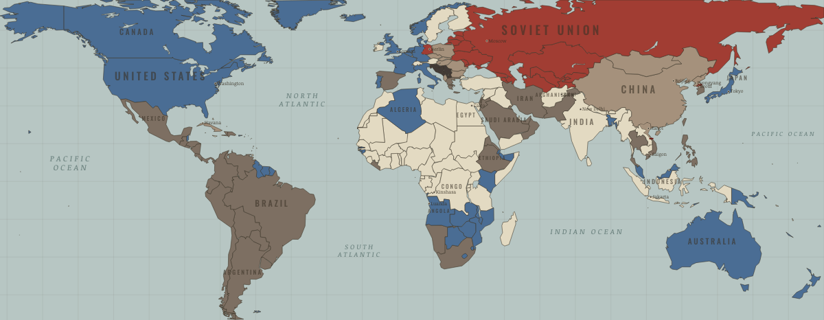
MAP OF THE WORLD IN OCTOBER 1962 These maps are reconstructed from published sources · The Berlin Airlift, 1948–1949 · North Atlantic Treaty: Algerian departments cease to apply from 3 July 1962 · Berlin’s four-power status and its termination · The rise and fall of the Berlin Wall · Cliopatria v0.2.1 historical polities · Decolonization of Asia and Africa, 1945–1960 · United Nations Command: the 1953 armistice · NATO membership chronology · Natural Earth v5.1.2 country geography · Natural Earth administrative references · The collapse of the Soviet Union · 1954 Geneva agreement, Annex I: demarcation line · South Yemen: independence and alignment chronology · South Yemen: Soviet relationship, 1971 intelligence estimate
Source details US government historical publication. Historical facts cited; no source artwork or prose reproduced NATO, treaty footnote 2. Historical treaty facts cited; no artwork or prose reproduced US government historical publication. Historical facts cited; no source artwork or prose reproduced US government historical publication. Historical facts cited; no source artwork or prose reproduced Cliopatria contributors / Seshat Global History Databank. CC BY 4.0 · Selected dated records; documented component selection, unions and shared-edge extraction. US Department of State, Office of the Historian. US government publication United Nations Command. Historical facts cited; no source artwork or prose reproduced NATO. Historical facts cited; no artwork or prose reproduced Natural Earth contributors. Public domain · Full source components and holes retained; documented historical unions and repairs. Natural Earth contributors. Public domain US Department of State, Office of the Historian. US government publication US Department of State, FRUS 1952–1954, Volume XVI, document 1035. US government publication of diplomatic documents US Department of State. US government historical publication US Department of State, FRUS 1969–1976, volume XXIV, document 182. US government historical publication This political-alignment geography uses national and administrative extents; it does not map every military front. Modern-reference perimeters are explicitly recorded where no more suitable reviewed historical geometry was adopted. All source parts and holes are retained.
The Soviet, Yugoslav, Czechoslovak, Sudanese and other historical unions remove later internal borders. Occupation and armistice lines retain their separate meanings.
South Yemen uses the 1969 source as a geographic proxy for earlier Aden/protectorates. The boundaries and status of individual protectorates are not resolved at this scale.
Dated assignments correct omissions across the legacy views: independent Algeria is non-aligned after July 1962; Greece and Turkey join NATO in 1952, and Spain in 1982. South Yemen is separate from North Yemen, with British administration before late 1967 and the Soviet-aligned Marxist government after 1969.
proxy: 1945–1990, later municipal exterior reference · proxy: Natural Earth v5.1.2 contemporary reference · proxy: Pre-1963 Netherlands New Guinea; later provincial reference · reconstruction: 1945–1991 · reconstruction: 1945–1991 geographic union · reconstruction: 1952–1991 · reconstruction: 1953 · reconstruction: 1953–1963 · reconstruction: 1953–1972 · reconstruction: 1954 (1956 vector proxy) · reconstruction: 1958–1989 · reconstruction: 1960–1991 · reconstruction: Before May 1963 · reconstruction: Postwar Yugoslav reference · reconstruction: Pre-1963 North Borneo; later coast/reference exterior · vector: 1936–1986 · vector: 1946–1946 · vector: 1948–1962 · vector: 1949–1952 · vector: 1953–2023 · vector: 1956–1966 · vector: 1958–1959 · vector: 1958–1960 · vector: 1958–1968 · vector: 1961–1962 · vector: 1969–1986
Layer records and reconstruction methods
What was Somalia before it was Somalia? The sections below follow this
land through every era covered by the Maps of History atlases: who ruled it, what it was
called, and when control changed. Each line links to the dated map. Modern borders serve
as an approximation, as each atlas says on the map itself.
Somalia · Industrial Revolution
1890 Colony or dependency — the opening position 1890 Colony or dependency
INDUSTRIAL REVOLUTION: EVERY CHAPTER AND MAP →
Italian Somaliland / Somalia · Haiti and Kenya independence
On 1 July 1960 Italian Somaliland in the south and British Somaliland in the north united as the Somali Republic. Its five-pointed star stood for all territories where Somalis lived, including Kenya’s north-east. Britain left those districts inside Kenya in 1963. Somalia then backed insurgents in the Shifta War until the Arusha Memorandum of 1967.
1890 Other states and societies — the opening position 1895 Under colonial rule JAN 1960 Other states and societies
HAITI AND KENYA INDEPENDENCE: EVERY CHAPTER AND MAP →
Somalia · WWI
NOV 1914 Entente-aligned & imperial territories — the opening position
WWI: EVERY CHAPTER AND MAP →
Italian Somaliland (mod. Somalia) · Road to WW2
JAN 1933 The aggressors (Japan, Germany, Italy) — the opening position
ROAD TO WW2: EVERY CHAPTER AND MAP →
Somalia · Cold War
COLD WAR: EVERY CHAPTER AND MAP →
Somalia · Decolonization of Africa
In 1960 Italian Somaliland and British Somaliland united at independence to form Somalia. This rare single ethnic nation sought to bring together Somalis whom colonial borders had placed across Ethiopia, Kenya and Djibouti. That irredentist ambition drove the 1977 Ogaden war. Somalia lost and the frozen-border principle held; its later state collapse made it a tragic counter-case to the OAU’s border bargain.
1945 Portuguese, Belgian, Spanish & Italian-ruled — the opening position 1960 Independent Africa
DECOLONIZATION OF AFRICA: EVERY CHAPTER AND MAP →
Somalia · Feminism and the Tunisian Revolution
1945 Authoritarian, one-party or colonial rule — the opening position NOV 1961 Right won in law MAY 1970 No reform yet / outside this story
FEMINISM AND THE TUNISIAN REVOLUTION: EVERY CHAPTER AND MAP →
Related
THE FREE PRINTABLE STUDY GUIDE
Get a printable atlas study guide of your choice free. I’ll send you a few short letters, then one when a new atlas opens. That’s all. — Paul
NO TRACKING · YOUR ADDRESS IS USED FOR THE DISPATCH AND NOTHING ELSE ·
UNSUBSCRIBE ANYTIME