MAPS OF HISTORY · STALIN’S SOVIET UNION · BATTLES AND EVENTS · Soviet invasion of HungaryStalin’s Soviet Union · TURNING POINT · 1956
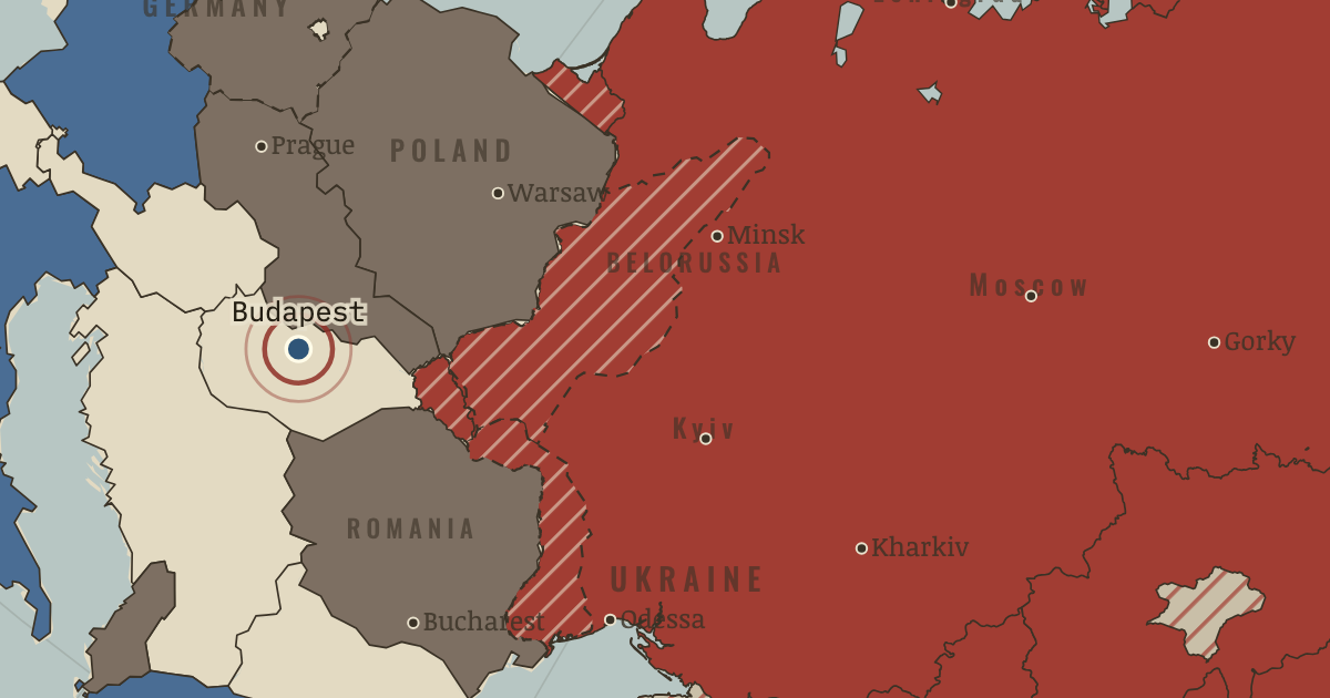
Soviet invasion of Hungary (1956)
On the Stalin’s Soviet Union map as “Budapest, 1956”
4 Nov 1956 — Soviet tanks crushed the Hungarian revolution, which the Secret Speech eight months earlier had helped to inspire. About 2,500 Hungarians and 700 Soviet soldiers died. De-Stalinisation stopped at the bloc’s borders.
When 4 Nov 1956 Type Turning point Chapter Death of Stalin and de-Stalinisation (chapter 12 of Stalin’s Soviet Union)Atlas The Soviet Union under Stalin, 1924–1953 Also in WW2 · Cold War · Refugee crises TURNING POINT · THE SOVIET UNION UNDER STALIN, 1924–1953 These maps are reconstructed from published sources · Cliopatria v0.2.1 historical political boundaries · Natural Earth v5.1.2 country geography · Natural Earth full administrative reference geometry · Published projection for the Soviet Union location-map family · Bukharan PSR in the Soviet Union (1922), published vector locator · Volga German ASSR, 20 July 1930: published locator map · The Berlin Airlift, 1948–1949 · Berlin’s four-power status and its termination · The rise and fall of the Berlin Wall · Cliopatria v0.2.1 historical polities · Decolonization of Asia and Africa, 1945–1960 · Natural Earth v5.1.2 country geography · Natural Earth administrative references · Cliopatria v0.2.1 — dated political boundaries · Natural Earth — physical reference geography · Natural Earth 10m — provincial study-region reference · Natural Earth 10m island components; FRUS 1955 evacuation chronology · Cliopatria v 0.2.1 — dated political boundaries
Source details Cliopatria contributors / Seshat Global History Databank. CC BY 4.0 · Dated source selection, component unions, disjoint display masks and source-relative border differences. Natural Earth contributors. Public domain Natural Earth contributors. Public domain · Complete selected units and holes; geographic references to named memorial regions, not claims of dated district perimeters. Hellerick. Mathematical projection parameters; source artwork CC BY-SA 3.0 TRAJAN 117, TarzanASG, Anonimu and Milenioscuro; underlying location-map geography by Hellerick/Natural Earth. CC BY-SA 3.0 · Identified Bukhara, Khorezm and historical Aral SVG paths independently inverse-projected; derivative geometry distributed under CC BY-SA 3.0. Fotisgrek. CC BY-SA 4.0 · Native red territorial class extracted and registered to published lake geography; derivative under CC BY-SA 4.0. US government historical publication. Historical facts cited; no source artwork or prose reproduced US government historical publication. Historical facts cited; no source artwork or prose reproduced US government historical publication. Historical facts cited; no source artwork or prose reproduced Cliopatria contributors / Seshat Global History Databank. CC BY 4.0 · Selected dated records; documented component selection, unions and shared-edge extraction. US Department of State, Office of the Historian. US government publication Natural Earth contributors. Public domain · Full source components and holes retained; documented historical unions and repairs. Natural Earth contributors. Public domain Cliopatria contributors / Seshat Global History Databank. CC BY4.0 · Dated polity and constituent territory selections; campaign-dependent occupation overlays reconstructed separately. Natural Earth. Public domain Natural Earth 10m — provincial study-region reference. Public domain Natural Earth 10m island components; FRUS 1955 evacuation chronology. Natural Earth public domain; historical facts consulted Cliopatria contributors / Seshat Global History Databank. CC BY4.0 · Dated polity and constituent territory selections; campaign-dependent occupation overlays reconstructed separately. proxy: 1945–1990, later municipal exterior reference · proxy: 1956.15 · proxy: 1956.25 · proxy: Natural Earth v5.1.2 · reconstruction: 1936–1937 · reconstruction: 1939/1945 · reconstruction: 1940 · reconstruction: 1940/1945 · reconstruction: 1944 settlement · reconstruction: 1950–1957 · reconstruction: 1953–1972 · reconstruction: 1956.15 · reconstruction: 1956.25 · vector: 1890–2023 · vector: 1922 published political reference; pre-shrink Aral outline · vector: 1945–2023 · vector: 1946–1972 · vector: 1947–1975 · vector: 1948–1962 · vector: 1948–1968 · vector: 1948–1986 · vector: 1949–1962 · vector: 1949–1966 · vector: 1949–1989 · vector: 1949–1990 · vector: 1949–2005 · vector: 1950–1957 · vector: 1950–2023 · vector: 1953–1968 · vector: 1953–2023 · vector: 1956–1957
Layer records and reconstruction methods
In the same chapter
Related
THE FREE PRINTABLE STUDY GUIDE
Get the printable study guide for The Soviet Union under Stalin free. I’ll send you a few short letters, then one when a new atlas opens. That’s all. — Paul
NO TRACKING · YOUR ADDRESS IS USED FOR THE DISPATCH AND NOTHING ELSE ·
UNSUBSCRIBE ANYTIME