MAPS OF HISTORY · CRUSADES · MAPS BY YEAR · 1271The Crusades, 1095–1291 · THE MAP IN 1271
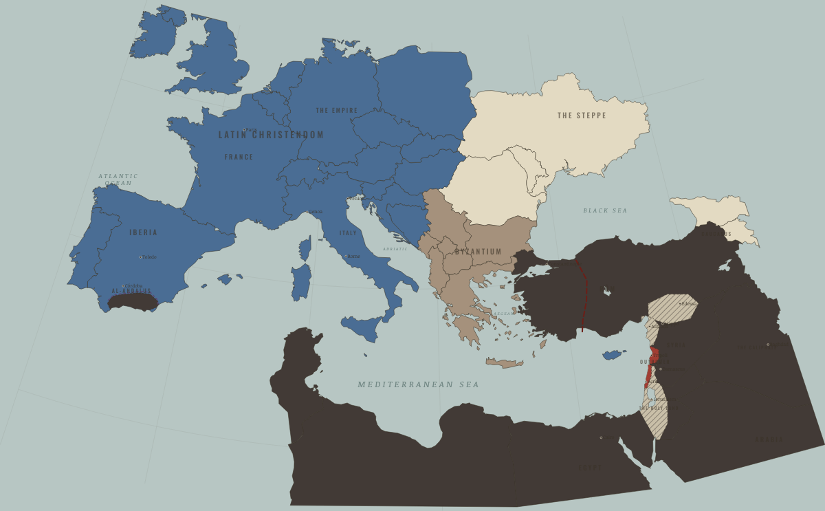
Map of the Crusades in 1271
After Baibars — Antioch gone, Krak fallen
The Crusades in 1271: After Baibars — Antioch gone, Krak fallen. The map shows who held what: Latin Christendom, The Islamic powers — Seljuk, Zengid, Ayyubid, Mamluk, Byzantium (and Latin Constantinople 1204–61).
1271 · THE CRUSADES, 1095–1291 These maps are reconstructed from published sources · Reuven Amitai-Preiss — Mongols and Mamluks · Cliopatria v0.2.1 — historical political boundaries · Simon Barton — Crusading in Iberia, c. 1060–1212 · The Metropolitan Museum of Art — Byzantium (ca. 330–1453) · The Metropolitan Museum of Art — The Crusades (1095–1291) · Natural Earth — physical reference geography · OpenStax — The Crusading Movement
Source details Reuven Amitai-Preiss, Cambridge University Press,1995. Historical event chronology consulted; no map or prose copied Cliopatria contributors / Seshat Global History Databank. CC BY 4.0 · Dated polygons selected; local transfers and shared frontier edges derived with documented historical event corrections. Simon Barton, The Cambridge History of the Crusades. Published summary consulted for dated conquests; no map copied The Metropolitan Museum of Art. Facts consulted; no prose or image copied Department of Medieval Art and The Cloisters, 2014. Facts consulted; no prose or image copied Natural Earth. Public domain OpenStax, World History Volume 1. CC BY 4.0 The source retains a Latin Empire beyond 1261. Its territory is assigned to restored Byzantine authority, while the remaining Latin principalities in Greece retain their own outlines.
For Syria after Ain Jalut, the source’s coarse 1260–1271 Mongol stage is corrected using the next local Mamluk Syrian outline.
Antioch is shown as lost after 1268, rather than retaining the source’s overlong 1260–1271 interval as an independent state.
At some ports, source coastlines have offsets of several kilometers at their resolution. The original polygons are preserved, and the review record gives explicit coastal anchor tolerances.
reconstruction: 1028–1325 · reconstruction: 1206–1271 · reconstruction: 1236–1271 · reconstruction: 1250–1271 · reconstruction: 1250–1278 · reconstruction: 1260–1271 · reconstruction: 1260–1278 · reconstruction: 1271 · reconstruction: post1268,1271 · vector: 1072–1325 · vector: 1188–1271 · vector: 1192–1362 · vector: 1202–1284 · vector: 1206–1271 · vector: 1206–1304 · vector: 1210–1304 · vector: 1236–1278 · vector: 1236–1284 · vector: 1236–1293 · vector: 1241–1271 · vector: 1250–1271 · vector: 1250–1278 · vector: 1250–1284 · vector: 1250–1293 · vector: 1250–1414 · vector: 1260–1271 · vector: 1260–1278 · vector: 1260–1284 · vector: 1260–1304 · vector: 1260–1384 · vector: 1260–1394 · vector: 1271
Layer records and reconstruction methods
On the ground the former Principality of Antioch, sacked by Baibars in 1268 the remaining coast, shrinking under Baibars The chapters of this moment
Related maps
◧ EMBED THIS MAP ON YOUR SITE
You may embed this map free if you keep the attribution link. Teachers can find print-ready
study guides at /study/ .
THE FREE PRINTABLE STUDY GUIDE
Get the printable study guide for The Crusades free. I’ll send you a few short letters, then one when a new atlas opens. That’s all. — Paul
NO TRACKING · YOUR ADDRESS IS USED FOR THE DISPATCH AND NOTHING ELSE ·
UNSUBSCRIBE ANYTIME