MAPS OF HISTORY · NORSE AND AZTECS · BATTLES AND EVENTS · Stöng longhouse, ÞjórsárdalurNorse and Aztecs · TURNING POINT · c. 1104
Stöng longhouse, Þjórsárdalur (c. 1104)
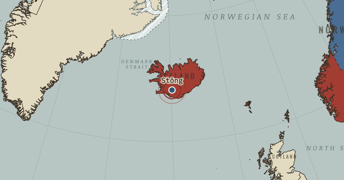
On the Norse and Aztecs map as “Stöng — Þjórsárdalur”
c. 1104 — Hekla’s ash buried farms across the valley of Þjórsárdalur, among them Stöng, whose turf longhouse is one of Iceland’s best known. Recent excavations suggest that people left the valley gradually into the thirteenth century, as erosion followed the eruption.
When c. 1104 Type Turning point Chapter Settlement of Iceland (chapter 3 of Norse and Aztecs)Atlas Climate and Innovation: The Norse and the Aztecs, c. 790–1521 TURNING POINT · CLIMATE AND INNOVATION: THE NORSE AND THE AZTECS, C. 790–1521 These maps are reconstructed from published sources · Natural Earth administrative references · Greenland National Museum: Anavik archaeological survey, p.11 · Cliopatria v0.2.1 historical polities · Norse Eastern Settlement: named farm distribution · GeoNames geographic controls · Ogilvie et al.2009: seals and sea ice in Norse Greenland · UNESCO: Kujataa archaeological landscape · Natural Earth v5.1.2 full geographic reference · Ljungqvist 2005: Norðrsetur and Disko Bay hunting · Hollesen et al.2016: Sandnes site coordinates · Sámi Parliament: the Sápmi homeland · Friesen and Arnold 2008: timing of the Thule migration · Norse Western Settlement: farm distribution
Source details Natural Earth contributors. Public domain Greenland National Museum: Anavik archaeological survey, p.11. Historical facts cited; no source artwork or prose reproduced Cliopatria contributors / Seshat Global History Databank. CC BY 4.0 Masae, based on Arneborg, Gulløv and Guðmundsson. CC BY-SA 3.0 GeoNames contributors. CC BY 4.0 Ogilvie et al.2009: seals and sea ice in Norse Greenland. Historical facts cited; no source artwork or prose reproduced UNESCO: Kujataa archaeological landscape. Historical facts cited; no source artwork or prose reproduced Natural Earth contributors. Public domain Ljungqvist 2005: Norðrsetur and Disko Bay hunting. Historical facts cited; no source artwork or prose reproduced Jørgen Hollesen and coauthors. CC BY 4.0 Sámi Parliament: the Sápmi homeland. Historical facts cited; no source artwork or prose reproduced Friesen and Arnold 2008: timing of the Thule migration. Historical facts cited; no source artwork or prose reproduced Masae, based on Arneborg, Gulløv and Guðmundsson. CC BY-SA 3.0 These maps are reconstructed from published sources. The layer record provides the source geometry, registration controls, reference dates and derivatives.
This map concerns settlement, voyages and the environment. Its geographic study regions are not all medieval state borders. Modern continental borders are dissolved, while the dated Danelaw and Normandy sources retain their historical meaning.
Greenland settlement references come from published farm distributions. The ice bands, coastal migration bands and voyage ranges are explanatory regions rather than measured medieval boundaries. The erroneous Cliopatria eastern Greenland placement was rejected.
Chapter date: 930. The actual source/reference date is recorded separately for each layer.
proxy: Later Dublin county-area reference · proxy: Published geographic reference; not a medieval administrative survey · reconstruction: Norse settlement distribution, c.985–1450 · reconstruction: Source-described ice exposure; explanatory band · reconstruction: Traditional Sápmi regional reference · vector: 926–935
Layer records and reconstruction methods
In the same chapter
Related
THE FREE PRINTABLE STUDY GUIDE
Get the printable study guide for Climate and Innovation free. I’ll send you a few short letters, then one when a new atlas opens. That’s all. — Paul
NO TRACKING · YOUR ADDRESS IS USED FOR THE DISPATCH AND NOTHING ELSE ·
UNSUBSCRIBE ANYTIME