Norse and Aztecs · CHAPTER 7 ·
Founding of Tenochtitlan
Chapter 7 of Climate and Innovation: The Norse and the Aztecs, c. 790–1521: “An Empire Built on a Lake”
Tradition places the founding of Tenochtitlan in 1325, when the Mexica settled in a lake in the Basin of Mexico, a high valley at about 2,240 metres with no outlet, where salty Lake Texcoco met fresh southern lakes. Their century serving Azcapotzalco ended with its fall in 1428 and a Triple Alliance formed to share tribute.
Chapter 7 is included with every paid plan. WW2 is free in full, and chapter 1 of every atlas is free. A free account opens 3 more chapters a day. Starter, at $9 a month, opens all 21 with no daily limit — see the plans.
Free printable Norse and Aztecs study guide, sent by email ↓
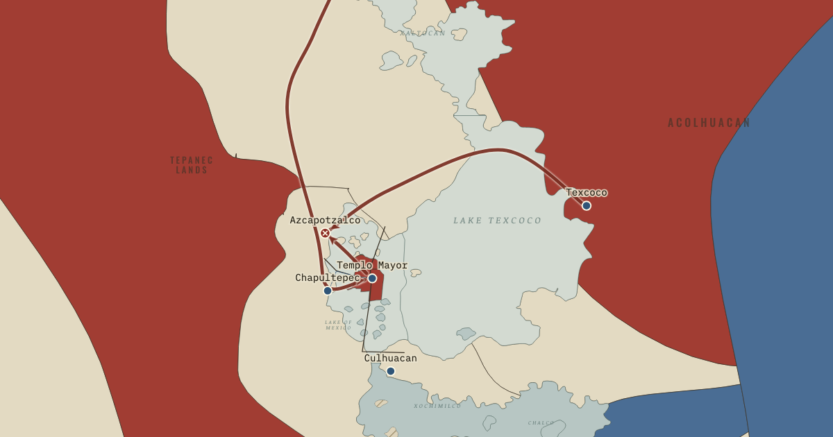
The map above is the world of The Basin of Mexico, 1428 — The Tepanec War and the Triple Alliance.
Part of IB History: The Norse and the Aztecs →
SHORT EXPLANATION
The Mexica built Tenochtitlan on islands in a lake that could both shelter and endanger them. The Basin of Mexico lies about 2,240 metres high, surrounded by mountains, and has no natural outlet. At high water its shallow lakes covered perhaps 1,000–1,500 square kilometres. Water collecting in low-lying Lake Texcoco escaped by evaporation, leaving salt behind; springs kept the southern lakes of Xochimilco and Chalco fresh. On the map, pale water marks salt and blue-grey fresh water. Frost threatened maize, and summer rains could fail or cause floods.
The Mexica, later called the Aztecs, came from the north as latecomers among stronger peoples. Around 1325 they founded their city in the western marshes. The lake provided food, protection and canoe routes where there were no draught animals, although the islands lacked fresh springs and were liable to flood. For a century the Mexica fought and paid tribute—regular payments in goods, like a tax—to the Tepanec kingdom of Azcapotzalco, shown in charcoal. In 1428 they joined Nezahualcoyotl of Texcoco and the Tepanec town of Tlacopan to overthrow it. Their Triple Alliance shared conquests and tribute like partners in a company. The red on the map shows how a refuge became the centre of an empire.
The full story
The Mexica arrived in a basin whose inhabitants already knew both the uses and the dangers of water. Depending on where its rim is drawn, the Basin of Mexico covers 7,500–9,600 square kilometres. Its lakes could join into one sheet in wet years and separate as they shrank in the dry season. Most rain fell from June to September; a late beginning or an early frost could ruin the maize harvest. Water draining into the lowest lake, Texcoco, left salt behind as it evaporated. Springs below the southern mountains supplied fresh water to Xochimilco and Chalco. People there had made chinampas, raised fields built from material piled up from the shallow lake bed. The newcomers inherited this knowledge as well as the basin’s uncertain rainfall.
Their own accounts tell how they came to occupy the marsh. Mexica chronicles describe a long migration from Aztlan, a stay at Chapultepec’s springs in the late thirteenth century, and expulsion by stronger neighbours around 1299 or later. They then served Culhuacan, until a violent break drove them onto the islands. Tradition dates Tenochtitlan’s founding to Two House, 1325: the Mexica calendar named years by combining numbers and signs. Around 1337 their kinsmen founded Tlatelolco on a neighbouring island. Later rulers reshaped these accounts, but they agree on the newcomers’ poverty and outsider status. They had to make a home on land others had left to them.
The founding image in the Codex Mendoza gives that beginning a different dignity. Painted by Indigenous artists for the Spanish viceroy after the conquest, it shows an eagle on a cactus at the centre of an island divided by canals. The image tells us how the city’s beginnings came to be presented; it also invites us to ask how people survived there before they possessed an empire.
The island site gave a weak community advantages. Armies found it defensible, canoes could reach the shores, and fish, waterfowl, insects, salt and edible green algae supplemented the little farmland. Drinking water was another matter: there were no springs on the islands. Canoes brought water from Chapultepec until a flimsy clay-and-reed channel was built under Chimalpopoca in the 1420s.
The Mexica lived under Azcapotzalco’s authority, paying tribute in goods and labour and fighting its wars. When its ruler Maxtla turned against them, Itzcoatl joined forces with Nezahualcoyotl, the exiled heir of Texcoco, and the Tepanec town of Tlacopan. Their victory in 1428 brought a new arrangement: the three cities shared conquest and tribute, rather like shareholders in a company. The people who had taken refuge in the marsh now held power over the lake and its shores.
FULL EXPLANATION
Reading the founding page of the Codex Mendoza
The Codex Mendoza’s first page is a founding story painted after the conquest, not a contemporary picture of 1325. Indigenous artists made it in Mexico City with Spanish commentary. It has traditionally been dated around 1541–42 and attributed to the patronage of Viceroy Antonio de Mendoza; Jorge Gómez Tejada has questioned both the date and the patron. It was certainly finished by 1553. At the centre, an eagle stands on a cactus growing from a rock. Blue diagonals divide a square island into four quarters, representing canals. Ten founding leaders surround it, as does a border of year signs beginning with Two House. Below are warriors conquering Culhuacan and Tenayuca. The arrangement presents an ordered city and Mexica rulers whose rise appears destined. That makes the page invaluable for studying the memory and politics of the founding a generation after conquest. It is much weaker evidence for what the marsh actually looked like.
The lake as resource and risk
A household beside the lakes could draw on much more than crops. Shallow water supported fish, frogs, salamanders, insect eggs and great flocks of migrating ducks. The Mexica dried the blue-green algae tecuitlatl into cakes, and salt boiled from Texcoco’s brine entered wide trade. Canoes carried loads that would have required many porters, a considerable advantage without wheeled transport or draught animals. Jeffrey Parsons and colleagues emphasized how lakeside societies spread risk among resources. If one source failed, others could still support them. Yet the lake itself remained uncertain: wet years could raise water over the islands, while drought could leave canals dry. Its productivity helped communities grow, and growth in turn put more people at the mercy of water no one could fully control.
The Tepanec War and the problem of the chronicles
Our accounts of the 1428 war were written largely after the Spanish conquest, by Indigenous nobles and Spanish friars with loyalties to particular cities and lineages. Their differences matter when we ask who deserves credit. Diego Durán and Hernando Alvarado Tezozómoc used a lost Nahuatl history probably written by descendants of the Mexica adviser Tlacaelel; their account places him at the centre of victory and the empire that followed. Fernando de Alva Ixtlilxochitl, a descendant of Nezahualcoyotl, gives Texcoco a larger part. Susan Schroeder’s study of the Tlacaelel tradition and Camilla Townsend’s reading of the Nahuatl annals caution us about such partisan memories. The chronicles nevertheless agree on the broad course: Mexica vassalage to Azcapotzalco, a succession crisis under Maxtla, a coalition of Tenochtitlan, Texcoco and dissident Tepanecs, and the sack of Azcapotzalco in 1428. Victory did not immediately settle the new partnership. Nezahualcoyotl was restored in Texcoco in 1431, and historians place the formation of a working alliance in the early 1430s. The decisive victory and the completed settlement were separate stages.
Key places on the map
Why it happened
A closed basin made salt and floods inevitable. Water draining from the mountains had no river outlet from the basin. Evaporation removed water and left salts, especially in low-lying Texcoco; in wet years the level of the connected lakes rose. Settlers could use the lakes, but they also had to contend with salt and floods. These conditions would shape Mexica engineering for a century.
Latecomers took the marginal land. Established cities such as Azcapotzalco, Culhuacan and Texcoco already held the best farmland on the shores when the Mexica arrived in the thirteenth century. After expulsion from Chapultepec and Culhuacan, the newcomers found refuge on islands in the western marshes that others had not claimed. Their later power grew out of this weakness, helping explain the value they placed on military service and organised labour.
Service to Azcapotzalco taught war and politics. Azcapotzalco’s authority imposed tribute and military service on the Mexica for about a century. Campaigns across the basin gave them experience, while marriages connected them to powerful families. They also saw how a dominant city drew tribute from others. When Tezozomoc died in 1426 and his Tepanec kingdom split, that experience could be turned against their overlords.
An alliance of the threatened. Maxtla’s enemies had reasons to set rivalry aside. He threatened the Mexica and Nezahualcoyotl, whose father the Tepanecs had killed in 1418; some Tepanec towns, including Tlacopan, also opposed him. A common danger brought them together. Like later alliances formed against a shared enemy, their coalition would become an instrument of expansion.
THE TURNING POINT
The fall of Azcapotzalco, 1428. Azcapotzalco’s sack in 1428 ended the Mexica’s position as vassals. With Texcoco and Tlacopan, they gained the Tepanec kingdom’s lands and tribute and authority to organise labour around the basin. This mattered for more than conquest. The dikes, aqueducts and chinampas of the following decades needed thousands of workers from many towns. Power over the shores made such work possible.
What it changed
A Triple Alliance to share tribute. The partners campaigned together and, according to later chronicles, divided tribute in shares: two-fifths each for Tenochtitlan and Texcoco, one-fifth for Tlacopan. Within a few years they subdued Xochimilco, Cuitlahuac and other southern lake towns. The alliance gained both the basin’s best chinampa land and the labour of those who farmed it.
Engineering the lake becomes possible. Rulers who could call workers from towns around the lake could attempt larger defences and water supplies. Chapter 8 follows two such works: the masonry aqueduct from Chapultepec and Nezahualcoyotl’s great dike of about 1449. Their labour depended on the political power gained in 1428.
Expansion beyond the basin. Azcapotzalco’s defeat gave the alliance access to tribute networks beyond the basin. Itzcoatl and his successor Moctezuma I then sent campaigns south into Morelos and north into Otomí lands. The growing empire would bring maize, beans and cloth to Tenochtitlan from hundreds of kilometres away, while creating enemies as well.
DISCUSSION QUESTION — Was the lake more of an advantage or a burden to the Mexica in their first century?
For the small and vulnerable community of the first century, the lake was mostly an advantage. It offered protection, food and canoe transport, allowing numbers to grow despite scarce farmland and the absence of draught animals. The islands had no springs, however, and the closed basin brought salt and flooding. Those burdens remained manageable while the city was small and under Tepanec rule, with no large labour force at its command. After 1428, power over the shores let the Mexica enlarge the city and engineer the water. More people could benefit from the lake, but more also depended on its uncertain level.
An interesting fact
The Codex Mendoza reached Oxford by a circuitous route. Samuel Purchas reported that French privateers captured it on its way to Spain. It came into the hands of André Thevet, cosmographer to the French king, who signed it in 1553. The English geographer Richard Hakluyt bought it in Paris, and Purchas published woodcuts of its pages in 1625. Later it belonged to John Selden, whose books entered Oxford’s Bodleian Library in the 1650s. It remains there as MS. Arch. Selden. A. 1.
Related
THE FREE PRINTABLE STUDY GUIDE
Get the printable study guide for Climate and Innovation free. I’ll send you a few short letters, then one when a new atlas opens. That’s all. — Paul
NO TRACKING · YOUR ADDRESS IS USED FOR THE DISPATCH AND NOTHING ELSE · UNSUBSCRIBE ANYTIME