MAPS OF HISTORY · ON THIS DAY · October 27 · 1947
ON THIS DAY · 27 OCTOBER 1947
Srinagar — the accession
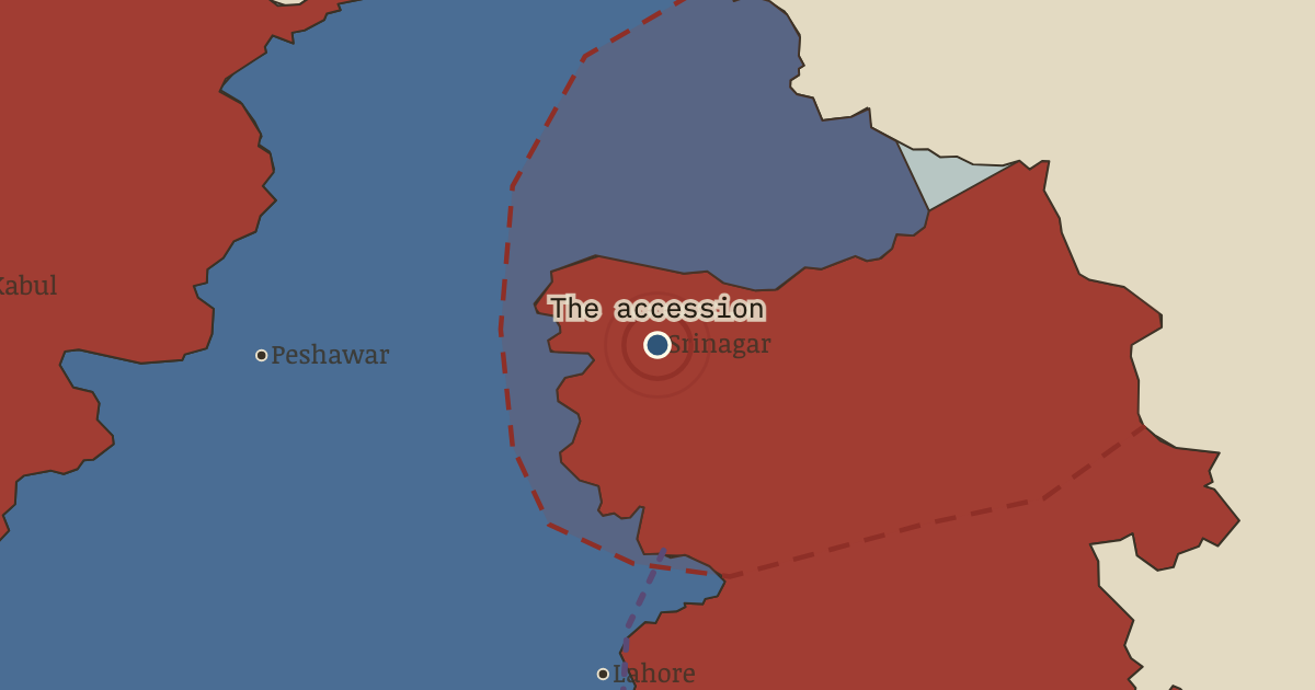
26–27 Oct 1947 — With raiders forty miles away, Maharaja Hari Singh signs Kashmir over to India; Indian troops land at dawn on the airfield. Whether the signature or the landing came first is still argued; the dispute it opened has never closed.
THE MOMENT IN CONTEXT
Accession was the legal act by which a princely ruler joined one dominion, handing over a defined set of powers, and after independence three of these states remained unresolved. Junagadh had a Muslim ruler and a Hindu-majority population, and when its nawab acceded to distant Pakistan, India blockaded the state, the nawab fled to Karachi, and a later plebiscite confirmed Indian control. Hyderabad, the largest princely state, held out for independence until Indian troops ended the standoff in five days in September 1948, after which communal killings followed that an official inquiry put in the tens of thousands. Kashmir had a Hindu maharaja, a Muslim-majority population and borders with both dominions. In October 1947 a tribal lashkar from the frontier, armed and led in part by Pakistani officers, advanced on Srinagar, and its sack of Baramulla delayed it just long enough for Hari Singh to sign the Instrument of Accession to India and for Indian troops to land. Fourteen months of war ended with a UN-brokered ceasefire on 1 January 1949, a line that divided Kashmir while settling neither its sovereignty nor the rival principles of accession and popular will.
From Chapter 12 — The Price and the Legacy of Indian Independence & Partition, 1905–1948 (FEB 1948).
OPEN THE INTERACTIVE MAP →New here? Chapters 1–2 of every atlas are free to sample, and the WW2 atlas is free in full. One membership opens all thirteen — the Cartographer’s Circle.
TEACH THIS IN 5 MINUTES
- Why it happened — Three holdouts, one doctrine. Paramountcy’s lapse left accession to the rulers, not the ruled — so Junagadh’s nawab, Hyderabad’s nizam and Kashmir’s maharaja each chose against…
- The turn — Birla House, 30 January 1948. Three shots at a prayer meeting, and the era acquires its full and final shape: the movement’s founder killed not by the empire he defeated but by a…
- What it changed — Two constitutions from one struggle. India’s constituent assembly, its drafting committee chaired by Ambedkar — the Poona Pact’s wounded party now the framer — produced in 1950 a…
Then ask the room: Fifteen million displaced, hundreds of thousands to two million dead — and four hundred million freed. Was Partition the price of freedom, or a separate catastrophe that freedom’s mismanagement allowed? The argued answer is on the chapter page →
THE ATLAS THAT SHOWS IT
THE DISPATCH
One short letter when a new atlas opens — and the printable study guide for Indian Independence & Partition is yours now, free.
NO TRACKING · YOUR ADDRESS IS USED FOR THE DISPATCH AND NOTHING ELSE · UNSUBSCRIBE ANYTIME