MAPS OF HISTORY · ON THIS DAY · SEPTEMBER 27 · Tripartite Pact (1940)ON THIS DAY · 27 SEPTEMBER 1940
Tripartite Pact
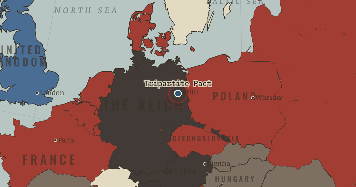
27 Sep 1940 — Germany, Italy and Japan sign a mutual-defense pact in Berlin. It is aimed at keeping America out of the wars in both oceans. The Axis has become a world system.
27 SEPTEMBER 1940 · THE ROAD TO WAR, 1931–1941 These maps are reconstructed from published sources · Cliopatria v0.2.1 — dated political boundaries · Australian War Memorial — fall ofGondar and end ofItalian control,November1941 · Regional history institute — Italian annexations of1941, Fiume province and Krk · United States Holocaust Memorial Museum — German territorial expansion · IGM Fiume, 1:25,000, sheet53B II SE — boundary established in1924 · Natural Earth — physical reference geography · Yugoslavia (1929–1939) location map — international frontier and Adriatic coast · Treaty of Rome (1924), division of Fiume and west-bank boundary · Murli / rowanwindwhistler — Slovakia border changes, 1938–1945 · United States Holocaust Memorial Museum — The Holocaust in Slovakia · US Military Academy — The War in Eastern Europe (1952), maps7 and15 · Slovak Nation’s Memory Institute — The First Vienna Award
Source details Cliopatria contributors / Seshat Global History Databank. CC BY4.0 · Dated polity and constituent territory selections; campaign-dependent occupation overlays reconstructed separately. Australian War Memorial — fall ofGondar and end ofItalian control,November1941. Historical facts consulted; no source artwork or prose republished Regional history institute — Italian annexations of1941, Fiume province and Krk. Historical geographic facts consulted; source prose and artwork not republished United States Holocaust Memorial Museum. Historical dates consulted; no prose or image copied Istituto Geografico Militare, Fiume (printed1946; 1927 survey with1931–1940 updates), reproduced by Istituto regionale per la storia della Resistenza e dell’Età contemporanea nel Friuli Venezia Giulia. Independent reconstruction from graticule coordinates and boundary observations; archive page reserves artwork rights.. Geographical-fact reconstruction; original archive artwork not distributed Natural Earth. Public domain NordNordWest/Wikipedia. Converted from the published SVG to WGS84; eastern Italian regional territory extracted. Source cites Velhagen & Klasings Großer Volksatlas (1938).. CC BY-SA 3.0 Germany 1924 agreement interpreted alongside the regional history institute and City of Rijeka’s explanation of the Donja/Gornja Drenova division.. Historical geographic facts; citation only Murli; SVG adaptation by rowanwindwhistler (2021). CC BY-SA 2.5; derived geographic paths under the same license · Georeferenced actual published vector regions using eight printed city positions; no map artwork or labels in the atlas. United States Holocaust Memorial Museum — The Holocaust in Slovakia. Historical chronology consulted; no source prose or artwork republished Department of Military Art and Engineering, United States Military Academy,1952. US federal government work; public domain maps Slovak Nation’s Memory Institute — The First Vienna Award. Historical territorial chronology consulted; no source artwork or prose republished The June–December 1941 chapter uses the front of 6 December 1941, matching its final campaign phase.
The published Free French polity is assigned to the Allied side. Its separate territory does not inherit the occupied status of metropolitan France.
Slovak territory is reconstructed from the published 1938–1945 border-change map, distinguishing the client state from Hungarian and German annexations. Small northern frontier changes and survey-level detail lie outside this regional source. After August 1944, German military occupation supersedes the client-state fill.
The eastern Italian frontier uses the published 1930s regional map and a 1924 Fiume boundary reconstruction. Source conquests after April 1941 remain separately dated.
reconstruction: 1922–1952 · reconstruction: 1936–1941 · reconstruction: 1936–1942 · reconstruction: 1938-10 · reconstruction: 1939 · reconstruction: 1939-03 · reconstruction: 1940-06 · reconstruction: 1940–1941 · reconstruction: 1940–1942 · reconstruction: 1941-12-06 · reconstruction: 1941.5 · reconstruction: 1941–1941 · trace: 1941-12-06 · vector: 1895–1941 · vector: 1912–1955 · vector: 1918–1941 · vector: 1936–1941 · vector: 1936–1944 · vector: 1936–1945 · vector: 1936–1986 · vector: 1938–1972 · vector: 1939–1944 · vector: 1939–2023 · vector: 1940–1941 · vector: 1940–1942 · vector: 1940–1943 · vector: 1941–1941 · vector: 1941–1943
Layer records and reconstruction methods
The moment in context Mussolini wanted Italy to fight a “parallel war” and acquire conquests without depending on Germany. The campaigns in Greece and North Africa produced the opposite result. Germany sent troops to Libya and conquered Yugoslavia and Greece in spring 1941. The intervention consumed time, but historians disagree about its effect on the date of Barbarossa: unusually wet weather and the task of assembling forces and supplies also constrained the timetable.
From Road to Operation Barbarossa , chapter 11 of The Road to War, 1931–1941 (1941).
The place: Tripartite Pact — map and full story →
Teach this in 5 minutes Why it happened — Hitler’s eastern program. The attack fulfilled an ambition Hitler had long expressed. In Mein Kampf and at the Hossbach conference (Ch. 5), he sought eastern Lebensraum;…The turn — Berlin, 27 September 1940. At the ● in Berlin, Germany, Italy and Japan signed the Tripartite Pact on 27 September 1940. Each pledged mutual assistance against a power not yet…What it changed — Mass murder behind the front. The advancing armies made occupied territory available to the Einsatzgruppen, Order Police and local auxiliaries, who carried out systematic mass…Then ask the room: Could Barbarossa have succeeded — and what turns on the answer? The argued answer is on the chapter page →
The atlas that shows it
THE FREE PRINTABLE STUDY GUIDE
Get the printable study guide for The Road to War free. I’ll send you a few short letters, then one when a new atlas opens. That’s all. — Paul
NO TRACKING · YOUR ADDRESS IS USED FOR THE DISPATCH AND NOTHING ELSE ·
UNSUBSCRIBE ANYTIME