MAPS OF HISTORY · ON THIS DAY · AUGUST 14 · Equalisation of Burdens Act (1952)ON THIS DAY · 14 AUGUST 1952
Equalisation of Burdens Act
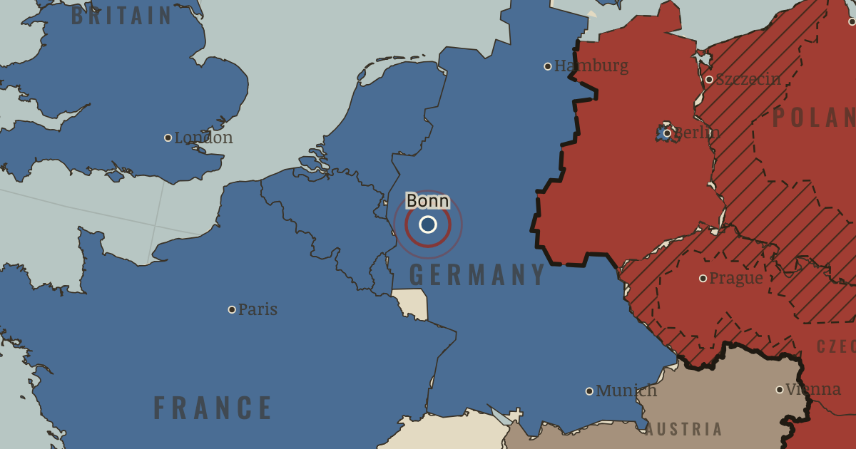
14 Aug 1952 — The Bundestag passes the Lastenausgleich law to compensate expellees and people whose homes were bombed out. Owners of property that survived the war pay half its 1948 value into a fund, with payments spread over thirty years. By 1986 the fund has paid out more than 130 billion marks, making it one of the largest transfers of wealth in West German history.
14 AUGUST 1952 · UPROOTED: REFUGEES IN EUROPE 1945–1960 AND INDOCHINA 1975–1990 These maps are reconstructed from published sources · Geoportal Berlin: official locality polygons · Berlin State Heritage Office: four sectors1945–1948 · The rise and fall of the Berlin Wall · Cliopatria v0.2.1 historical polities · Decolonization of Asia and Africa, 1945–1960 · Occupation and reconstruction of Germany, 1945–1948 · Natural Earth v5.1.2 country geography · Natural Earth administrative references · 1947 Treaty of Peace with Italy, Articles3,11,22 · Potsdam Protocol: administration and population transfers · UNHCR: The State of the World’s Refugees2000 · Polish Institute of National Remembrance: Operation Vistula · Cliopatria v 0.2.1 — dated political boundaries · United States Holocaust Memorial Museum — German territorial expansion · IGM Fiume, 1:25,000, sheet53B II SE — boundary established in1924 · Yugoslavia (1929–1939) location map — international frontier and Adriatic coast · Treaty of Rome (1924), division of Fiume and west-bank boundary
Source details Geoportal Berlin / ALKIS Berlin Ortsteil. Datenlizenz Deutschland Zero2.0 Berlin State Heritage Office: four sectors1945–1948. Historical facts cited; no source artwork or text reproduced US government historical publication. Historical facts cited; no source artwork or prose reproduced Cliopatria contributors / Seshat Global History Databank. CC BY 4.0 · Selected dated records; documented component selection, unions and shared-edge extraction. US Department of State, Office of the Historian. US government publication National Army Museum. Historical facts cited; no source artwork or prose reproduced Natural Earth contributors. Public domain · Full source components and holes retained; documented historical unions and repairs. Natural Earth contributors. Public domain 1947 Treaty of Peace with Italy, Articles3,11,22. Historical facts cited; no source artwork or text reproduced Potsdam Protocol: administration and population transfers. Historical facts cited; no source artwork or text reproduced UNHCR: The State of the World’s Refugees2000. Historical facts cited; no source artwork or text reproduced Polish Institute of National Remembrance: Operation Vistula. Historical facts cited; no source artwork or text reproduced Cliopatria contributors / Seshat Global History Databank. CC BY4.0 · Dated polity and constituent territory selections; campaign-dependent occupation overlays reconstructed separately. United States Holocaust Memorial Museum. Historical dates consulted; no prose or image copied Istituto Geografico Militare, Fiume (printed1946; 1927 survey with1931–1940 updates), reproduced by Istituto regionale per la storia della Resistenza e dell’Età contemporanea nel Friuli Venezia Giulia. Independent reconstruction from graticule coordinates and boundary observations; archive page reserves artwork rights.. Geographical-fact reconstruction; original archive artwork not distributed NordNordWest/Wikipedia. Converted from the published SVG to WGS84; eastern Italian regional territory extracted. Source cites Velhagen & Klasings Großer Volksatlas (1938).. CC BY-SA 3.0 Germany 1924 agreement interpreted alongside the regional history institute and City of Rijeka’s explanation of the Donja/Gornja Drenova division.. Historical geographic facts; citation only Territories and displacement hatching are reconstructed from published source geometry. The hatched areas locate historical regions; ethnicity, displacement and control were not necessarily uniform at every point within them.
The layer records give the full source geometry and date choices. Arrows remain schematic routes, using the lesson’s existing volume categories.
Where a 1945 vector was unavailable, German occupation/state boundaries use the nearest 1949/1950 sources. Berlin’s sector-area reference uses official later locality boundaries, leaving small historical exchanges unresolved. The 1961 wall view uses actual 1989 wall segments as an explicitly later reference.
Prewar German, Polish, Finnish and Italian source polygons identify regions of transfer and expulsion. For Istria, the reference combines the published 1929–1939 Italian eastern outline and an IGM Fiume reconstruction with postwar Yugoslav geography. It shows the 1943–1956 exodus region, including the later 1954 Zone B adjustment. The 1947 peace treaty entered into force in September; the hatch does not show a treaty-day or April 1947 sovereignty line.
Chapter narrative date: 1956.88; each selected source records its own reference interval.
proxy: Later administrative references to1947affected regions · proxy: Natural Earth v5.1.2 geographic reference · reconstruction: 1937territories / postwar successor references · reconstruction: 1938-10 · reconstruction: 1945–1990eastern sector; later locality perimeters · reconstruction: 1945–1990western sectors; later locality perimeters · reconstruction: 1945–1991 · reconstruction: 1945–1991 geographic union · reconstruction: 1950–1957 · reconstruction: 1953–1972 · reconstruction: Postwar Yugoslav reference · reconstruction: Postwar division reference · vector: 1949–1952
Layer records and reconstruction methods
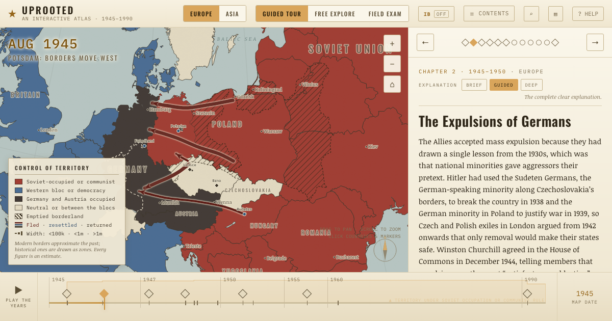
The moment in context In 1950 one West German resident in six was an expellee. Many were crowded into barracks and farm attics in Schleswig-Holstein, Lower Saxony and Bavaria. Industrial jobs lay elsewhere, and local people sometimes met the newcomers with open hostility. Citizenship gave the expellees a claim on the state, but it did not by itself give them a house or a livelihood.
From Expellee integration in West Germany , chapter 6 of Uprooted: Refugees in Europe 1945–1960 and Indochina 1975–1990 (1956).
The place: Equalisation of Burdens Act — map and full story →
Teach this in 5 minutes Why it happened — Citizens with a vote. Expellees in West Germany had a political resource stateless DPs lacked: citizenship. They could vote, organize and stand for office. About one…The turn — The bridge at Andau, November 1956. The small bridge over the canal at Andau carried people fleeing Hungary until Soviet engineers destroyed it on 21 November 1956. Their journey…What it changed — A template for burden-sharing. Austria's reception of Hungarians and other countries' offers of permanent homes formed a model for sharing responsibility. The July 1979 Geneva…Then ask the room: How far was the integration of West Germany’s expellees the result of deliberate government policy? The argued answer is on the chapter page →
The atlas that shows it
THE FREE PRINTABLE STUDY GUIDE
Get the printable study guide for Uprooted free. I’ll send you a few short letters, then one when a new atlas opens. That’s all. — Paul
NO TRACKING · YOUR ADDRESS IS USED FOR THE DISPATCH AND NOTHING ELSE ·
UNSUBSCRIBE ANYTIME