MAPS OF HISTORY · ON THIS DAY · JULY 1 · First day on the Somme (1916)ON THIS DAY · 1 JULY 1916
First day on the Somme
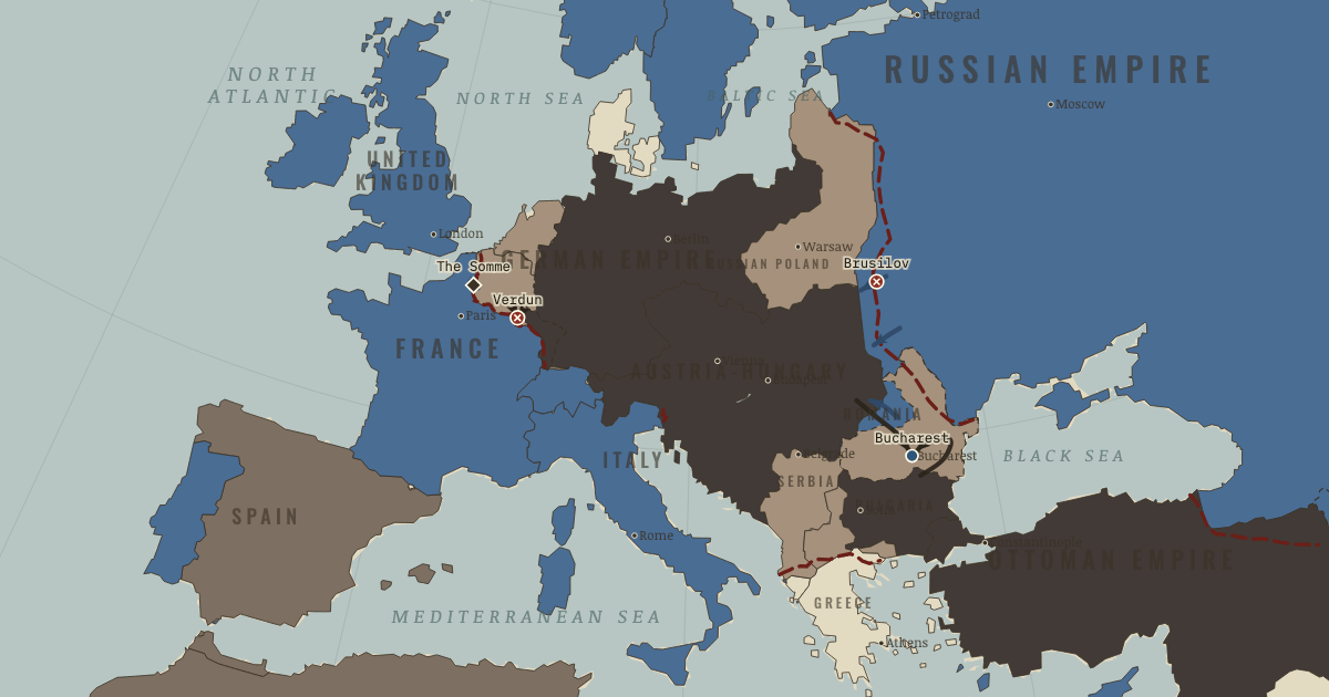
The first day of the Somme: 57,000 British casualties before nightfall, the bloodiest day in that army’s history.
1 JULY 1916 · THE GREAT WAR, 1871–1923 These maps are reconstructed from published sources · Caucasus Front, 1914–1918 Online · Cliopatria v 0.2.1 · Natural Earth physical geography · Anglo-Russian Convention, 31 August 1907, articles I–II · Maps of History: Great War geographic decisions · National Army Museum: Salonika campaign · US Military Academy World War I atlas, chart 11 · US Military Academy World War I atlas, chart 14 · US Military Academy World War I atlas, chart 39 · US Military Academy World War I atlas, chart 41
Source details Tigran Martirosyan, University of Amsterdam; Russian 1916 advance, Erzincan and Bitlis geographic extent.. Historical geographic facts cited; no map copied Cliopatria contributors / Seshat Global History Databank. Source polygons retained with original identities; geographic selections and corrections by Maps of History.. CC BY 4.0 Made with Natural Earth; geographic reference and physical land only. No modern political boundary is used as a historical boundary.. Public domain US Department of State, Foreign Relations of the United States; convention’s named places define the two concession spheres.. Historical treaty facts, independently reconstructed Maps of History. Campaign-sector connectors and contextual regions are identified separately from imported vector outlines.. Original geographic reconstruction using attributed historical evidence National Army Museum: late 1916 Albanian coast–Monastir–Doiran–Struma line and 1918 liberation campaign.. Historical evidence citation; no artwork copied US Military Academy, Department of History & War Studies, World War I chart 11. Selected geographic front facts reconstructed independently; no claim of blanket public-domain artwork rights.. Geographic evidence citation; source index requests permission for map reprints. Original artwork is not redistributed. US Military Academy, Department of History & War Studies, World War I chart 14. Selected geographic front facts reconstructed independently; no claim of blanket public-domain artwork rights.. Geographic evidence citation; source index requests permission for map reprints. Original artwork is not redistributed. US Military Academy, Department of History & War Studies, World War I chart 39. Selected geographic front facts reconstructed independently; no claim of blanket public-domain artwork rights.. Geographic evidence citation; source index requests permission for map reprints. Original artwork is not redistributed. US Military Academy, Department of History & War Studies, World War I chart 41. Selected geographic front facts reconstructed independently; no claim of blanket public-domain artwork rights.. Geographic evidence citation; source index requests permission for map reprints. Original artwork is not redistributed. Annual source features can describe claims, legal territory or military control. Occupied extensions are separated from the prewar Central Power homelands, while the original source names and shapes remain available.
The area east/north of the sourced western front is selected within the 1914 historical French, Belgian and Luxembourg footprints. It represents military control, not annexation.
The displayed state is iss 16. Geographic reference dates and reconstruction methods are recorded for each feature.
reconstruction: 1 January 1917 reference for late 1916–1917 · reconstruction: 1871–1918 · reconstruction: 1916.92 · reconstruction: 31 August 1907 · reconstruction: January 1915–December 1916 chart; principal 1915 line · reconstruction: June 1915 first-battle reference · reconstruction: Late 1916 Russian advance reference · reconstruction: Late 1916 allied line · reconstruction: Late 1916 versus 1917 source control
Layer records and reconstruction methods
The moment in context Why did Germany choose Verdun? The fortress city had political and emotional importance for France, and Falkenhayn expected the French to fight for it. His later memorandum described an intention to drain French manpower, although historians dispute the document and its relation to his original plan. The French did defend Verdun, but German losses mounted too. Pétain kept supplies moving along the road to the city and rotated divisions through the battle, spreading its burden across much of the French army.
From Verdun, the Somme and Brusilov , chapter 7 of The Great War, 1871–1923 (NOV 1916).
Teach this in 5 minutes Why it happened — The bargain at Verdun. The attritional interpretation of Verdun depended on France losing men faster than Germany. That exchange was difficult to secure when German troops…The turn — Verdun holds; German command changes. By July the fighting at Verdun had failed to produce the favorable exchange associated with Falkenhayn's later account. He was dismissed in August.…What it changed — Losses and resources. The estimated losses are staggering: roughly 300,000 dead at Verdun, another 300,000 on the Somme, and perhaps a million Austro-Hungarian and…Then ask the room: Could attrition be a rational strategy in 1916? The argued answer is on the chapter page →
The atlas that shows it
THE FREE PRINTABLE STUDY GUIDE
Get the printable study guide for WWI free. I’ll send you a few short letters, then one when a new atlas opens. That’s all. — Paul
NO TRACKING · YOUR ADDRESS IS USED FOR THE DISPATCH AND NOTHING ELSE ·
UNSUBSCRIBE ANYTIME