Remaking the State: Meiji Japan 1600–1912 and Post-Soviet Russia 1964–2000 · THE MAP IN
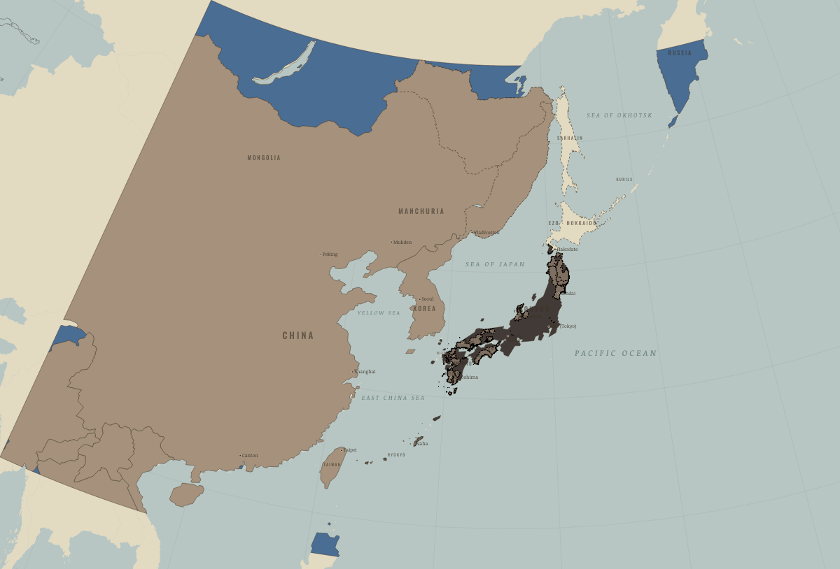
Map of Japan in 1840
Tokugawa Japan before the Opium War
Japan in 1840: Tokugawa Japan before the Opium War. The map shows who held what: Independent neighbours, Western powers and allies, The shogun’s lands and allies.
WW2 is free in full, and chapter 1 of every atlas is free. A free account opens 3 more chapters a day. Starter, at $9 a month, opens all 21 with no daily limit — see the plans.
Free printable Meiji Japan and post-Soviet Russia study guide, sent by email ↓
On the ground
- Japan was a patchwork of roughly 260 domains. Charcoal shows the shogun’s lands and loyal houses; grey-tan shows the outer lords on the rim.
- The domains survived under the emperor until 1871. The former shogunal lands, marked red, were governed directly from Tokyo.
- Outer Manchuria belonged to the Qing until the treaties of Aigun in 1858 and Peking in 1860.
- The Ussuri coast was held jointly from 1858. It became Russian in 1860, the year Vladivostok was founded.
- Japan and Russia both claimed Sakhalin, the lands of the Ainu, Nivkh and Uilta. The island was left undivided in 1855 and became Russian in 1875.
- Ezo was the Ainu homeland, where the Matsumae domain monopolized trade. Renamed Hokkaido in 1869, it was colonized from that year.
- The southern Kurils were Ainu islands under Japanese administration. In 1855, the Treaty of Shimoda set the border north of Etorofu.
- The Ryukyu kingdom was both a vassal of Satsuma and a tributary of China. It was annexed as Okinawa Prefecture in 1879.
Related maps
THE FREE PRINTABLE STUDY GUIDE
Get the printable study guide for Remaking the State free. I’ll send you a few short letters, then one when a new atlas opens. That’s all. — Paul
NO TRACKING · YOUR ADDRESS IS USED FOR THE DISPATCH AND NOTHING ELSE · UNSUBSCRIBE ANYTIME