MAPS OF HISTORY · ANCIENT ROME · BATTLES AND EVENTS · Palmyrene EmpireAncient Rome · TURNING POINT · 270
Palmyrene Empire (270)
On the Ancient Rome map as “Zenobia’s Palmyra”
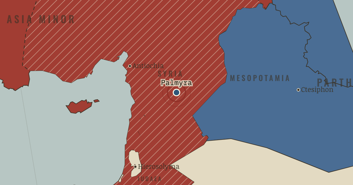
AD 270 — Zenobia, queen of the caravan city of Palmyra, conquers Egypt and reaches Ankara in Anatolia. She acts first in Rome’s name, then in her own. Her territory appears as the hatched east on the map.
When AD 270 Type Turning point Chapter Crisis of the Third Century (chapter 8 of Ancient Rome)Atlas The Rise and Fall of Rome, 264 BC – AD 476 TURNING POINT · THE RISE AND FALL OF ROME, 264 BC – AD 476 These maps are reconstructed from published sources · Cliopatria v0.2.1 · English Heritage: Hadrian’s Wall facts and FAQs · The Metropolitan Museum: Palmyra · Natural Earth physical coastlines and rivers · Pleiades: ancient places and Hadrian’s Wall forts · UNESCO: Frontiers of the Roman Empire
Source details Cliopatria contributors / Seshat Global History Databank. Selected, combined, and reprojected by Maps of History; dated adjustments are recorded per layer.. CC BY 4.0 English Heritage, facts checked by Dr Frances McIntosh (2026): wall endpoints and fort sequence.. Historical evidence citation; no copyrighted map traced Department of Ancient Near Eastern Art, The Metropolitan Museum of Art (2000).. Historical evidence citation; no prose or map copied Made with Natural Earth. Modern physical geography is a coastline/river reference, not evidence of ancient sovereignty.. Public domain Pleiades contributors; A. S. Esmonde Cleary, R. Talbert and subsequent editors (individual record credits retained in the review). Wall route reconstructed through published fort locations.. CC BY 3.0 UNESCO World Heritage Centre: frontier-system identification and dates.. Historical evidence citation; no map copied Palmyra is shown using a nearby source outline, with its political date explicitly corrected.
Displayed geometry: 271 (s271); chapter framing: 271. The map shows the moment selected for the chapter, even when the chapter spans several events.
proxy: AD265–269 source used for AD271 · reconstruction: 271 · reconstruction: AD122 onward · reconstruction: AD271 · reconstruction: Modern physical shoreline reference · reconstruction: Roman Rhine–Danube frontier system; changing over time · vector: -630 to 337 · vector: 106 to 370 · vector: 207 to 298 · vector: 224 to 346 · vector: 261 to 282 · vector: 265 to 305 · vector: 270 to 282 · vector: 270 to 307 · vector: 270 to 401 · vector: 78 to 370
Layer records and reconstruction methods
In the same chapter
Related
THE FREE PRINTABLE STUDY GUIDE
Get the printable study guide for Rome free. I’ll send you a few short letters, then one when a new atlas opens. That’s all. — Paul
NO TRACKING · YOUR ADDRESS IS USED FOR THE DISPATCH AND NOTHING ELSE ·
UNSUBSCRIBE ANYTIME