MAPS OF HISTORY · ANCIENT ROME · BATTLES AND EVENTS · Gallic EmpireAncient Rome · TURNING POINT · 260
Gallic Empire (260)
On the Ancient Rome map as “The Gallic Empire”
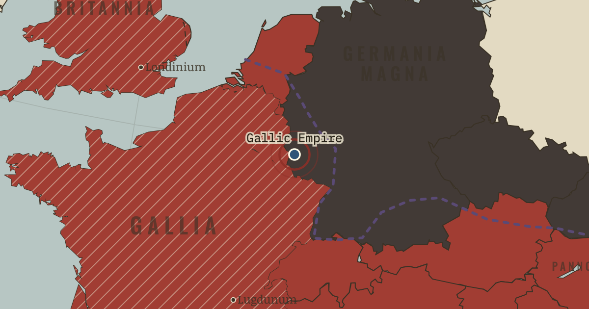
AD 260 — At Trier, Postumus, a commander on the Rhine, is proclaimed emperor. Gaul and Britain obey him, as does Spain for a time. The hatched west on the map shows the territory answering to him rather than Rome.
When AD 260 Type Turning point Chapter Crisis of the Third Century (chapter 8 of Ancient Rome)Atlas The Rise and Fall of Rome, 264 BC – AD 476 TURNING POINT · THE RISE AND FALL OF ROME, 264 BC – AD 476 These maps are reconstructed from published sources · Cliopatria v0.2.1 · English Heritage: Hadrian’s Wall facts and FAQs · The Metropolitan Museum: Palmyra · Natural Earth physical coastlines and rivers · Pleiades: ancient places and Hadrian’s Wall forts · UNESCO: Frontiers of the Roman Empire
Source details Cliopatria contributors / Seshat Global History Databank. Selected, combined, and reprojected by Maps of History; dated adjustments are recorded per layer.. CC BY 4.0 English Heritage, facts checked by Dr Frances McIntosh (2026): wall endpoints and fort sequence.. Historical evidence citation; no copyrighted map traced Department of Ancient Near Eastern Art, The Metropolitan Museum of Art (2000).. Historical evidence citation; no prose or map copied Made with Natural Earth. Modern physical geography is a coastline/river reference, not evidence of ancient sovereignty.. Public domain Pleiades contributors; A. S. Esmonde Cleary, R. Talbert and subsequent editors (individual record credits retained in the review). Wall route reconstructed through published fort locations.. CC BY 3.0 UNESCO World Heritage Centre: frontier-system identification and dates.. Historical evidence citation; no map copied Palmyra is shown using a nearby source outline, with its political date explicitly corrected.
Displayed geometry: 271 (s271); chapter framing: 271. The map shows the moment selected for the chapter, even when the chapter spans several events.
proxy: AD265–269 source used for AD271 · reconstruction: 271 · reconstruction: AD122 onward · reconstruction: AD271 · reconstruction: Modern physical shoreline reference · reconstruction: Roman Rhine–Danube frontier system; changing over time · vector: -630 to 337 · vector: 106 to 370 · vector: 207 to 298 · vector: 224 to 346 · vector: 261 to 282 · vector: 265 to 305 · vector: 270 to 282 · vector: 270 to 307 · vector: 270 to 401 · vector: 78 to 370
Layer records and reconstruction methods
In the same chapter
Related
THE FREE PRINTABLE STUDY GUIDE
Get the printable study guide for Rome free. I’ll send you a few short letters, then one when a new atlas opens. That’s all. — Paul
NO TRACKING · YOUR ADDRESS IS USED FOR THE DISPATCH AND NOTHING ELSE ·
UNSUBSCRIBE ANYTIME