MAPS OF HISTORY · MONGOL EMPIRE · MAPS BY YEAR · 1254The Mongol Empire, 1206–1294 · THE MAP IN 1254
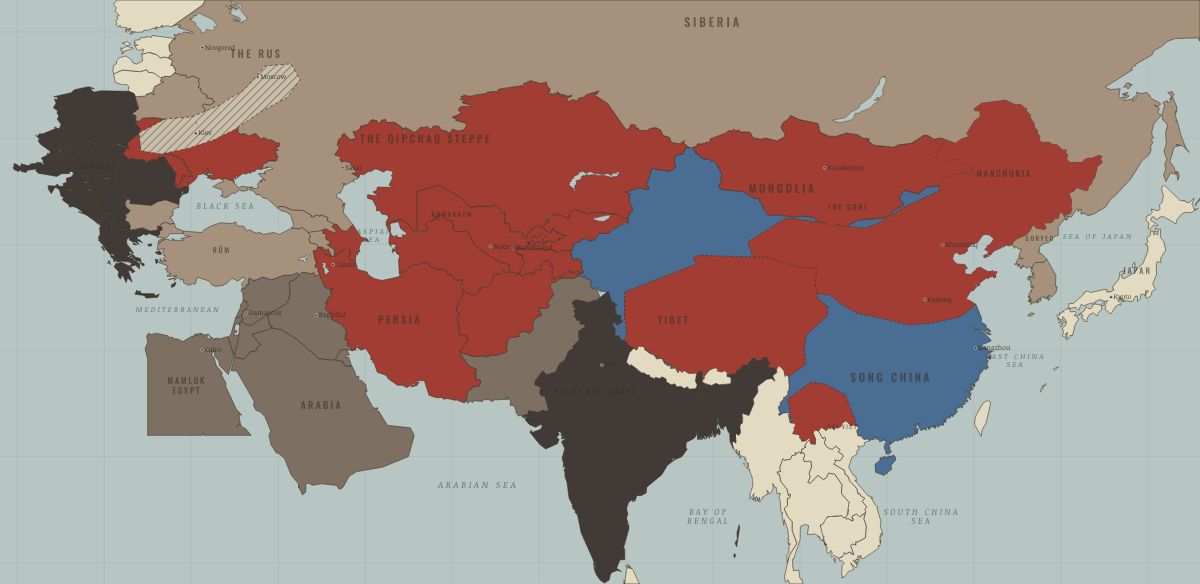
Map of the Mongol Empire in 1254
The empire of Möngke
The Mongol Empire in 1254: The empire of Möngke. Since 1242, 3 territories changed status on this map: Goryeo (mod. North Korea), Goryeo (mod. South Korea) and Arran & Shirvan (mod. Azerbaijan).
1254 · THE MONGOL EMPIRE, 1206–1294 These maps are reconstructed from published sources · Cliopatria v0.2.1 — historical political boundaries · Asia for Educators — Expansion under Ögödei · Asia for Educators — Collapse of the Empire and Four Sectors · ISEAS Nalanda-Sriwijaya Centre Working Paper 25 — Mongol campaigns · Natural Earth — physical reference geography · Janet Martin — Medieval Russia 980–1584, chronology · Institute of History of Ukraine — Mongol invasion and its consequences
Source details Cliopatria contributors / Seshat Global History Databank. CC BY 4.0 · Selected dated polygons; documented unions, differences and shared edges for event-specific reconstructions; projected for display. Asia for Educators, Columbia University. Text consulted for historical facts; no map or prose copied Asia for Educators, Columbia University. Text consulted for historical facts; no map or prose copied ISEAS–Yusof Ishak Institute. Historical facts consulted; no map or prose copied Natural Earth. Public domain Janet Martin, Cambridge University Press. Historical facts consulted; no map or prose copied Encyclopedia of the History of Ukraine, 2019. Historical facts consulted; thematic geometry independently reconstructed proxy: 1206 reference extent · reconstruction: 1188–1259 · reconstruction: 1236–1259 · reconstruction: 1237–1240 · reconstruction: 1250–1259 · reconstruction: 1250–1259 territory; post-1253 allegiance · reconstruction: 1250–1271 · reconstruction: 1250–1278 · reconstruction: 1250–1284 · reconstruction: 1254 · reconstruction: 1254; pre-conquest Tibetan reference 1139–1235 · reconstruction: 1254; regional outlines from pre-conquest 1206 principalities · vector: 1072–1325 · vector: 1072–1374 · vector: 1111–1278 · vector: 1139–1259 · vector: 1188–1259 · vector: 1188–1271 · vector: 1188–1284 · vector: 1188–1304 · vector: 1192–1325 · vector: 1192–1362 · vector: 1202–1259 · vector: 1202–1374 · vector: 1202–1743 · vector: 1210–1304 · vector: 1220–1313 · vector: 1227–1259 · vector: 1236–1259 · vector: 1236–1293 · vector: 1236–1452 · vector: 1241–1271 · vector: 1241–1278 · vector: 1241–1293 · vector: 1241–1313 · vector: 1241–1351 · vector: 1250–1259 · vector: 1250–1271 · vector: 1250–1278 · vector: 1250–1284 · vector: 1250–1293 · vector: 602–1501 · vector: 936–1271
Layer records and reconstruction methods
What changes on the map
On the ground In 1253, Khubilai took the Dali kingdom in Yunnan by a flanking march. The Sakya priest–patron pact of 1247 places Tibet under Mongol overlordship. The chapters of this moment
Related maps
◧ EMBED THIS MAP ON YOUR SITE
You may embed this map free if you keep the attribution link. Teachers can find print-ready
study guides at /study/ .
THE FREE PRINTABLE STUDY GUIDE
Get the printable study guide for The Mongol Empire free. I’ll send you a few short letters, then one when a new atlas opens. That’s all. — Paul
NO TRACKING · YOUR ADDRESS IS USED FOR THE DISPATCH AND NOTHING ELSE ·
UNSUBSCRIBE ANYTIME