MAPS OF HISTORY · WWI · MAPS BY YEAR · December 1912The Great War, 1871–1923 · THE MAP IN DEC 1912
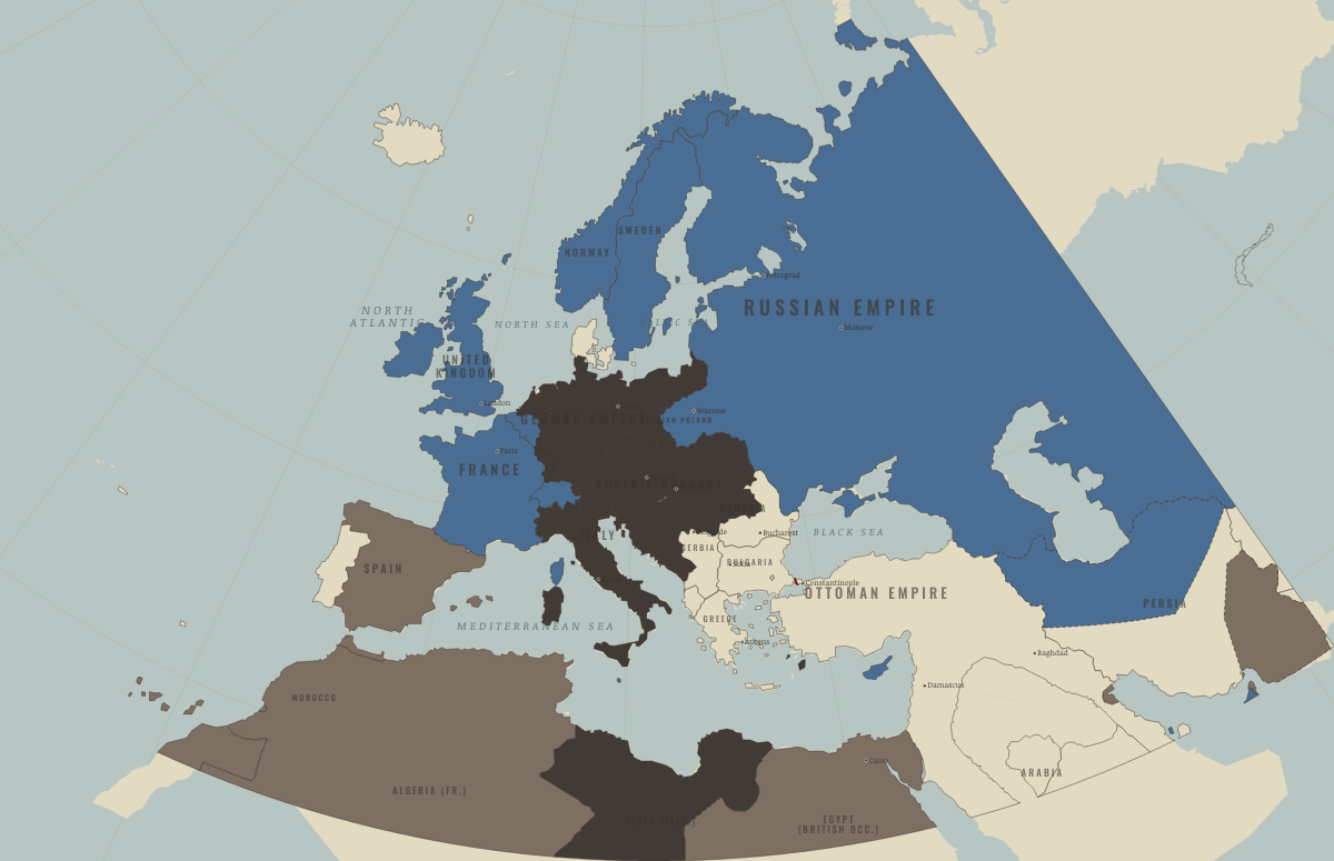
Map of Europe in December 1912
The First Balkan War · before WWI
Europe in December 1912: The First Balkan War. Since October 1908, 2 territories changed status on this map: Morocco and Libya.
DEC 1912 · THE GREAT WAR, 1871–1923 These maps are reconstructed from published sources · Balkan Wars 1912–1913, International Encyclopedia of the First World War · Cliopatria v 0.2.1 · Natural Earth physical geography · Anglo-Russian Convention, 31 August 1907, articles I–II · Maps of History: Great War geographic decisions · US Military Academy World War I atlas, chart 2
Source details Richard C. Hall; November 1912 Chataldzha defensive line and December armistice.. Historical geographic evidence, independent reconstruction Cliopatria contributors / Seshat Global History Databank. Source polygons retained with original identities; geographic selections and corrections by Maps of History.. CC BY 4.0 Made with Natural Earth; geographic reference and physical land only. No modern political boundary is used as a historical boundary.. Public domain US Department of State, Foreign Relations of the United States; convention’s named places define the two concession spheres.. Historical treaty facts, independently reconstructed Maps of History. Campaign-sector connectors and contextual regions are identified separately from imported vector outlines.. Original geographic reconstruction using attributed historical evidence US Military Academy, Department of History & War Studies, World War I chart 2. Selected geographic front facts reconstructed independently; no claim of blanket public-domain artwork rights.. Geographic evidence citation; source index requests permission for map reprints. Original artwork is not redistributed. Annual source features can describe claims, legal territory or military control. Occupied extensions are separated from the prewar Central Power homelands, while the original source names and shapes remain available.
reconstruction: 1871–1918 · reconstruction: 31 August 1907 · reconstruction: November 1912 Chatalja geographic reference · vector: 1815–1937 · vector: 1848–1935 · vector: 1864–1921 · vector: 1871–1914 · vector: 1871–1916 · vector: 1873–1914 · vector: 1890–1914 · vector: 1895–1917 · vector: 1898–1914 · vector: 1900–1912 · vector: 1900–1918 · vector: 1905–1912 · vector: 1905–1914 · vector: 1905–1915 · vector: 1905–1921 · vector: 1908–1935 · vector: 1911–1912 · vector: 1911–1913 · vector: 1912–1912 · vector: 1912–1913 · vector: 1912–1914 · vector: 1912–1915 · vector: 1912–1919 · vector: 1912–1921 · vector: 1912–1955
Layer records and reconstruction methods
What changes on the map Morocco — → Entente-aligned & imperial territories Libya — → Germany and its allies — the Central Powers
Related maps
◧ EMBED THIS MAP ON YOUR SITE
You may embed this map free if you keep the attribution link. Teachers can find print-ready
study guides at /study/ .
THE FREE PRINTABLE STUDY GUIDE
Get the printable study guide for WWI free. I’ll send you a few short letters, then one when a new atlas opens. That’s all. — Paul
NO TRACKING · YOUR ADDRESS IS USED FOR THE DISPATCH AND NOTHING ELSE ·
UNSUBSCRIBE ANYTIME