MAPS OF HISTORY · NORSE AND AZTECS · BATTLES AND EVENTS · Nezahualcoyotl’s dikeNorse and Aztecs · TURNING POINT · c. 1449
Nezahualcoyotl’s dike (c. 1449)
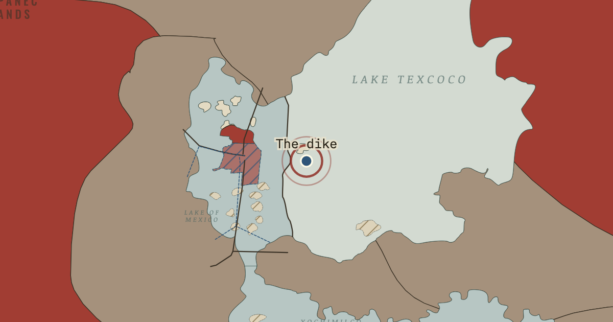
c. 1449 — At Moctezuma I’s request, Nezahualcoyotl directed the building of a barrier about 16 kilometres long, from Atzacoalco to Iztapalapa. Stone and clay were held between rows of stakes. The dike kept floods and the salty eastern lake away from Tenochtitlan, making the western lagoon fresher.
When c. 1449 Type Turning point Chapter Aztec dikes, aqueducts and floods (chapter 8 of Norse and Aztecs)Atlas Climate and Innovation: The Norse and the Aztecs, c. 790–1521 TURNING POINT · CLIMATE AND INNOVATION: THE NORSE AND THE AZTECS, C. 790–1521 These maps are reconstructed from published sources · Natural Earth administrative references · García Quintana and Romero Galván: Tenochtitlan waterworks · Basin of Mexico, c.1519 — published lake and causeway map · Hanns Prem: Tenochtitlan and islands in Texcoco Lake, 2008 · Mexico Secretariat of Culture / INAH: Tlatelolco archaeological-site location · Cliopatria v0.2.1 historical polities · GeoNames geographic controls · Natural Earth v5.1.2 full geographic reference · Aztec tribute provinces, 1519 — published vector map · Rio Verde Archaeology: independent Tututepec
Source details Natural Earth contributors. Public domain García Quintana and Romero Galván: Tenochtitlan waterworks. Historical facts cited; no source artwork or prose reproduced Yavidaxiu, Historicair, Sémhur and named Commons contributors. CC BY-SA 4.0 · Registered source paths and island holes. The two coarsely drawn city holes are superseded by the locally registered Prem city plan; all other shorelines remain. Farm-islet groupings and lake subdivisions are documented derivatives, shared under CC BY-SA 4.0. Hanns Prem. Public domain dedication by the author (PD-self), worldwide reuse for any purpose · Observed city-shoreline and named causeway pixels registered locally to temple/Tacuba/Chapultepec references. No area rescaling. Pixel observations, controls, matrix and review are published. Mexico Secretariat of Culture / INAH: Tlatelolco archaeological-site location. Historical facts cited; no source artwork or prose reproduced Cliopatria contributors / Seshat Global History Databank. CC BY 4.0 GeoNames contributors. CC BY 4.0 Natural Earth contributors. Public domain Yavidaxiu, Ssolbergj, Keepscases and Sémhur. CC BY-SA 3.0 · Registered original province edges; grouped into teaching regions. Published derivative geography and processing records available with attribution. Rio Verde Archaeology: independent Tututepec. Historical facts cited; no source artwork or prose reproduced These maps are reconstructed from published sources. The layer record provides the source geometry, registration controls, reference dates and derivatives.
Lake shores and tribute-region edges are registered from two published 1519 maps. The detailed Prem city plan supplies the central island and its five connecting routes. Where a better downloadable map was unavailable, earlier chapters deliberately reuse these later-source geographic references.
The lake-map control RMS is 2.67 km, and the regional province-map control RMS is 14.79 km. The separate local city fit has a 61 m control RMS and a 330 m leave-one-out RMS. These figures diagnose the control fits; they do not prove the exact position of ancient shorelines. Region grouping, strategic-site margins and independent-state substitutions are documented.
Chinampa layers identify islets mapped by the source in the named agricultural districts. Their filled areas are not a cadastral inventory of every field.
Chapter date: 1499.5. The actual source/reference date is recorded separately for each layer.
proxy: Lower Río Verde / coastal Oaxaca geographic reference · proxy: Published geographic reference; not a medieval administrative survey · reconstruction: 1499 flood; conquest-era city reference · reconstruction: c.1519 named strategic locality · reconstruction: c.1519 source map / named waterwork route · trace: Conquest-era city reference; Prem plan published 2008 · trace: Conquest-era named route; Prem plan published 2008 · trace: c.1519 published reconstruction · trace: c.1519 source map / named waterwork route · vector: 1497–1520
Layer records and reconstruction methods
In the same chapter
Related
THE FREE PRINTABLE STUDY GUIDE
Get the printable study guide for Climate and Innovation free. I’ll send you a few short letters, then one when a new atlas opens. That’s all. — Paul
NO TRACKING · YOUR ADDRESS IS USED FOR THE DISPATCH AND NOTHING ELSE ·
UNSUBSCRIBE ANYTIME