MAPS OF HISTORY · ON THIS DAY · JANUARY 17 · Red Army enters Warsaw (1945)ON THIS DAY · 17 JANUARY 1945
Red Army enters Warsaw
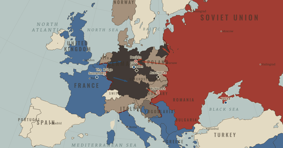
The Red Army enters Warsaw — or what remains of it after the crushed uprising. Perhaps nine in ten buildings are rubble.
17 JANUARY 1945 · THE WAR ROOM — WW2, 1936–1945 These maps are reconstructed from published sources · US War Department — Atlas of the World Battle Fronts (1945) · Cliopatria v0.2.1 — dated political boundaries · Regional history institute — Italian annexations of1941, Fiume province and Krk · Regional history institute — Adriatic occupation chronology,1943–1945 · Regional history institute — Zara evacuation and Yugoslav entry,October1944 · IGM Fiume, 1:25,000, sheet53B II SE — boundary established in1924 · Miroslav Krleža Lexicographic Institute — Lastovo wartime chronology · Natural Earth — physical reference geography · Yugoslavia (1929–1939) location map — international frontier and Adriatic coast · Treaty of Rome (1924), division of Fiume and west-bank boundary · Murli / rowanwindwhistler — Slovakia border changes, 1938–1945 · United States Holocaust Memorial Museum — The Holocaust in Slovakia · Slovak Nation’s Memory Institute — The First Vienna Award
Source details United States War Department, General Staff,1945. US Army official work; public domain Cliopatria contributors / Seshat Global History Databank. CC BY4.0 · Dated polity and constituent territory selections; campaign-dependent occupation overlays reconstructed separately. Regional history institute — Italian annexations of1941, Fiume province and Krk. Historical geographic facts consulted; source prose and artwork not republished Regional history institute — Adriatic occupation chronology,1943–1945. Historical geographic facts consulted; source prose and artwork not republished Regional history institute — Zara evacuation and Yugoslav entry,October1944. Historical geographic facts consulted; source prose and artwork not republished Istituto Geografico Militare, Fiume (printed1946; 1927 survey with1931–1940 updates), reproduced by Istituto regionale per la storia della Resistenza e dell’Età contemporanea nel Friuli Venezia Giulia. Independent reconstruction from graticule coordinates and boundary observations; archive page reserves artwork rights.. Geographical-fact reconstruction; original archive artwork not distributed Miroslav Krleža Lexicographic Institute — Lastovo wartime chronology. Historical geographic facts consulted; source prose and artwork not republished Natural Earth. Public domain NordNordWest/Wikipedia. Converted from the published SVG to WGS84; eastern Italian regional territory extracted. Source cites Velhagen & Klasings Großer Volksatlas (1938).. CC BY-SA 3.0 Germany 1924 agreement interpreted alongside the regional history institute and City of Rijeka’s explanation of the Donja/Gornja Drenova division.. Historical geographic facts; citation only Murli; SVG adaptation by rowanwindwhistler (2021). CC BY-SA 2.5; derived geographic paths under the same license · Georeferenced actual published vector regions using eight printed city positions; no map artwork or labels in the atlas. United States Holocaust Memorial Museum — The Holocaust in Slovakia. Historical chronology consulted; no source prose or artwork republished Slovak Nation’s Memory Institute — The First Vienna Award. Historical territorial chronology consulted; no source artwork or prose republished The eastern campaign front does not extend Soviet control into Greece, Albania, or the Yugoslav Partisan theatre. For January 1945, liberated Greece and Albania use the closest published 1945 national reference. Bypassed island garrisons fall outside its regional precision.
The moving front follows the source-map position for 1945-01-15. The source date is kept separate from the chapter anchor; manual registration has the precision of a regional map.
The legacy Italian front ID is retained, while its geometry follows the actual dated front. In June 1944 the front is near Rome, rather than prematurely at the Gothic Line.
Slovak territory is reconstructed from the published 1938–1945 border-change map, which separates the client state from Hungarian and German annexations. This regional source does not resolve small northern frontier changes or survey-level detail. After August 1944, German military occupation supersedes the client-state fill.
Published prewar regional land geometry supplies a geographic reference for military control documented separately. Lastovo is Partisan-held after September 1943; Zara changes after October 1944. These regional fills do not claim continuous control of every rural locality.
The dates of published political outlines retain the resolution available in their sources. Military fronts and operational perimeters have their own source and method records.
reconstruction: 1942–1945 · reconstruction: 1943–1944 · reconstruction: 1943–1945 · reconstruction: 1944–1944 · reconstruction: 1945-01-15 · reconstruction: 1945.06 · reconstruction: January 1945; 1945 national reference · trace: 1945-01-15 · vector: 1912–1955 · vector: 1936–1944 · vector: 1936–1945 · vector: 1938–1972 · vector: 1939–1944 · vector: 1939–2023 · vector: 1941–1944 · vector: 1943–1944 · vector: 1944–1944 · vector: 1944–1945
Layer records and reconstruction methods
The moment in context The Ardennes offensive was meant to change the political situation as well as the military one. In December 1944 Hitler sent his forces west in the hope of splitting the British and American armies and taking Antwerp. If the blow produced a rupture among the Allies, Germany might escape defeat. Surprise helped the attack at first, but the distance to Antwerp required fuel, transport, and reserves Germany did not have. Within weeks the offensive had failed, and the forces spent on it were unavailable for the defense of Germany.
From End of WW2 in Europe , chapter 13 of The War Room — WW2, 1936–1945 (FEB 1945).
Teach this in 5 minutes Why it happened — Unconditional surrender and terror. The Allies announced their demand for unconditional surrender at Casablanca in 1943. For Nazi leaders implicated in immense crimes, a negotiated…The turn — Berlin, 16 April–2 May. Stalin sent two marshals racing one another toward Berlin between 16 April and 2 May. Some 2.5 million Soviet troops faced a garrison including…What it changed — Evidence and postwar law. Liberation brought the evidence of Nazi crimes to a wider public. The postwar response drew on new legal and moral language: “genocide” was coined…Then ask the room: Could the Western Allies have reached Berlin first, and should they have tried? The argued answer is on the chapter page →
The atlas that shows it
THE FREE PRINTABLE STUDY GUIDE
Get the printable study guide for WW2 free. I’ll send you a few short letters, then one when a new atlas opens. That’s all. — Paul
NO TRACKING · YOUR ADDRESS IS USED FOR THE DISPATCH AND NOTHING ELSE ·
UNSUBSCRIBE ANYTIME