MAPS OF HISTORY · WW2 · ALL CHAPTERS · CHAPTER 11
CHAPTER 11 · AUG 1942–OCT 1944 · NOV 1943
The Island Road
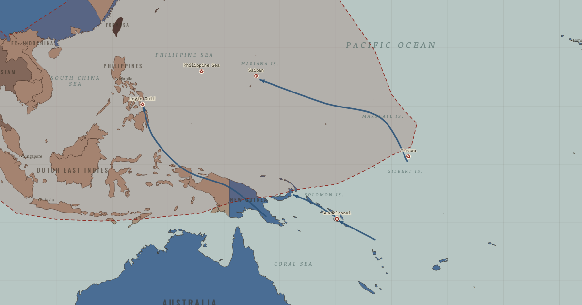
The map above is the world of FEB 1943 — The tide checks.
BRIEF EXPLANATION — THE ESSENTIAL ARGUMENT
The Allied road back across the Pacific was won by logistics and by choosing which battles not to fight. The counteroffensive began at Guadalcanal in 1942 and then split into two converging routes, as General MacArthur advanced through New Guinea toward the Philippines while Admiral Nimitz drove across the Central Pacific. Rather than storm every strong Japanese base in their path, the Allies isolated the most powerful ones, such as the great garrison at Rabaul, and left them to wither behind the front.
This method of skipping past strongholds is called leapfrogging. The islands that were taken supplied airfields and anchorages for the next jump, while the garrisons that were bypassed lost their supply and their strategic value. Beneath these campaigns, American submarines sank much of Japan’s merchant fleet, cutting the island empire off from the very resources it had gone to war to seize. By the Battle of Leyte Gulf in October 1944, Japan’s navy had been broken as an offensive force, and its scattered perimeter had become a chain of isolated garrisons.
GUIDED EXPLANATION
Guadalcanal was the first sustained Allied ground offensive of the Pacific war, and its lessons shaped everything that followed. Six months of grinding fighting on land, at sea, and in the air exhausted both sides, while tropical disease inflicted enormous losses of its own. Japan finally evacuated the island in February 1943. The result proved two things at once, that the Japanese perimeter could be pushed back, and that assaulting every defended island in turn would be far too costly to sustain across the whole ocean.
Allied planners answered that problem with leapfrogging, capturing only the positions needed for aircraft, ships, and supply, and then isolating the rest. The huge garrison at Rabaul was left in place but could no longer influence the campaign. Two routes ran across the map, as MacArthur pushed along the New Guinea coast toward the Philippines while Nimitz advanced through the Central Pacific toward the Marianas. The rivalry between them wasted some effort, yet it also forced Japan to defend against several possible lines of attack. Beneath both offensives, American submarines severed the merchant shipping that connected Japan to its conquered resources, and at Leyte Gulf in October 1944 much of Japan’s remaining fleet was destroyed as an effective offensive force.
The hidden engine of the whole advance was logistics. Tankers, repair ships, engineers, airfields, and protected convoys allowed the United States to project combat power across immense distances, whereas Japan could fortify individual islands but could neither supply them all nor guess which would be attacked next. Bypassing a fortress was therefore selective rather than automatic. Some islands had to be taken because their position brought the next objective within range of aircraft, while others could simply be neutralized from the air, and the choice always weighed casualties now against operational value later. By the time the Allies reached the Marianas, B-29 bombers could strike Japan itself, and by the Philippines they were cutting the last southern resource routes, so the Japanese perimeter had ceased to be a functioning empire and had become a set of disconnected outposts.
DEEP EXPLANATION — EVIDENCE & INTERPRETATION
Logistics made the ocean crossable
Every advance across the Pacific depended on a chain of fuel, repair, construction, food, medical care, and shipping, and that chain, more than any battle, decided the campaign. The United States built mobile bases, fleet oilers, floating dry docks, and Seabee construction units that turned selected islands into airfields and anchorages, which meant fleets no longer had to return to distant fixed bases. Japan lacked the merchant ships, escorts, and repair capacity to build anything comparable, and American submarines exploited that weakness by sinking more than half of the Japanese merchant marine. The whole purpose of Japanese expansion had been to secure resources, yet shipping losses stopped those resources from reaching industry and the front. This exposes a central strategic paradox, because territory without transport produced no usable power. The shrinking perimeter on the map should therefore be read together with the invisible sea lanes, since control counted for little once food, fuel, aircraft, and replacements could no longer move.
Choosing what not to attack
Bypassing a fortress was never a passive act. Allied air and naval forces first had to isolate it, suppress its aircraft, and cut off its resupply, after which a stranded garrison could consume Japanese resources without threatening the advance, whereas storming it would have cost heavy casualties for little strategic gain. The method aimed at the enemy’s system rather than at every defended point, and it carried a human cost, because bypassed Japanese troops and the civilians near them suffered hunger, disease, and isolation. Where geography made a position unavoidable, as at Tarawa, Saipan, Iwo Jima, and Okinawa, the assaults were terrible, which shows that leapfrogging was selective rather than universal. Commanders weighed airfield range, anchorage, political commitments, and expected losses in each case, and MacArthur’s return to the Philippines, for example, rested on political as well as strategic reasons, even though alternatives were seriously debated.
The WW2 atlas is free in full — no sign-up.
THE SITES
ON THIS DAY
WHY IT HAPPENED
The tyranny of distance. The Pacific is a logistics war wearing a combat costume. Every arrow on this map is really a chain of tankers, floating dry docks and Seabee airfield battalions; the US built a mobile fleet base system that made the ocean itself passable. Japan never solved the same problem — its garrisons starved at the end of unguarded sea lanes.
Two commanders, two roads. Inter-service rivalry produced parallel offensives (Army/MacArthur in the southwest, Navy/Nimitz in the center). Wasteful in theory, in practice it whipsawed Japanese defenses, which could never guess the next target — an accidental strategy of dilemma.
Unrestricted submarine warfare. The quiet campaign: US subs sank over half of Japan’s merchant marine. An island empire that imported everything now imported almost nothing. By 1945 the blockade alone was defeating Japan — remember that when weighing how the war ended.
THE TURN
Guadalcanal, August 1942–February 1943. The first Allied ground offensive of the Pacific war becomes a meat-grinder both navies feed for six months. Japan finally evacuates — its first territorial loss. The lesson both sides learn: Japan’s soldiers will fight to the death, and America’s production will replace any loss. Both lessons will govern everything to 1945.
WHAT IT CHANGED
The perimeter becomes a prison. Watch the red line on the map shrink from snapshot to snapshot. Each lost anchor (Gilberts → Marshalls → Marianas) exposes the next; bypassed garrisons — hundreds of thousands of men — spend the war growing vegetables and waiting for ships that never come.
Saipan brings the fire home. The Marianas (June 1944) put B-29 bombers in range of Tokyo, and their loss topples General Tojo’s government. The endgame chapter opens from these islands.
India holds, Burma turns. At Imphal and Kohima (spring 1944) Japan’s invasion of India is annihilated — its largest land defeat ever, largely at the hands of Indian divisions. The myth that Asia would welcome Japan as liberator dies in the Naga hills.
FIELD QUESTION — Why bypass a 100,000-man fortress like Rabaul instead of capturing it?
Isolation removed Rabaul’s ability to affect the campaign without paying the likely cost of assault. Air and sea control cut supply, movement, and communication. The objective was not possession of every island but destruction of Japan’s operational network. The comparison with Stalingrad is structural: attack the supporting system around a strongpoint.
AN INTERESTING FACT
Among the Solomons’ thousand small actions: on 2 August 1943 a Japanese destroyer ran down the torpedo boat PT-109, and its 26-year-old skipper towed a burned crewman toward an islet by a life-jacket strap clenched in his teeth. Two Solomon Islander scouts working with the Allied coastwatchers, Biuku Gasa and Eroni Kumana, found the survivors and paddled a rescue message — carved into a coconut husk — through Japanese-held waters. The skipper was John F. Kennedy; the coconut sat on his desk in the Oval Office, and is displayed at his presidential library today.
THE DISPATCH
One short letter when a new atlas opens — and the printable study guide for WW2 is yours now, free.
NO TRACKING · YOUR ADDRESS IS USED FOR THE DISPATCH AND NOTHING ELSE · UNSUBSCRIBE ANYTIME