MAPS OF HISTORY · STALIN’S SOVIET UNION · MAPS BY YEAR · November 1956The Soviet Union under Stalin, 1924–1953 · THE MAP IN NOV 1956
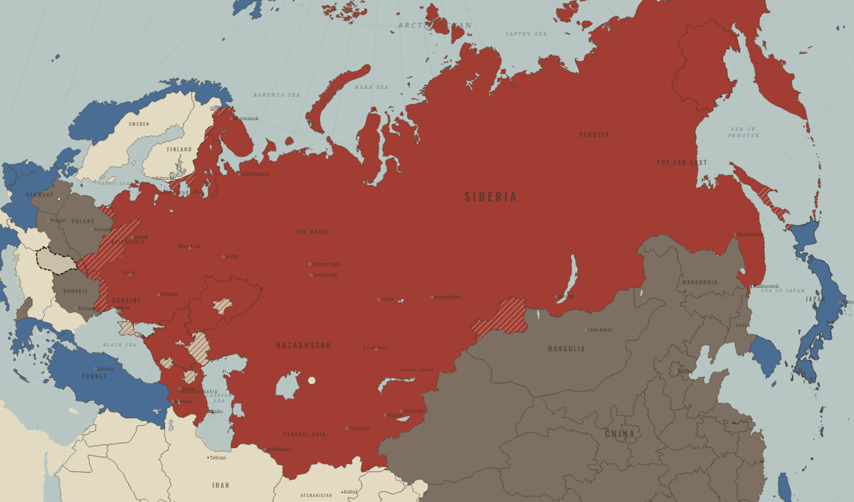
Map of the Soviet Union in November 1956
Hungary crushed · Stalin era
The Soviet Union in November 1956: Hungary crushed. The map shows who held what: The Soviet Union, Rivals & the Western bloc, Satellites & communist allies.
NOV 1956 · THE SOVIET UNION UNDER STALIN, 1924–1953 These maps are reconstructed from published sources · Cliopatria v0.2.1 historical political boundaries · Natural Earth v5.1.2 country geography · Natural Earth full administrative reference geometry · Published projection for the Soviet Union location-map family · Bukharan PSR in the Soviet Union (1922), published vector locator · Volga German ASSR, 20 July 1930: published locator map · The Berlin Airlift, 1948–1949 · Berlin’s four-power status and its termination · The rise and fall of the Berlin Wall · Cliopatria v0.2.1 historical polities · Decolonization of Asia and Africa, 1945–1960 · Natural Earth v5.1.2 country geography · Natural Earth administrative references · Cliopatria v0.2.1 — dated political boundaries · Natural Earth — physical reference geography · Natural Earth 10m — provincial study-region reference · Natural Earth 10m island components; FRUS 1955 evacuation chronology · Cliopatria v 0.2.1 — dated political boundaries
Source details Cliopatria contributors / Seshat Global History Databank. CC BY 4.0 · Dated source selection, component unions, disjoint display masks and source-relative border differences. Natural Earth contributors. Public domain Natural Earth contributors. Public domain · Complete selected units and holes; geographic references to named memorial regions, not claims of dated district perimeters. Hellerick. Mathematical projection parameters; source artwork CC BY-SA 3.0 TRAJAN 117, TarzanASG, Anonimu and Milenioscuro; underlying location-map geography by Hellerick/Natural Earth. CC BY-SA 3.0 · Identified Bukhara, Khorezm and historical Aral SVG paths independently inverse-projected; derivative geometry distributed under CC BY-SA 3.0. Fotisgrek. CC BY-SA 4.0 · Native red territorial class extracted and registered to published lake geography; derivative under CC BY-SA 4.0. US government historical publication. Historical facts cited; no source artwork or prose reproduced US government historical publication. Historical facts cited; no source artwork or prose reproduced US government historical publication. Historical facts cited; no source artwork or prose reproduced Cliopatria contributors / Seshat Global History Databank. CC BY 4.0 · Selected dated records; documented component selection, unions and shared-edge extraction. US Department of State, Office of the Historian. US government publication Natural Earth contributors. Public domain · Full source components and holes retained; documented historical unions and repairs. Natural Earth contributors. Public domain Cliopatria contributors / Seshat Global History Databank. CC BY4.0 · Dated polity and constituent territory selections; campaign-dependent occupation overlays reconstructed separately. Natural Earth. Public domain Natural Earth 10m — provincial study-region reference. Public domain Natural Earth 10m island components; FRUS 1955 evacuation chronology. Natural Earth public domain; historical facts consulted Cliopatria contributors / Seshat Global History Databank. CC BY4.0 · Dated polity and constituent territory selections; campaign-dependent occupation overlays reconstructed separately. proxy: 1945–1990, later municipal exterior reference · proxy: 1956.25 · proxy: 1956.85 · proxy: Natural Earth v5.1.2 · reconstruction: 1936–1937 · reconstruction: 1939/1945 · reconstruction: 1940 · reconstruction: 1940/1945 · reconstruction: 1944 settlement · reconstruction: 1950–1957 · reconstruction: 1953–1972 · reconstruction: 1956.25 · reconstruction: 1956.85 · vector: 1890–2023 · vector: 1922 published political reference; pre-shrink Aral outline · vector: 1945–2023 · vector: 1946–1972 · vector: 1947–1975 · vector: 1948–1962 · vector: 1948–1968 · vector: 1948–1986 · vector: 1949–1962 · vector: 1949–1966 · vector: 1949–1989 · vector: 1949–1990 · vector: 1949–2005 · vector: 1950–1957 · vector: 1950–2023 · vector: 1953–1968 · vector: 1953–2023 · vector: 1956–1957
Layer records and reconstruction methods
Related maps
◧ EMBED THIS MAP ON YOUR SITE
You may embed this map free if you keep the attribution link. Teachers can find print-ready
study guides at /study/ .
THE FREE PRINTABLE STUDY GUIDE
Get the printable study guide for The Soviet Union under Stalin free. I’ll send you a few short letters, then one when a new atlas opens. That’s all. — Paul
NO TRACKING · YOUR ADDRESS IS USED FOR THE DISPATCH AND NOTHING ELSE ·
UNSUBSCRIBE ANYTIME