MAPS OF HISTORY · ANCIENT ROME · MAPS BY YEAR · 201 BCThe Rise and Fall of Rome, 264 BC – AD 476 · THE MAP IN 201 BC
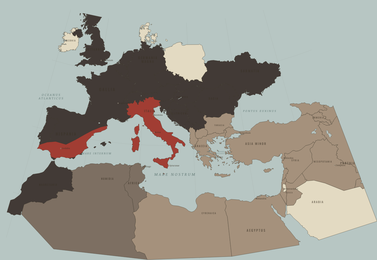
Map of the Roman Republic in 201 BC
After Zama
The Roman Republic in 201 BC: After Zama. Since 216 BC, 3 territories changed status on this map: Hispania (mod. Spain), Africa (mod. Tunisia) and Numidia (mod. Algeria).
201 BC · THE RISE AND FALL OF ROME, 264 BC – AD 476 These maps are reconstructed from published sources · Cliopatria v0.2.1 · The Metropolitan Museum: The Roman Republic · Natural Earth physical coastlines and rivers · Polybius, Histories 1: Sicily and the First Punic War · Polybius, Histories 3: Hannibal’s campaign
Source details Cliopatria contributors / Seshat Global History Databank. Selected, combined, and reprojected by Maps of History; dated adjustments are recorded per layer.. CC BY 4.0 Department of Greek and Roman Art, The Metropolitan Museum of Art (2000).. Historical evidence citation; no prose or map copied Made with Natural Earth. Modern physical geography is a coastline/river reference, not evidence of ancient sovereignty.. Public domain Polybius, Histories, book 1 (Perseus).. Historical evidence citation; no prose or map copied Polybius, Histories, book 3 (Perseus).. Historical evidence citation; no prose or map copied For the post-Zama settlement, the closest settled source outlines, 197 BC, are used in place of the transient campaign polygons.
The reduced Carthaginian treaty-state outline comes from source847, beginning 197 BC.
proxy: 197–145 BC reference for201 BC · proxy: 197–165 BC reference for201 BC · proxy: 197–189 BC reference · proxy: 197–189 BC reference for201 BC · reconstruction: 238 BC onward; modern shoreline reference · reconstruction: Modern physical shoreline reference · vector: -202 to -198 · vector: -203 to -127 · vector: -203 to -171 · vector: -203 to -198 · vector: -206 to -165 · vector: -206 to -198 · vector: -212 to -189 · vector: -212 to -198 · vector: -230 to -171 · vector: -230 to -92 · vector: -239 to -127 · vector: -279 to -145 · vector: -630 to 337
Layer records and reconstruction methods
What changes on the map
On the ground The coast of Hispania contains two Roman provinces, while its interior remains unconquered Related maps
◧ EMBED THIS MAP ON YOUR SITE
You may embed this map free if you keep the attribution link. Teachers can find print-ready
study guides at /study/ .
THE FREE PRINTABLE STUDY GUIDE
Get the printable study guide for Rome free. I’ll send you a few short letters, then one when a new atlas opens. That’s all. — Paul
NO TRACKING · YOUR ADDRESS IS USED FOR THE DISPATCH AND NOTHING ELSE ·
UNSUBSCRIBE ANYTIME