MAPS OF HISTORY · MONGOL EMPIRE · MAPS BY YEAR · September 1260The Mongol Empire, 1206–1294 · THE MAP IN SEP 1260
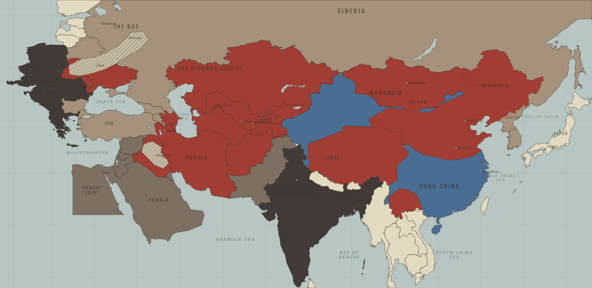
Map of the Mongol Empire in September 1260
Ain Jalut — the first check
The Mongol Empire in September 1260: Ain Jalut — the first check. Since March 1260, 2 territories changed status on this map: Ayyubid Syria and The Levant coast (mod. Lebanon).
SEP 1260 · THE MONGOL EMPIRE, 1206–1294 These maps are reconstructed from published sources · Reuven Amitai-Preiss — Mongols and Mamluks, chapter 2 · Cliopatria v0.2.1 — historical political boundaries · Asia for Educators — Expansion under Ögödei · Asia for Educators — Collapse of the Empire and Four Sectors · ISEAS Nalanda-Sriwijaya Centre Working Paper 25 — Mongol campaigns · Peter Jackson, Encyclopaedia Iranica — Mongols · The Metropolitan Museum of Art — The Legacy of Genghis Khan · Natural Earth — physical reference geography · Janet Martin — Medieval Russia 980–1584, chronology · Institute of History of Ukraine — Mongol invasion and its consequences
Source details Reuven Amitai-Preiss, Cambridge University Press, 1995. Historical facts consulted; no map or prose copied Cliopatria contributors / Seshat Global History Databank. CC BY 4.0 · Selected dated polygons; documented unions, differences and shared edges for event-specific reconstructions; projected for display. Asia for Educators, Columbia University. Text consulted for historical facts; no map or prose copied Asia for Educators, Columbia University. Text consulted for historical facts; no map or prose copied ISEAS–Yusof Ishak Institute. Historical facts consulted; no map or prose copied Peter Jackson / Encyclopaedia Iranica. Historical facts consulted; thematic geometry independently reconstructed Qamar Adamjee and Stefano Carboni, 2003. Historical facts consulted; no image or prose copied Natural Earth. Public domain Janet Martin, Cambridge University Press. Historical facts consulted; no map or prose copied Encyclopedia of the History of Ukraine, 2019. Historical facts consulted; thematic geometry independently reconstructed The annual source shows the March 1260 Syrian invasion throughout 1260–1271. The September withdrawal is reconstructed using only the Syrian gain in the next Mamluk reference.
proxy: 1206 reference extent · proxy: Goryeo 1227–1259 territorial reference · reconstruction: 1237–1240 · reconstruction: 1250–1259 territory; post-1253 allegiance · reconstruction: 1250–1271 · reconstruction: 1250–1278 · reconstruction: 1250–1284 · reconstruction: 1258 · reconstruction: 1260 · reconstruction: 1260; pre-conquest Tibetan reference 1139–1235 · reconstruction: 1260; regional outlines from pre-conquest 1206 principalities · reconstruction: 1260–1271 · reconstruction: 1260–1278 · reconstruction: 1260–1284 · reconstruction: 1260–1313 · reconstruction: September 1260; Syrian boundary reference 1272–1278 · vector: 1072–1325 · vector: 1072–1374 · vector: 1111–1278 · vector: 1188–1271 · vector: 1188–1284 · vector: 1188–1304 · vector: 1192–1325 · vector: 1192–1362 · vector: 1202–1374 · vector: 1202–1743 · vector: 1210–1304 · vector: 1220–1313 · vector: 1236–1293 · vector: 1236–1452 · vector: 1241–1271 · vector: 1241–1278 · vector: 1241–1293 · vector: 1241–1313 · vector: 1241–1351 · vector: 1250–1271 · vector: 1250–1278 · vector: 1250–1284 · vector: 1250–1293 · vector: 1260–1271 · vector: 1260–1278 · vector: 1260–1284 · vector: 1260–1293 · vector: 1260–1313 · vector: 1260–1384 · vector: 1260–1394 · vector: 1260–1439 · vector: 1260–1474 · vector: 602–1501 · vector: 936–1271
Layer records and reconstruction methods
What changes on the map
Related maps
◧ EMBED THIS MAP ON YOUR SITE
You may embed this map free if you keep the attribution link. Teachers can find print-ready
study guides at /study/ .
THE FREE PRINTABLE STUDY GUIDE
Get the printable study guide for The Mongol Empire free. I’ll send you a few short letters, then one when a new atlas opens. That’s all. — Paul
NO TRACKING · YOUR ADDRESS IS USED FOR THE DISPATCH AND NOTHING ELSE ·
UNSUBSCRIBE ANYTIME