MAPS OF HISTORY · INDUSTRIAL REVOLUTION · BATTLES AND EVENTS · Suzhou & the Yangzi deltaIndustrial Revolution · TURNING POINT · c. 1750
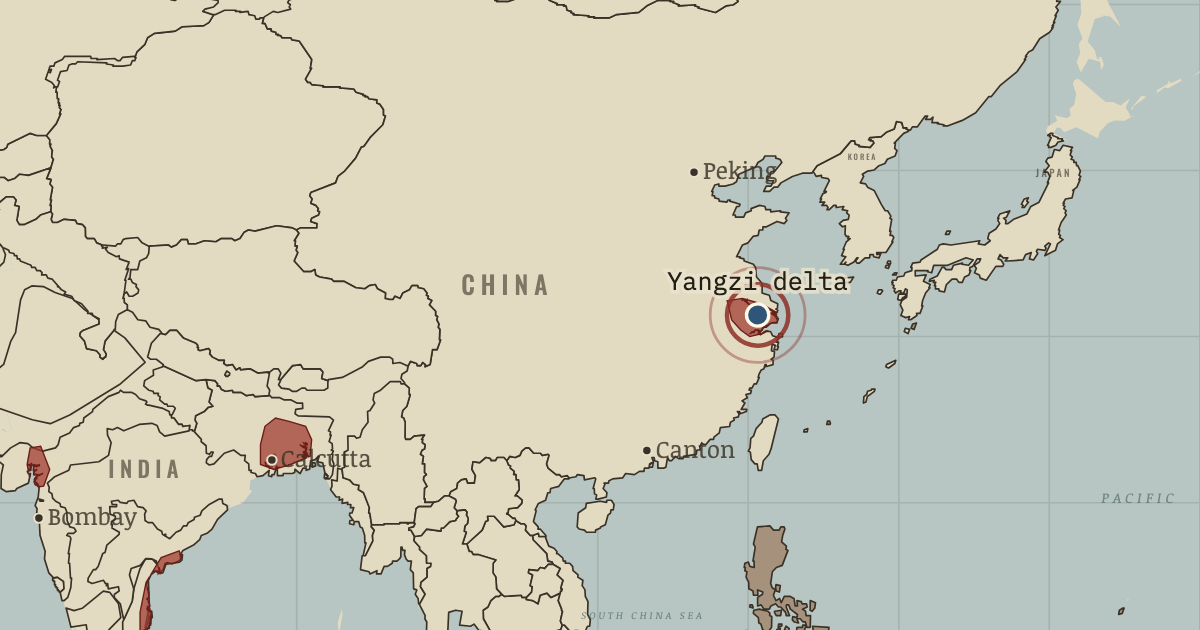
Suzhou & the Yangzi delta (c. 1750)
c. 1750 — Kenneth Pomeranz argues that the Yangzi delta is as commercial and productive as England. Its silk and cotton cloth, canals, markets and high literacy show the strength of its economy. What the region lacks is cheap coal close to its towns and colonies overseas.
When c. 1750 Type Turning point Chapter Why Britain industrialised first (chapter 1 of Industrial Revolution)Atlas The Industrial Revolution, 1750–1914 TURNING POINT · THE INDUSTRIAL REVOLUTION, 1750–1914 These maps are reconstructed from published sources · Bartholomew: Literary & Historical Atlas of America,1911 · Bartholomew: Literary and Historical Atlas of Asia,1912 · Cliopatria v 0.2.1 · University of Oregon: spread of cotton and slavery1790–1860 · Von Steinwehr: distribution of slavery and staple-product districts,1861 · Natural Earth physical geography · Maps of History: industrial geography reconstruction record
Source details John George Bartholomew,1911; economic maps and named transport routes. Original cartographer died1920; independent geographic reconstruction.. Public-domain original historical cartography; geographic facts independently reconstructed John George Bartholomew,1912; economic mapspp40–41,72–73, products54–55; regional railway maps and route gazetteer. Original author died1920. Only geographic facts independently reconstructed; ebook text/brand not republished.. Public-domain original historical cartography; geographic facts independently reconstructed Cliopatria contributors / Seshat Global History Databank. Selected, combined, reprojected and corrected by Maps of History as described per layer.. CC BY4.0 University of Oregon Mapping History: dated direction of expansion. Earlier regional footprints remain educational reconstructions, not county statistics.. Geographic historical facts; original animation/artwork not copied Library of Congress; downloaded four-page historical map includes staple-product inset. Earlier cotton phases are separately sourced.. Historical1861 published map; independent geographic reconstruction Made with Natural Earth; present coastlines support physical clipping, not historical political boundaries.. Public domain Named districts and route stations from the linked published atlases. District perimeters are interpretive economic regions, not sovereign borders or parcel-level industrial land use.. Original independent thematic reconstructions; source artwork not embedded Country fills apply the existing educational industrialisation stages to dated published polities. They do not imply that development was uniform throughout each empire. Economic districts represent thematic regions. Source dates and reconstruction methods are recorded separately.
reconstruction: Named district within chapter chronology · vector: 1429–1771 · vector: 1526–1858 · vector: 1609–1821 · vector: 1612–1848 · vector: 1619–1819 · vector: 1619–1824 · vector: 1619–1829 · vector: 1626–1865 · vector: 1636–1768 · vector: 1636–1804 · vector: 1636–1821 · vector: 1636–1889 · vector: 1640–1859 · vector: 1640–1861 · vector: 1645–1793 · vector: 1670–1751 · vector: 1670–1762 · vector: 1670–1808 · vector: 1670–1821 · vector: 1670–1856 · vector: 1673–1841 · vector: 1677–1806 · vector: 1683–1751 · vector: 1683–1787 · vector: 1683–1793 · vector: 1687–1768 · vector: 1687–1848 · vector: 1691–1799 · vector: 1700–1756 · vector: 1702–1756 · vector: 1706–1787 · vector: 1709–1756 · vector: 1709–1774 · vector: 1709–1787 · vector: 1709–1791 · vector: 1709–1798 · vector: 1709–1855 · vector: 1713–1756 · vector: 1713–1761 · vector: 1713–1768 · vector: 1718–1780 · vector: 1721–1756 · vector: 1721–1774 · vector: 1721–1813 · vector: 1727–1751 · vector: 1727–1771 · vector: 1727–1774 · vector: 1727–1819 · vector: 1727–1899 · vector: 1734–1751 · vector: 1734–1768 · vector: 1734–1771 · vector: 1734–1793 · vector: 1734–1795 · vector: 1734–1841 · vector: 1738–1751 · vector: 1738–1756 · vector: 1738–1768 · vector: 1738–1798 · vector: 1738–1799 · vector: 1741–1751 · vector: 1741–1756 · vector: 1741–1768 · vector: 1741–1771 · vector: 1741–1814 · vector: 1744–1751 · vector: 1744–1756 · vector: 1744–1761 · vector: 1744–1762 · vector: 1744–1774 · vector: 1744–1787 · vector: 1744–1799 · vector: 1744–1827 · vector: 1744–1848 · vector: 1748–1751 · vector: 1748–1756 · vector: 1748–1762 · vector: 1748–1779 · vector: 1748–1791 · vector: 1748–1793 · vector: 1748–1796 · vector: 1750
Layer records and reconstruction methods
In the same chapter
Related
THE FREE PRINTABLE STUDY GUIDE
Get the printable study guide for The Industrial Revolution free. I’ll send you a few short letters, then one when a new atlas opens. That’s all. — Paul
NO TRACKING · YOUR ADDRESS IS USED FOR THE DISPATCH AND NOTHING ELSE ·
UNSUBSCRIBE ANYTIME