MAPS OF HISTORY · INDIAN INDEPENDENCE · MAPS BY YEAR · January 1857Indian Independence & Partition, 1857–1964 · THE MAP IN JAN 1857
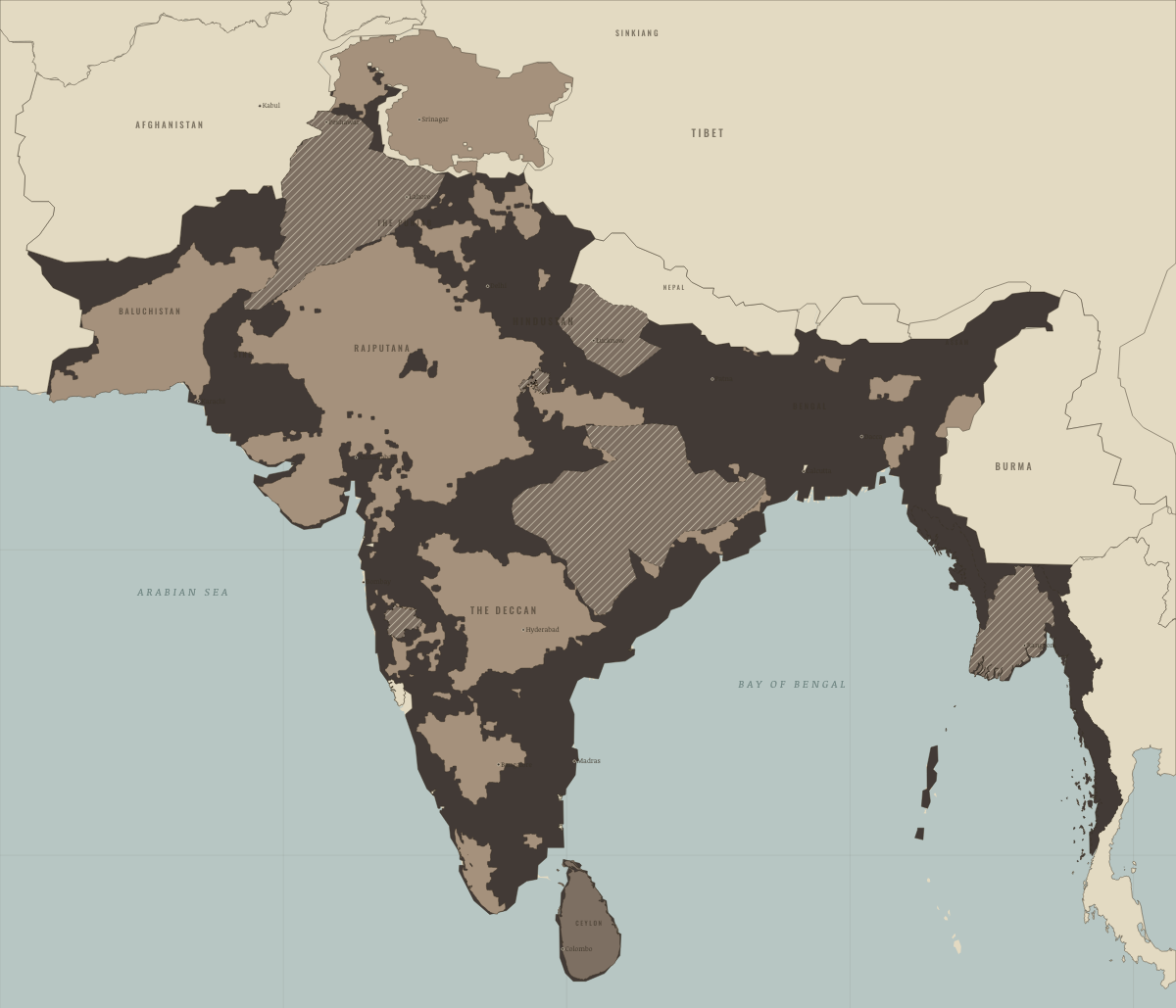
Map of India in January 1857
The Company’s India
India in January 1857: The Company’s India. The map shows who held what: British India — direct rule, Crown colonies · Burma after 1937.
JAN 1857 · INDIAN INDEPENDENCE & PARTITION, 1857–1964 These maps are reconstructed from published sources · Cliopatria v0.2.1: dated historical polity records · geoBoundaries India ADM2 (2021): named district reference geometry · Natural Earth v5.1.2: complete country reference geometry · Natural Earth: administrative reference units · Imperial Gazetteer Atlas (1907): India in 1837 and 1857 · Imperial Gazetteer of India (1908): Indian Empire political plate
Source details Cliopatria contributors / Seshat Global History Databank. CC BY 4.0 · Reviewed record selection; East/West Pakistan selected as complete components; source dates and identities retained. geoBoundaries / Pathways Data Pvt Ltd / lgdirectory.gov.in. ODbL 1.0 · Selected complete named districts dissolved as documented historical reporting-region proxies. Derived database also available in reconstructed-india.geojson under ODbL 1.0. Natural Earth. Public domain Natural Earth. Public domain · Full components retained and dissolved into explicitly dated historical groups; no source-coordinate simplification. Imperial Gazetteer Atlas of India / Edinburgh Geographical Institute. Public domain · Georegistered 1837 Oudh and Bhonsla/Nagpur polity traces provide pre-annexation context; intervening local changes remain a limitation. J. G. Bartholomew / Imperial Gazetteer of India, 1908; scan Fowler & Fowler. Public domain · Native-resolution colour-boundary extraction; printed graticule registration; printed label holes removed, territorial enclaves retained. 1908 geography is explicitly a nearby-date proxy in earlier chapters. Princely-state geography follows the published 1908 plate. Earlier chapters use it explicitly as a nearby-date reference, rather than reconstructing local state transfers as exact dated surveys.
The British administrative backdrop uses the complete 1859 Raj source, the closest reference before or after the rebellion. The 1857–1858 source excludes insurgent-controlled northern India; those gaps must not appear as neutral territory beneath the thematic rebellion locators.
The treaty/paramountcy patchwork provides a political reference. Hatches for famine, violence and rebellion locate affected reporting regions rather than areas of uniform territorial possession.
proxy: 1859–1859 · proxy: 2021 same-named district proxy for the historical region · proxy: Contemporary regional reference · proxy: Historical enclave, source-vintage outline · proxy: Modern same-enclave reference · proxy: Natural Earth v5.1.2 · reconstruction: 1852 annexation region; successor unit boundaries · reconstruction: 1852–1885 grouping; modern regional reference · reconstruction: 1908 printed patchwork with coastal registration · trace: 1837 published polity outline, preceding 1854/1856 annexations · vector: 1842–1889 · vector: 1848 Sikh Empire source · vector: 1853–1858 · vector: 1856–1889 · vector: 1857–1858 · vector: 1857–1872
Layer records and reconstruction methods
On the ground Lower Burma — Britain held Arakan and Tenasserim from 1826 and Pegu from 1852; the inland kingdom of Ava remained free until 1885 Dalhousie’s annexations, 1848–56 — he annexed the Punjab, Pegu, Satara, Jhansi and Nagpur, followed by Oudh in 1856 Dalhousie’s annexations, 1848–56 — he annexed the Punjab, Pegu, Satara, Jhansi and Nagpur, followed by Oudh in 1856 Dalhousie’s annexations, 1848–56 — he annexed the Punjab, Pegu, Satara, Jhansi and Nagpur, followed by Oudh in 1856 Dalhousie’s annexations, 1848–56 — he annexed the Punjab, Pegu, Satara, Jhansi and Nagpur, followed by Oudh in 1856 Dalhousie’s annexations, 1848–56 — he annexed the Punjab, Pegu, Satara, Jhansi and Nagpur, followed by Oudh in 1856 Dalhousie’s annexations, 1848–56 — he annexed the Punjab, Pegu, Satara, Jhansi and Nagpur, followed by Oudh in 1856 The princely state of Jammu & Kashmir had a Hindu maharaja and a Muslim majority The Rajputana Agency contained some twenty princely states, from Jaipur to Jodhpur The Central India Agency included Gwalior, Indore, Bhopal, Rewa and the Bundelkhand states The Western India states included Baroda, the Kathiawar states and Cutch Hyderabad State — the Nizam’s dominion and the largest of the princely states Mysore State — the “model state” within the princely order Travancore & Cochin — princely Kerala Kalat and the Baluchistan states, under the Khan of Kalat Bahawalpur State, along the Sutlej Related maps
◧ EMBED THIS MAP ON YOUR SITE
You may embed this map free if you keep the attribution link. Teachers can find print-ready
study guides at /study/ .
THE FREE PRINTABLE STUDY GUIDE
Get the printable study guide for Indian Independence & Partition free. I’ll send you a few short letters, then one when a new atlas opens. That’s all. — Paul
NO TRACKING · YOUR ADDRESS IS USED FOR THE DISPATCH AND NOTHING ELSE ·
UNSUBSCRIBE ANYTIME