MAPS OF HISTORY · INDIAN INDEPENDENCE · MAPS BY YEAR · 1943Indian Independence & Partition, 1857–1964 · THE MAP IN 1943
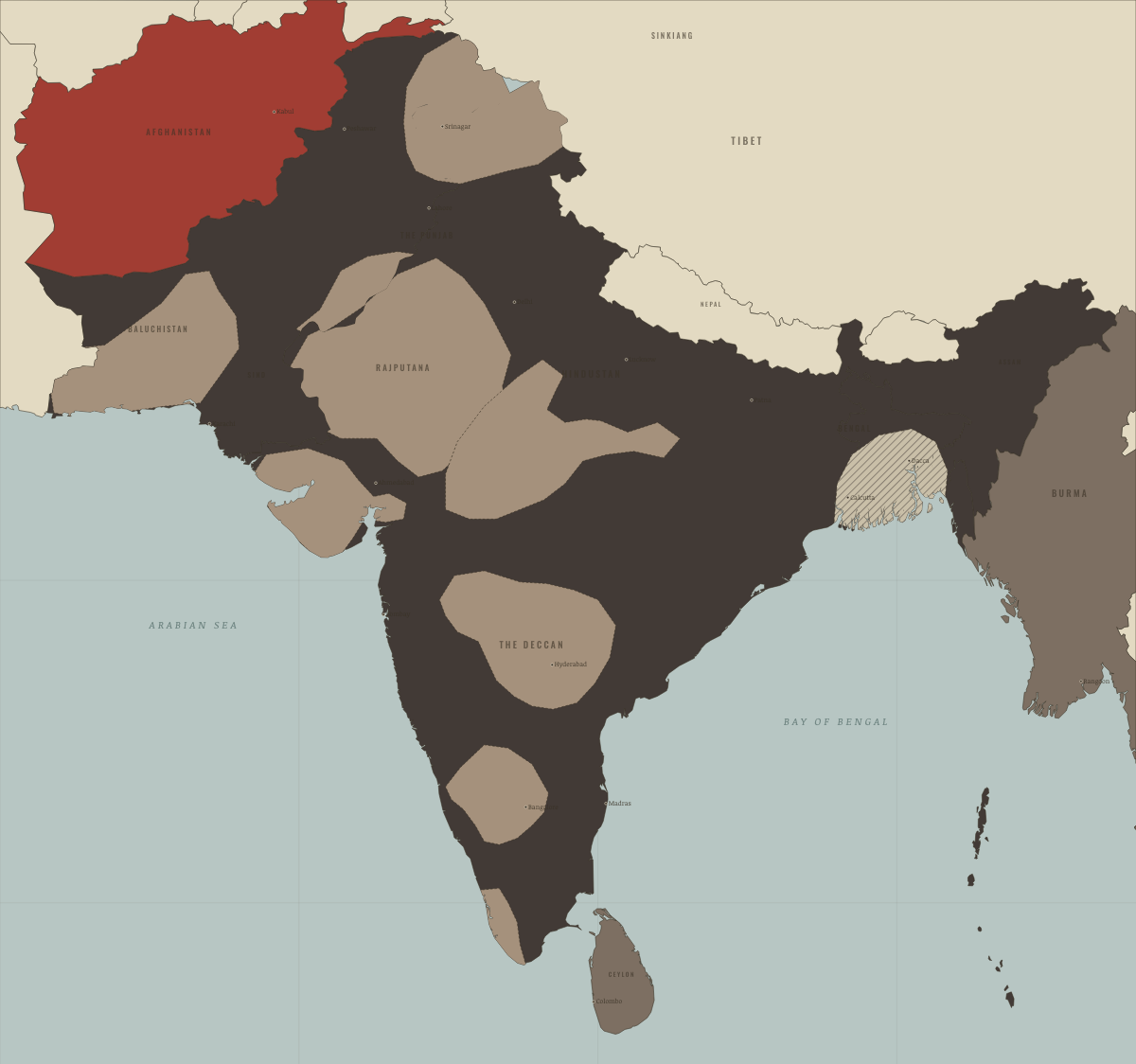
Map of India in 1943
Famine in Bengal
India in 1943: Famine in Bengal. The map shows who held what: British India — direct rule, Crown colonies · Burma after 1937, Self-rule / independent.
1943 · INDIAN INDEPENDENCE & PARTITION, 1857–1964 These maps are reconstructed from published sources · Cliopatria v0.2.1: dated historical polity records · National Archives of India: Abhilekh Patal historical records portal · Natural Earth v5.1.2: complete country reference geometry · Natural Earth: administrative reference units · Imperial Gazetteer of India (1908): Indian Empire political plate
Source details Cliopatria contributors / Seshat Global History Databank. CC BY 4.0 · Reviewed record selection; East/West Pakistan selected as complete components; source dates and identities retained. National Archives of India; contextual historical records, not a boundary survey. Historical factual reference; no source prose reproduced Natural Earth. Public domain Natural Earth. Public domain · Full components retained and dissolved into explicitly dated historical groups; no source-coordinate simplification. J. G. Bartholomew / Imperial Gazetteer of India, 1908; scan Fowler & Fowler. Public domain · Native-resolution colour-boundary extraction; printed graticule registration; printed label holes removed, territorial enclaves retained. 1908 geography is explicitly a nearby-date proxy in earlier chapters. Princely-state geography follows the published 1908 plate. Earlier chapters use it explicitly as a nearby-date reference, rather than reconstructing local state transfers as exact dated surveys.
The treaty/paramountcy patchwork provides a political reference. Hatches for famine, violence and rebellion locate affected reporting regions rather than areas of uniform territorial possession.
proxy: Contemporary regional reference · proxy: Historical enclave, source-vintage outline · proxy: Modern same-enclave reference · proxy: Natural Earth v5.1.2 · reconstruction: 1908 printed patchwork with coastal registration · reconstruction: Event-specific regional reporting units; source-vintage geography · vector: 1890–2023 · vector: 1939–1943 · vector: 1939–1946 · vector: 1942–1945 · vector: 1943–1944 · vector: 1943–1946
Layer records and reconstruction methods
On the ground Bengal’s famine districts, 1943–44 — perhaps 2–3 million people died Related maps
◧ EMBED THIS MAP ON YOUR SITE
You may embed this map free if you keep the attribution link. Teachers can find print-ready
study guides at /study/ .
THE FREE PRINTABLE STUDY GUIDE
Get the printable study guide for Indian Independence & Partition free. I’ll send you a few short letters, then one when a new atlas opens. That’s all. — Paul
NO TRACKING · YOUR ADDRESS IS USED FOR THE DISPATCH AND NOTHING ELSE ·
UNSUBSCRIBE ANYTIME