MAPS OF HISTORY · WWI · BATTLES AND EVENTS · Battle of AmiensWWI · BATTLE SITE · 1918
Battle of Amiens (1918)
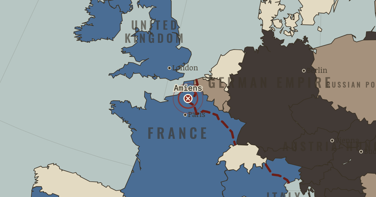
On the WWI map as “Amiens”
8 Aug 1918 — The attack at Amiens brings together 530 tanks, 800 aircraft, artillery dominance and total surprise. Within hours the German line breaks and 15,000 men surrender. Ludendorff calls it “the black day of the German Army”: what troubles him is not the ground lost, but the surrender of the men.
When 8 Aug 1918 Type Battle site Chapter Spring Offensive and Hundred Days (chapter 12 of WWI)Atlas The Great War, 1871–1923 BATTLE SITE · THE GREAT WAR, 1871–1923 These maps are reconstructed from published sources · Cliopatria v 0.2.1 · National Army Museum: Mesopotamia campaign · Natural Earth physical geography · National Army Museum: Ramadi, September 1917 · Maps of History: Great War geographic decisions · National Army Museum: Salonika campaign · US Military Academy World War I atlas, chart 15 · US Military Academy World War I atlas, chart 18 · US Military Academy World War I atlas, chart 39 · US Military Academy World War I atlas, chart 41 · US Military Academy World War I atlas, chart 47 · US Military Academy World War I atlas, chart 49
Source details Cliopatria contributors / Seshat Global History Databank. Source polygons retained with original identities; geographic selections and corrections by Maps of History.. CC BY 4.0 National Army Museum; Basra, Kut, Baghdad and late 1917 campaign positions.. Historical evidence citation, no artwork copied Made with Natural Earth; geographic reference and physical land only. No modern political boundary is used as a historical boundary.. Public domain National Army Museum, accession 1965-10-209-49; Ramadi captured 28–29 September 1917.. Historical evidence citation Maps of History. Campaign-sector connectors and contextual regions are identified separately from imported vector outlines.. Original geographic reconstruction using attributed historical evidence National Army Museum: late 1916 Albanian coast–Monastir–Doiran–Struma line and 1918 liberation campaign.. Historical evidence citation; no artwork copied US Military Academy, Department of History & War Studies, World War I chart 15. Selected geographic front facts reconstructed independently; no claim of blanket public-domain artwork rights.. Geographic evidence citation; source index requests permission for map reprints. Original artwork is not redistributed. US Military Academy, Department of History & War Studies, World War I chart 18. Selected geographic front facts reconstructed independently; no claim of blanket public-domain artwork rights.. Geographic evidence citation; source index requests permission for map reprints. Original artwork is not redistributed. US Military Academy, Department of History & War Studies, World War I chart 39. Selected geographic front facts reconstructed independently; no claim of blanket public-domain artwork rights.. Geographic evidence citation; source index requests permission for map reprints. Original artwork is not redistributed. US Military Academy, Department of History & War Studies, World War I chart 41. Selected geographic front facts reconstructed independently; no claim of blanket public-domain artwork rights.. Geographic evidence citation; source index requests permission for map reprints. Original artwork is not redistributed. US Military Academy, Department of History & War Studies, World War I chart 47. Selected geographic front facts reconstructed independently; no claim of blanket public-domain artwork rights.. Geographic evidence citation; source index requests permission for map reprints. Original artwork is not redistributed. US Military Academy, Department of History & War Studies, World War I chart 49. Selected geographic front facts reconstructed independently; no claim of blanket public-domain artwork rights.. Geographic evidence citation; source index requests permission for map reprints. Original artwork is not redistributed. Annual source features can describe claims, legal territory or military control. Occupied extensions are separated from the prewar Central Power homelands, while the original source names and shapes remain available.
The area east/north of the sourced western front is selected within the 1914 historical French, Belgian and Luxembourg footprints. It represents military control, not annexation.
The displayed state is iss 18 jul. Geographic reference dates and reconstruction methods are recorded for each feature.
reconstruction: 12 November 1917 Piave withdrawal reference · reconstruction: 1871–1918 · reconstruction: 1917 annual control · reconstruction: 1918 limit of occupation after Brest-Litovsk · reconstruction: 1918.52 · reconstruction: 30 December 1917 · reconstruction: 30 December 1917 northern line reference · reconstruction: Late 1916 allied line · reconstruction: Late 1917 campaign-sector reference · reconstruction: Maximum advances through 18 July 1918
Layer records and reconstruction methods
In the same chapter
Related
THE FREE PRINTABLE STUDY GUIDE
Get the printable study guide for WWI free. I’ll send you a few short letters, then one when a new atlas opens. That’s all. — Paul
NO TRACKING · YOUR ADDRESS IS USED FOR THE DISPATCH AND NOTHING ELSE ·
UNSUBSCRIBE ANYTIME