MAPS OF HISTORY · REFUGEE CRISES · MAPS BY YEAR · July 1954Uprooted: Refugees in Europe 1945–1960 and Indochina 1975–1990 · THE MAP IN JUL 1954
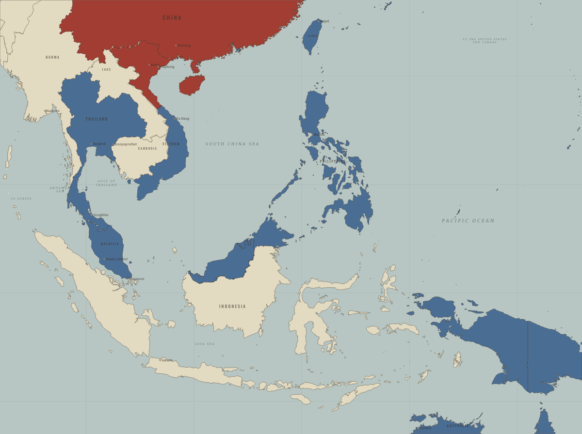
Map of refugees in Southeast Asia in July 1954
Geneva divides Vietnam
Refugees in Southeast Asia in July 1954: Geneva divides Vietnam. The map shows who held what: Western bloc or democracy, Soviet-occupied or communist.
JUL 1954 · UPROOTED: REFUGEES IN EUROPE 1945–1960 AND INDOCHINA 1975–1990 These maps are reconstructed from published sources · US Department of State: Indochina refugee crisis1979 · Cliopatria v0.2.1 historical polities · Decolonization of Asia and Africa, 1945–1960 · UNHCR: flight from Indochina · Natural Earth v5.1.2 country geography · Natural Earth administrative references
Source details US Department of State: Indochina refugee crisis1979. Historical facts cited; no source artwork or text reproduced Cliopatria contributors / Seshat Global History Databank. CC BY 4.0 · Selected dated records; documented component selection, unions and shared-edge extraction. US Department of State, Office of the Historian. US government publication UNHCR: flight from Indochina. Historical facts cited; no source artwork or text reproduced Natural Earth contributors. Public domain · Full source components and holes retained; documented historical unions and repairs. Natural Earth contributors. Public domain Territories and displacement hatching are reconstructed from published source geometry. The hatched areas locate historical regions; ethnicity, displacement and control were not necessarily uniform at every point within them.
The layer records give the full source geometry and date choices. Arrows remain schematic routes, using the lesson’s existing volume categories.
The 1954 Vietnam line uses the nearest published regroupment polygons, from 1956. The Thai-Cambodian overlay is a 12 km study corridor around the actual boundary; markers identify individual camps separately.
proxy: Natural Earth v5.1.2 geographic reference · proxy: Pre-1963 Netherlands New Guinea; later provincial reference · reconstruction: Before May 1963 · reconstruction: Pre-1963 North Borneo; later coast/reference exterior · vector: 1946–1946 · vector: 1948–1962 · vector: 1953–1955 · vector: 1956–1966 · vector: 1958–1960
Layer records and reconstruction methods
On the ground Democratic Republic of Vietnam north of the 17th parallel, 1954–75 Related maps
◧ EMBED THIS MAP ON YOUR SITE
You may embed this map free if you keep the attribution link. Teachers can find print-ready
study guides at /study/ .
THE FREE PRINTABLE STUDY GUIDE
Get the printable study guide for Uprooted free. I’ll send you a few short letters, then one when a new atlas opens. That’s all. — Paul
NO TRACKING · YOUR ADDRESS IS USED FOR THE DISPATCH AND NOTHING ELSE ·
UNSUBSCRIBE ANYTIME