MAPS OF HISTORY · ON THIS DAY · NOVEMBER 17 · Opening of the Suez Canal (1869)ON THIS DAY · 17 NOVEMBER 1869
Opening of the Suez Canal
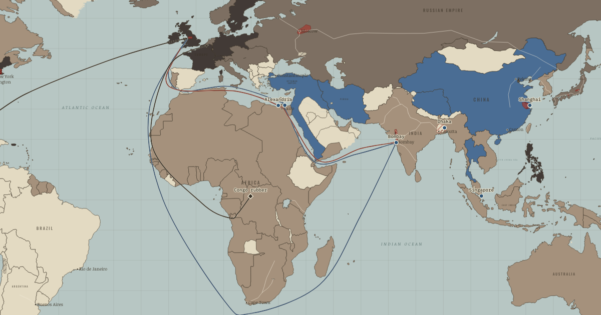
The Suez Canal opens, cutting the sea route from London to Bombay by about 40 per cent and making the passage to Asia a steamship route.
17 NOVEMBER 1869 · THE INDUSTRIAL REVOLUTION, 1750–1914 These maps are reconstructed from published sources · Bain’s railway map of South Africa,1890s, and historical route evidence · Atack: nineteenth-century US canals, March2017 · Atack: historical US railroads1826–1911, revised2023 · Bartholomew: Literary & Historical Atlas of America,1911 · Bartholomew: Literary and Historical Atlas of Asia,1912 · Cliopatria v 0.2.1 · Royal Museum for Central Africa: Matadi–Léopoldville opening1898 · Dakar–SaintLouis railway: historical construction record · Imperial Gazetteer of India,Atlas1909: railways · Nazrin Shah: tin’s shift from Larut to Kinta1850–1900 · Natural Earth physical geography · South African History Online: Witwatersrand goldfield · Maps of History: industrial geography reconstruction record · Uganda Railways Corporation: original railway history · UNESCO: Sites of Japan’s Meiji Industrial Revolution · UNESCO: Humberstone and Santa Laura saltpeter works · UNESCO: Tomioka Silk Mill and related sites
Source details University of Minnesota historical map; southern routes. Northern routes use the existing independently authored named-place reconstruction; detailed period vectors were unavailable.. Historical map geographic facts; original scan not republished Jeremy Atack, Vanderbilt University. Shapefile metadata explicitly grants free use; source segment dates and identities retained.. Author metadata grants free use by anyone with source acknowledgement Jeremy Atack, Vanderbilt University. Shapefile metadata explicitly grants free use; source segment dates and identities retained.. Author metadata grants free use by anyone with source acknowledgement John George Bartholomew,1911; economic maps and named transport routes. Original cartographer died1920; independent geographic reconstruction.. Public-domain original historical cartography; geographic facts independently reconstructed John George Bartholomew,1912; economic mapspp40–41,72–73, products54–55; regional railway maps and route gazetteer. Original author died1920. Only geographic facts independently reconstructed; ebook text/brand not republished.. Public-domain original historical cartography; geographic facts independently reconstructed Cliopatria contributors / Seshat Global History Databank. Selected, combined, reprojected and corrected by Maps of History as described per layer.. CC BY4.0 Museum photographic primary record of the July1898 railway inauguration. Named route reconstructed through the historical Thysville sector; no photograph or artwork copied.. Historical geographic evidence; independent route reconstruction Document-based chronology: Dakar–Rufisque opened1883; completed to SaintLouis1885. Named route geography independently reconstructed through Thiès.. Historical geographic evidence; independent route reconstruction Digital South Asia Library, University of Chicago; maps22–25 and provincial maps. Later plates locate routes, not early opening dates.. Public-domain historical government atlas; geographic facts independently reconstructed Historical research confirms Larut and Kinta district locations and period; contemporary atlas supplies the geographic setting.. Historical geographic facts used for independent reconstruction; no source artwork copied Made with Natural Earth; present coastlines support physical clipping, not historical political boundaries.. Public domain Named MainReef mining corridor Randfontein–Springs/Nigel; independent regional geography, not mine-lease boundaries.. Historical geographic facts used for independent reconstruction; no source artwork copied Named districts and route stations from the linked published atlases. District perimeters are interpretive economic regions, not sovereign borders or parcel-level industrial land use.. Original independent thematic reconstructions; source artwork not embedded Railway operator historical record: Mombasa1896 to Kisumu1901. Independent named-station route reconstruction.. Historical geographic facts used for independent reconstruction; no source artwork copied UNESCO World Heritage Centre; named industrial locations and period evidence. The atlas district is not a copy of the modern UNESCO property boundary.. Factual geographic evidence; property artwork not redistributed UNESCO World Heritage Centre; named industrial locations and period evidence. The atlas district is not a copy of the modern UNESCO property boundary.. Factual geographic evidence; property artwork not redistributed UNESCO World Heritage Centre; named industrial locations and period evidence. The atlas district is not a copy of the modern UNESCO property boundary.. Factual geographic evidence; property artwork not redistributed Country fills apply the existing educational industrialisation stages to dated published polities. They do not imply that development was uniform throughout each empire. Economic districts represent thematic regions. Source dates and reconstruction methods are recorded separately.
reconstruction: 1861.3 · reconstruction: 1869.9 · reconstruction: 1890 · reconstruction: 1910.7 · reconstruction: Named district within chapter chronology · vector: 1815–1937 · vector: 1840–1978 · vector: 1848–1935 · vector: 1861 · vector: 1864–1921 · vector: 1865–1914 · vector: 1865–1915 · vector: 1866–2023 · vector: 1869 · vector: 1871–1914 · vector: 1873–1913 · vector: 1877–1935 · vector: 1877–2023 · vector: 1885–1925 · vector: 1890 · vector: 1890–1914 · vector: 1890–2023 · vector: 1895–1917 · vector: 1895–1941 · vector: 1895–1978 · vector: 1898–1914 · vector: 1898–2023 · vector: 1900–1986 · vector: 1905–1914 · vector: 1905–1915 · vector: 1905–1921 · vector: 1905–1923 · vector: 1905–1925 · vector: 1905–1927 · vector: 1905–1928 · vector: 1905–1942 · vector: 1905–1949 · vector: 1905–1999 · vector: 1908–1913 · vector: 1908–1916 · vector: 1908–1931 · vector: 1908–1935 · vector: 1910 · vector: 1911–1913 · vector: 1911–1914 · vector: 1911–1915 · vector: 1911–1925 · vector: 1911–1929 · vector: 1912–1913 · vector: 1912–1914 · vector: 1912–1919 · vector: 1912–1955 · vector: 1913 · vector: 1913–1913 · vector: 1913–1914 · vector: 1913–1915 · vector: 1913–1918 · vector: 1913–1919 · vector: Erie Canal completed1825 / source2017
Layer records and reconstruction methods
The moment in context A voyage between London and Bombay once required a long passage around Africa. The opening of the Suez Canal on 17 November 1869 reduced the route from about 10,700 to 6,300 nautical miles. Steam made the shorter route practical: from the 1860s iron steamships with compound engines used steam twice to save coal, and coaling stations such as Singapore supplied them along the way. Ships could make long journeys more cheaply and reliably.
From Great Divergence and global trade , chapter 11 of The Industrial Revolution, 1750–1914 (1913).
Teach this in 5 minutes Why it happened — Steam and cable shrank distance. Distance had once shielded local producers from some competition because moving goods and news was expensive. Steam and cable reduced that…The turn — The Suez Canal, 17 November 1869. The canal opened on 17 November 1869 and shortened the voyage between Britain and India by about 40 per cent. Its narrow passage and the Red Sea…What it changed — Nationalism grows from economic grievance. The loss of Indian wealth became an argument for political change. Dadabhai Naoroji charged that British rule drained the country, and the Indian…Then ask the room: Was the impoverishment of regions such as India the result of industrial competition or of imperial rule? The argued answer is on the chapter page →
The atlas that shows it
THE FREE PRINTABLE STUDY GUIDE
Get the printable study guide for The Industrial Revolution free. I’ll send you a few short letters, then one when a new atlas opens. That’s all. — Paul
NO TRACKING · YOUR ADDRESS IS USED FOR THE DISPATCH AND NOTHING ELSE ·
UNSUBSCRIBE ANYTIME