MAPS OF HISTORY · ON THIS DAY · NOVEMBER 9 · Kristallnacht (1938)ON THIS DAY · 9 NOVEMBER 1938
Kristallnacht
Kristallnacht: synagogues burn across Germany while police watch. Fifty-one years later to the day, the Berlin Wall falls.
9 NOVEMBER 1938 · THE WAR ROOM — WW2, 1936–1945 These maps are reconstructed from published sources · Allied governments — zones of occupation and administration of Greater Berlin, 26 July 1945 · Cliopatria v0.2.1 — dated political boundaries · Regional history institute — Italian annexations of1941, Fiume province and Krk · Regional history institute — Morgan Line and Pola enclave,1945–1947 · IGM Fiume, 1:25,000, sheet53B II SE — boundary established in1924 · Natural Earth — physical reference geography · Yugoslavia (1929–1939) location map — international frontier and Adriatic coast · Treaty of Rome (1924), division of Fiume and west-bank boundary · National Museum of Contemporary History of Slovenia — Allied/Yugoslav presence and Morgan demarcation
Source details Allied governments, 1945 protocol. Historical administrative facts consulted Cliopatria contributors / Seshat Global History Databank. CC BY4.0 · Dated polity and constituent territory selections; campaign-dependent occupation overlays reconstructed separately. Regional history institute — Italian annexations of1941, Fiume province and Krk. Historical geographic facts consulted; source prose and artwork not republished Istituto regionale per la storia della Resistenza e dell’Età contemporanea nel Friuli Venezia Giulia. Independent geographic-fact reconstruction; original artwork not distributed Istituto Geografico Militare, Fiume (printed1946; 1927 survey with1931–1940 updates), reproduced by Istituto regionale per la storia della Resistenza e dell’Età contemporanea nel Friuli Venezia Giulia. Independent reconstruction from graticule coordinates and boundary observations; archive page reserves artwork rights.. Geographical-fact reconstruction; original archive artwork not distributed Natural Earth. Public domain NordNordWest/Wikipedia. Converted from the published SVG to WGS84; eastern Italian regional territory extracted. Source cites Velhagen & Klasings Großer Volksatlas (1938).. CC BY-SA 3.0 Germany 1924 agreement interpreted alongside the regional history institute and City of Rijeka’s explanation of the Donja/Gornja Drenova division.. Historical geographic facts; citation only National Museum of Contemporary History of Slovenia — Allied/Yugoslav presence and Morgan demarcation. Historical geographic facts consulted; source prose and artwork not republished The earliest separately published East and West German outlines serve as regional geometry proxies for the German occupation zones. Berlin sector detail lies beyond the source’s resolution.
The June 1945 Morgan military demarcation and the separate Pola enclave are reconstructed from the published map. They show occupation areas, not a settlement of sovereignty.
The dates of published political outlines retain the resolution available in their sources. Military fronts and operational perimeters have their own source and method records.
proxy: 1949–1952 earliest distinct published EastGerman outline;1945 occupation reference · proxy: 1949–1952East /1950–1957West regional reference · proxy: Earliest separateBerlin enclave in1949 source;1945occupation chronology · reconstruction: 1945.75 · reconstruction: 1945–1945 · reconstruction: 1945–1957 · reconstruction: 1945–2023 · reconstruction: 1949–1952East /1950–1957West regional reference · vector: 1912–1955 · vector: 1936–1945 · vector: 1938–1972 · vector: 1939–2023 · vector: 1942–1945 · vector: 1943–1945 · vector: 1943–1946 · vector: 1944–1945 · vector: 1945–1945 · vector: 1945–2023
Layer records and reconstruction methods
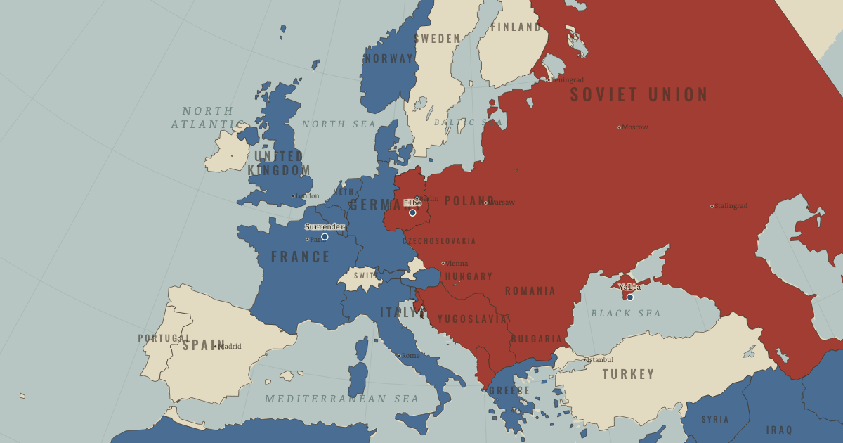
The moment in context What could the victors agree to do with the countries their armies occupied? At Yalta and Potsdam, the former allies negotiated over a map on which power was already unevenly distributed. Soviet forces held much of Eastern Europe, and Western forces held the west. Agreements mattered, but an occupying power could influence how promises were enforced. Germany’s occupation zones later became two states; Korea was divided at the 38th parallel.
From Aftermath of WW2 , chapter 15 of The War Room — WW2, 1936–1945 (OCT 1945).
Teach this in 5 minutes Why it happened — Armies and the peace. The negotiators at Yalta and Potsdam did not begin with a blank map. Armies already occupied much of Europe, giving their governments the power to…The turn — The handshake that became a border. On 25 April 1945, soldiers of the two victorious armies met at Torgau and posed on a damaged bridge. Their countries had fought together against…What it changed — The long peace — under a mushroom cloud. Since 1945 there has been no direct great-power war. Historians debate how much deterrence, exhaustion, institutions and luck contributed to that…Then ask the room: Was the Second World War “one war”? Argue both sides using what you’ve seen on this map. The argued answer is on the chapter page →
The atlas that shows it
THE FREE PRINTABLE STUDY GUIDE
Get the printable study guide for WW2 free. I’ll send you a few short letters, then one when a new atlas opens. That’s all. — Paul
NO TRACKING · YOUR ADDRESS IS USED FOR THE DISPATCH AND NOTHING ELSE ·
UNSUBSCRIBE ANYTIME