MAPS OF HISTORY · ON THIS DAY · SEPTEMBER 20 · Battle of Chickamauga (1863)ON THIS DAY · 20 SEPTEMBER 1863
Battle of Chickamauga
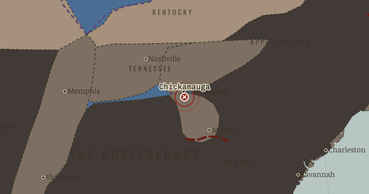
19–20 Sep 1863 — In the north-Georgia woods, Bragg breaks the Union line in the bloodiest western battle of the war, which leaves 34,000 casualties. George Thomas’ stand earns him the name “the Rock of Chickamauga” and saves the Union army, though it must retreat to Chattanooga, where it comes under siege.
20 SEPTEMBER 1863 · THE AMERICAN CIVIL WAR, 1840–1877 These maps are reconstructed from published sources · US Military Academy: Principal Campaigns of the War · US Military Academy: Strategic Situation at the End of the Campaign, 27 February 1862 · US Military Academy: Southeastern United States, 1861 · US Military Academy: Chattanooga and Vicinity, 1863 – Movements Since 24 June · US Military Academy: Chattanooga and Vicinity, 1863 – Opening the Gateway, 30 September -17 October · US Military Academy: Grant’s Plan for the 1864 Campaign · US Military Academy: Sherman’s Turning Movement, 26 August 1864 · US Military Academy: Principal Federal Movements, November 1864 – April 1865 · US Military Academy: Capture of Weldon Railroad, 18 August 1864 · National Park Service: Port Royal and the Sea Islands · Cliopatria v 0.2.1 · Fort Donelson National Battlefield · Newberry Atlas of Historical County Boundaries: historical states and territories · Maps of History: Civil War source decisions
Source details US Military Academy Department of History; selected geographic facts reconstructed independently, original chart retained outside distributed files.. Geographic evidence only. Source atlas index requests reprint permission; original artwork not redistributed. US Military Academy Department of History; selected geographic facts reconstructed independently, original chart retained outside distributed files.. Geographic evidence only. Source atlas index requests reprint permission; original artwork not redistributed. US Military Academy Department of History; selected geographic facts reconstructed independently, original chart retained outside distributed files.. Geographic evidence only. Source atlas index requests reprint permission; original artwork not redistributed. US Military Academy Department of History; selected geographic facts reconstructed independently, original chart retained outside distributed files.. Geographic evidence only. Source atlas index requests reprint permission; original artwork not redistributed. US Military Academy Department of History; selected geographic facts reconstructed independently, original chart retained outside distributed files.. Geographic evidence only. Source atlas index requests reprint permission; original artwork not redistributed. US Military Academy Department of History; selected geographic facts reconstructed independently, original chart retained outside distributed files.. Geographic evidence only. Source atlas index requests reprint permission; original artwork not redistributed. US Military Academy Department of History; selected geographic facts reconstructed independently, original chart retained outside distributed files.. Geographic evidence only. Source atlas index requests reprint permission; original artwork not redistributed. US Military Academy Department of History; selected geographic facts reconstructed independently, original chart retained outside distributed files.. Geographic evidence only. Source atlas index requests reprint permission; original artwork not redistributed. US Military Academy Department of History; selected geographic facts reconstructed independently, original chart retained outside distributed files.. Geographic evidence only. Source atlas index requests reprint permission; original artwork not redistributed. National Park Service; November1861 Port Royal occupation. The early coastline layer is date-specific, not the entire1862 coastal gain.. US government historical geographic evidence Cliopatria contributors / Seshat Global History Databank. Selected, combined, reprojected and corrected by Maps of History as described per layer.. CC BY4.0 National Park Service; February1862 river forts and Nashville campaign.. US government historical geographic evidence The Newberry Library, Atlas of Historical County Boundaries. State/territory records unioned for the displayed date; disputed/joint territories excluded from exclusive US sovereignty.. Publisher permits commercial and noncommercial lawful reuse without fees; current terms supersede obsolete NC notice in archive Source-native legal boundaries, annual military control and independently reconstructed campaign sectors are kept separate. Region connectors and corridor widths are interpretive.. Original historical reconstruction with attributed evidence Legal US boundaries come from dated Newberry records. Secession and military control use separate source layers, while campaign corridors are educational geographic reconstructions rather than surveyed continuous fronts.
reconstruction: 1845 · reconstruction: 1861 · reconstruction: 1861-04-13 · reconstruction: 1861-07-21 · reconstruction: 1862-02-28 · reconstruction: 1862-06-08 · reconstruction: 1863 · reconstruction: 1863-07-10 · reconstruction: 1863-11-26 · reconstruction: 1864 · reconstruction: 1864-09-03 · reconstruction: August1864 Richmond/Petersburg siege sectors · reconstruction: Jonesboro/Lovejoy sector after Atlanta falls,September1864 · vector: 1860 state-interface reference · vector: us-e24e487b916d
Layer records and reconstruction methods
The moment in context The Confederacy had a way to meet a threat in one theater: send troops from another. Longstreet’s corps had traveled from Virginia to help win at Chickamauga. In 1864 Grant tried to make that choice harder. Union armies would advance in the same weeks, so that Confederate commanders had to face dangers in several places at once. Even a secondary drive that failed to reach its objective could occupy troops needed elsewhere.
From Overland and Atlanta campaigns , chapter 9 of The American Civil War, 1840–1877 (JUL 1864).
The place: Battle of Chickamauga — map and full story →
Teach this in 5 minutes Why it happened — Pressure on several fronts. Longstreet’s journey from Virginia to Chickamauga shows what Confederate railroads could accomplish: troops released from one theater could help win…The turn — South at Brock Road, 7 May 1864. After two days in the burning scrub of the Wilderness, Lee could arguably claim a tactical success. The Army of the Potomac had learned to expect…What it changed — Petersburg and the railroads. Lee had to defend roughly thirty miles of works around Petersburg and Richmond with an army that could scarcely man them. For nine months Grant…Then ask the room: Was Grant a “butcher”? What evidence would help us judge? The argued answer is on the chapter page →
The atlas that shows it
THE FREE PRINTABLE STUDY GUIDE
Get the printable study guide for The American Civil War free. I’ll send you a few short letters, then one when a new atlas opens. That’s all. — Paul
NO TRACKING · YOUR ADDRESS IS USED FOR THE DISPATCH AND NOTHING ELSE ·
UNSUBSCRIBE ANYTIME