MAPS OF HISTORY · ON THIS DAY · AUGUST 29 · First Soviet atomic bomb test (1949)ON THIS DAY · 29 AUGUST 1949
First Soviet atomic bomb test
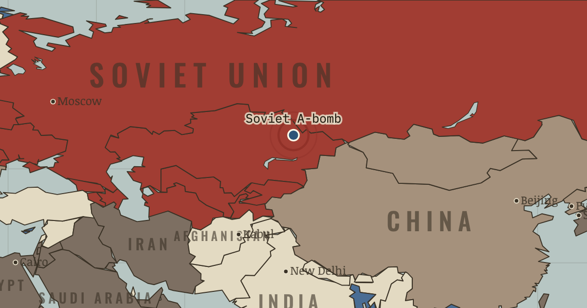
29 Aug 1949 — At Semipalatinsk, the USSR tests an atomic bomb years sooner than Western estimates had predicted. The United States has held its monopoly for four years and twenty days, counting from Nagasaki; now it is over.
29 AUGUST 1949 · THE COLD WAR, 1945–1991 These maps are reconstructed from published sources · The Berlin Airlift, 1948–1949 · North Atlantic Treaty: Algerian departments cease to apply from 3 July 1962 · Berlin’s four-power status and its termination · The rise and fall of the Berlin Wall · The Chinese Revolution of 1949 · Cliopatria v0.2.1 historical polities · Decolonization of Asia and Africa, 1945–1960 · NATO membership chronology · Natural Earth v5.1.2 country geography · Natural Earth administrative references · The collapse of the Soviet Union · South Yemen: independence and alignment chronology · South Yemen: Soviet relationship, 1971 intelligence estimate
Source details US government historical publication. Historical facts cited; no source artwork or prose reproduced NATO, treaty footnote 2. Historical treaty facts cited; no artwork or prose reproduced US government historical publication. Historical facts cited; no source artwork or prose reproduced US government historical publication. Historical facts cited; no source artwork or prose reproduced US Department of State, Office of the Historian. US government publication Cliopatria contributors / Seshat Global History Databank. CC BY 4.0 · Selected dated records; documented component selection, unions and shared-edge extraction. US Department of State, Office of the Historian. US government publication NATO. Historical facts cited; no artwork or prose reproduced Natural Earth contributors. Public domain · Full source components and holes retained; documented historical unions and repairs. Natural Earth contributors. Public domain US Department of State, Office of the Historian. US government publication US Department of State. US government historical publication US Department of State, FRUS 1969–1976, volume XXIV, document 182. US government historical publication This political-alignment geography uses national and administrative extents; it does not map every military front. Modern-reference perimeters are explicitly recorded where no more suitable reviewed historical geometry was adopted. All source parts and holes are retained.
The Soviet, Yugoslav, Czechoslovak, Sudanese and other historical unions remove later internal borders. Occupation and armistice lines retain their separate meanings.
South Yemen uses the 1969 source as a geographic proxy for earlier Aden/protectorates. The boundaries and status of individual protectorates are not resolved at this scale.
Morocco uses the nearest independent 1956 outer perimeter. The separate French/Spanish protectorate boundary lies outside this political-alignment layer, and Cape Juby remains in the Spanish source footprint until 1958.
Dated assignments correct omissions across the legacy views: independent Algeria is non-aligned after July 1962; Greece and Turkey join NATO in 1952, and Spain in 1982. South Yemen is separate from North Yemen, with British administration before late 1967 and the Soviet-aligned Marxist government after 1969.
The narrative date for the chapter is 1949.78; the displayed source state is the named w49 timeline reference. Each layer records its date-specific source intervals and nearest-date choices.
proxy: 1945–1990, later municipal exterior reference · proxy: Natural Earth v5.1.2 contemporary reference · proxy: Pre-1963 Netherlands New Guinea; later provincial reference · reconstruction: 1945–1950 · reconstruction: 1945–1958 · reconstruction: 1945–1960 · reconstruction: 1945–1962 · reconstruction: 1945–1991 · reconstruction: 1945–1991 geographic union · reconstruction: 1949–1952 · reconstruction: 1950–1957 · reconstruction: Before May 1963 · reconstruction: Postwar Yugoslav reference · reconstruction: Pre-1963 North Borneo; later coast/reference exterior · vector: 1936–1986 · vector: 1945–1957 · vector: 1946–1946 · vector: 1948–1949 · vector: 1948–1952 · vector: 1948–1962 · vector: 1949–1952 · vector: 1956–1957 · vector: 1958–1960 · vector: 1969–1986
Layer records and reconstruction methods
The moment in context The Soviet explosion at Semipalatinsk ended an advantage the United States had possessed since 1945. Klaus Fuchs had passed genuine Los Alamos designs to Moscow, shortening the route to a plutonium weapon. Yet knowing how to design a bomb was only part of the task. The USSR had to mine uranium, build reactors and create a nuclear industry under enormous strain before it could test one.
From Soviet atomic bomb and Mao’s victory , chapter 3 of The Cold War, 1945–1991 (OCT 1949).
The place: First Soviet atomic bomb test — map and full story →
Teach this in 5 minutes Why it happened — Why the Nationalists lost. In 1946 Chiang’s Nationalists appeared to hold the stronger hand: they had the major cities, American equipment and, by one estimate, three times…The turn — Semipalatinsk, 29 August 1949. No border moved when the bomb exploded at Semipalatinsk. What changed was the American monopoly. The United States retained a large advantage, but a…What it changed — The arms race accelerates. Truman ordered work on a hydrogen bomb in January 1950, despite the objections of Oppenheimer’s advisory committee. The United States tested one in…Then ask the room: “Who lost China?” convulsed American politics for a decade. Was it ever America’s to lose? The argued answer is on the chapter page →
The atlas that shows it
THE FREE PRINTABLE STUDY GUIDE
Get the printable study guide for The Cold War free. I’ll send you a few short letters, then one when a new atlas opens. That’s all. — Paul
NO TRACKING · YOUR ADDRESS IS USED FOR THE DISPATCH AND NOTHING ELSE ·
UNSUBSCRIBE ANYTIME