MAPS OF HISTORY · ON THIS DAY · JULY 6 · Carnegie steel and the Homestead strike (1892)ON THIS DAY · 6 JULY 1892
Carnegie steel and the Homestead strike
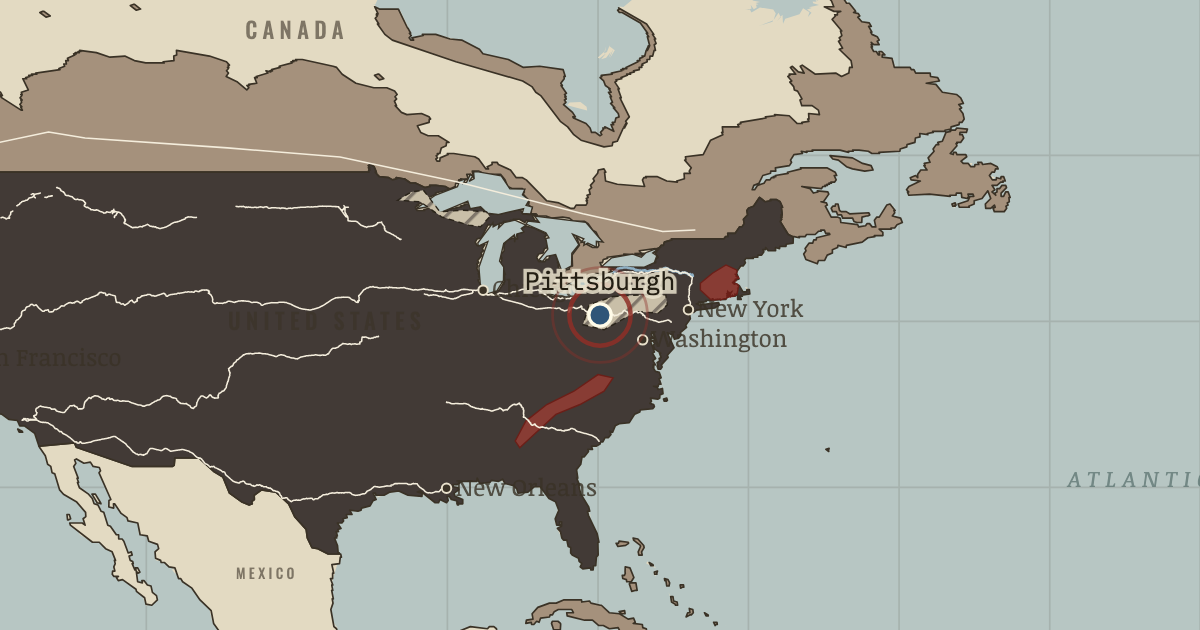
1875–1892 — Andrew Carnegie’s Bessemer steelworks operate at Braddock and Homestead. On 6 Jul 1892, a gun battle between strikers and Pinkerton guards kills seven workers and three guards. The union is broken.
6 JULY 1892 · THE INDUSTRIAL REVOLUTION, 1750–1914 These maps are reconstructed from published sources · Atack: nineteenth-century US canals, March2017 · Atack: historical US railroads1826–1911, revised2023 · Bartholomew: Literary & Historical Atlas of America,1911 · Bartholomew: Literary and Historical Atlas of Asia,1912 · Cliopatria v 0.2.1 · Dakar–SaintLouis railway: historical construction record · Imperial Gazetteer of India,Atlas1909: railways · Nazrin Shah: tin’s shift from Larut to Kinta1850–1900 · Natural Earth physical geography · South African History Online: Witwatersrand goldfield · Maps of History: industrial geography reconstruction record · UNESCO: Sites of Japan’s Meiji Industrial Revolution · UNESCO: Humberstone and Santa Laura saltpeter works · UNESCO: Tomioka Silk Mill and related sites
Source details Jeremy Atack, Vanderbilt University. Shapefile metadata explicitly grants free use; source segment dates and identities retained.. Author metadata grants free use by anyone with source acknowledgement Jeremy Atack, Vanderbilt University. Shapefile metadata explicitly grants free use; source segment dates and identities retained.. Author metadata grants free use by anyone with source acknowledgement John George Bartholomew,1911; economic maps and named transport routes. Original cartographer died1920; independent geographic reconstruction.. Public-domain original historical cartography; geographic facts independently reconstructed John George Bartholomew,1912; economic mapspp40–41,72–73, products54–55; regional railway maps and route gazetteer. Original author died1920. Only geographic facts independently reconstructed; ebook text/brand not republished.. Public-domain original historical cartography; geographic facts independently reconstructed Cliopatria contributors / Seshat Global History Databank. Selected, combined, reprojected and corrected by Maps of History as described per layer.. CC BY4.0 Document-based chronology: Dakar–Rufisque opened1883; completed to SaintLouis1885. Named route geography independently reconstructed through Thiès.. Historical geographic evidence; independent route reconstruction Digital South Asia Library, University of Chicago; maps22–25 and provincial maps. Later plates locate routes, not early opening dates.. Public-domain historical government atlas; geographic facts independently reconstructed Historical research confirms Larut and Kinta district locations and period; contemporary atlas supplies the geographic setting.. Historical geographic facts used for independent reconstruction; no source artwork copied Made with Natural Earth; present coastlines support physical clipping, not historical political boundaries.. Public domain Named MainReef mining corridor Randfontein–Springs/Nigel; independent regional geography, not mine-lease boundaries.. Historical geographic facts used for independent reconstruction; no source artwork copied Named districts and route stations from the linked published atlases. District perimeters are interpretive economic regions, not sovereign borders or parcel-level industrial land use.. Original independent thematic reconstructions; source artwork not embedded UNESCO World Heritage Centre; named industrial locations and period evidence. The atlas district is not a copy of the modern UNESCO property boundary.. Factual geographic evidence; property artwork not redistributed UNESCO World Heritage Centre; named industrial locations and period evidence. The atlas district is not a copy of the modern UNESCO property boundary.. Factual geographic evidence; property artwork not redistributed UNESCO World Heritage Centre; named industrial locations and period evidence. The atlas district is not a copy of the modern UNESCO property boundary.. Factual geographic evidence; property artwork not redistributed Country fills apply the existing educational industrialisation stages to dated published polities. They do not imply that development was uniform throughout each empire. Economic districts represent thematic regions. Source dates and reconstruction methods are recorded separately.
reconstruction: 1861.3 · reconstruction: 1869.9 · reconstruction: 1890 · reconstruction: Named district within chapter chronology · vector: 1727–1899 · vector: 1815–1937 · vector: 1820–1899 · vector: 1822–1894 · vector: 1834–1904 · vector: 1840–1894 · vector: 1840–1904 · vector: 1840–1978 · vector: 1842–1894 · vector: 1842–1907 · vector: 1842–1912 · vector: 1848–1935 · vector: 1849–1904 · vector: 1856–1894 · vector: 1859–1894 · vector: 1860–1894 · vector: 1861 · vector: 1861–1894 · vector: 1864–1921 · vector: 1865–1914 · vector: 1865–1915 · vector: 1866–1904 · vector: 1866–2023 · vector: 1869 · vector: 1871–1914 · vector: 1873–1913 · vector: 1877–1899 · vector: 1877–1935 · vector: 1877–2023 · vector: 1880–1894 · vector: 1880–1897 · vector: 1880–1899 · vector: 1885–1894 · vector: 1885–1897 · vector: 1885–1904 · vector: 1885–1907 · vector: 1885–1910 · vector: 1885–1911 · vector: 1885–1925 · vector: 1890 · vector: 1890–1894 · vector: 1890–1897 · vector: 1890–1899 · vector: 1890–1904 · vector: 1890–1910 · vector: 1890–1911 · vector: 1890–1914 · vector: 1890–2023 · vector: Erie Canal completed1825 / source2017
Layer records and reconstruction methods
The moment in context Long before the United States led the world in manufacturing, its cotton industry connected British machinery to the labor of enslaved people. Samuel Slater memorized Richard Arkwright's spinning machines in England and began spinning cotton in Rhode Island in 1790. In 1823 Boston merchants opened mills in the planned Massachusetts town of Lowell. They hired young women from New England farms; those women struck against wage cuts in 1834 and again in 1836.
From Industrial Revolution in America , chapter 9 of The Industrial Revolution, 1750–1914 (1890).
The place: Carnegie steel and the Homestead strike — map and full story →
Teach this in 5 minutes Why it happened — A continent of resources. Pennsylvania's coalfields and the Lake Superior iron ranges appear as hatched patches on the map; their resources fed Pittsburgh's industry. Coal,…The turn — Promontory Summit, 10 May 1869. At Promontory Summit the meeting tracks joined the Atlantic and Pacific economies. Goods, settlers and migrants could now cross in about a week…What it changed — America overtakes Britain. American steel output passed Britain's around 1886; by 1913 the United States made about a third of the world's manufactured goods. Its production…Then ask the room: Was America’s industrial success built more on its resources or on its people? The argued answer is on the chapter page →
The atlas that shows it
THE FREE PRINTABLE STUDY GUIDE
Get the printable study guide for The Industrial Revolution free. I’ll send you a few short letters, then one when a new atlas opens. That’s all. — Paul
NO TRACKING · YOUR ADDRESS IS USED FOR THE DISPATCH AND NOTHING ELSE ·
UNSUBSCRIBE ANYTIME