MAPS OF HISTORY · ON THIS DAY · MARCH 5 · Churchill’s Iron Curtain speech at Fulton (1946)ON THIS DAY · 5 MARCH 1946
Churchill’s Iron Curtain speech at Fulton
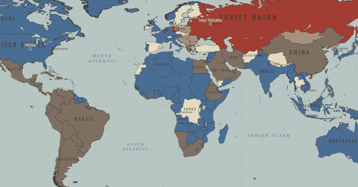
At Fulton, Missouri, Churchill declares that “an iron curtain has descended across the continent.” The Cold War has a name.
5 MARCH 1946 · THE COLD WAR, 1945–1991 These maps are reconstructed from published sources · The Berlin Airlift, 1948–1949 · North Atlantic Treaty: Algerian departments cease to apply from 3 July 1962 · Berlin’s four-power status and its termination · The rise and fall of the Berlin Wall · The Chinese Revolution of 1949 · Cliopatria v0.2.1 historical polities · Decolonization of Asia and Africa, 1945–1960 · Occupation and reconstruction of Germany, 1945–1948 · NATO membership chronology · Natural Earth v5.1.2 country geography · Natural Earth administrative references · The collapse of the Soviet Union · South Yemen: independence and alignment chronology · South Yemen: Soviet relationship, 1971 intelligence estimate
Source details US government historical publication. Historical facts cited; no source artwork or prose reproduced NATO, treaty footnote 2. Historical treaty facts cited; no artwork or prose reproduced US government historical publication. Historical facts cited; no source artwork or prose reproduced US government historical publication. Historical facts cited; no source artwork or prose reproduced US Department of State, Office of the Historian. US government publication Cliopatria contributors / Seshat Global History Databank. CC BY 4.0 · Selected dated records; documented component selection, unions and shared-edge extraction. US Department of State, Office of the Historian. US government publication National Army Museum. Historical facts cited; no source artwork or prose reproduced NATO. Historical facts cited; no artwork or prose reproduced Natural Earth contributors. Public domain · Full source components and holes retained; documented historical unions and repairs. Natural Earth contributors. Public domain US Department of State, Office of the Historian. US government publication US Department of State. US government historical publication US Department of State, FRUS 1969–1976, volume XXIV, document 182. US government historical publication This political-alignment geography uses national and administrative extents; it does not map every military front. Modern-reference perimeters are explicitly recorded where no more suitable reviewed historical geometry was adopted. All source parts and holes are retained.
The Soviet, Yugoslav, Czechoslovak, Sudanese and other historical unions remove later internal borders. Occupation and armistice lines retain their separate meanings.
German occupation zones use the 1949/1950 successor extents as a nearby-date reference. Austrian occupation uses the July 1945 agreement; the initial May deployment differed.
South Yemen uses the 1969 source as a geographic proxy for earlier Aden/protectorates. The boundaries and status of individual protectorates are not resolved at this scale.
Morocco uses the nearest independent 1956 outer perimeter. The separate French/Spanish protectorate boundary lies outside this political-alignment layer, and Cape Juby remains in the Spanish source footprint until 1958.
Dated assignments correct omissions across the legacy views: independent Algeria is non-aligned after July 1962; Greece and Turkey join NATO in 1952, and Spain in 1982. South Yemen is separate from North Yemen, with British administration before late 1967 and the Soviet-aligned Marxist government after 1969.
The narrative date for the chapter is 1946.2; the displayed source state is the named w45 timeline reference. Each layer records its date-specific source intervals and nearest-date choices.
proxy: 1945–1990, later municipal exterior reference · proxy: Natural Earth v5.1.2 contemporary reference · proxy: Pre-1963 Netherlands New Guinea; later provincial reference · reconstruction: 1945–1947 · reconstruction: 1945–1947, near-date 1949 exterior reference · reconstruction: 1945–1950 · reconstruction: 1945–1958 · reconstruction: 1945–1960 · reconstruction: 1945–1962 · reconstruction: 1945–1991 · reconstruction: 1945–1991 geographic union · reconstruction: 1949–1952 · reconstruction: 1950–1957 · reconstruction: Before May 1963 · reconstruction: Postwar Yugoslav reference · reconstruction: Pre-1963 North Borneo; later coast/reference exterior · vector: 1936–1986 · vector: 1944–1946 · vector: 1945–1957 · vector: 1946–1946 · vector: 1948–1952 · vector: 1956–1957 · vector: 1958–1960 · vector: 1969–1986
Layer records and reconstruction methods
The moment in context The postwar map began with the places armies had reached. Soviet troops occupied territory in central Europe from the east, while Western forces held ground taken from the opposite direction. Britain, France and other European powers still ruled empires across much of Asia and Africa. In Germany the victors divided both the country and its capital. Berlin lay deep inside the Soviet zone, so the Western powers could supply their sectors only by crossing territory held by the Soviet Union. Access to the city gave Moscow a way to exert pressure without a battle.
From Origins of the Cold War , chapter 1 of The Cold War, 1945–1991 (MAR 1946).
Teach this in 5 minutes Why it happened — The security dilemma — two rational fears. Soviet leaders wanted distance between Moscow and a possible invader. Two invasions through Poland in thirty years, followed by a war that killed…The turn — Moscow, 22 February 1946. A routine question about Soviet opposition to the World Bank prompted George Kennan’s roughly 5,000-word cable of 22 February 1946. He argued that…What it changed — Containment becomes policy. Aid to Greece and Turkey and the Marshall Plan gave containment political and financial force within eighteen months; NATO followed later. Kennan…Then ask the room: Was the Cold War inevitable in 1945, or did avoidable choices make it? The argued answer is on the chapter page →
The atlas that shows it
THE FREE PRINTABLE STUDY GUIDE
Get the printable study guide for The Cold War free. I’ll send you a few short letters, then one when a new atlas opens. That’s all. — Paul
NO TRACKING · YOUR ADDRESS IS USED FOR THE DISPATCH AND NOTHING ELSE ·
UNSUBSCRIBE ANYTIME