MAPS OF HISTORY · The Mongol Empire · ALL CHAPTERS · CHAPTER 1
CHAPTER 1 · THE STEPPE BEFORE 1206 · 1206
The World of the Steppe
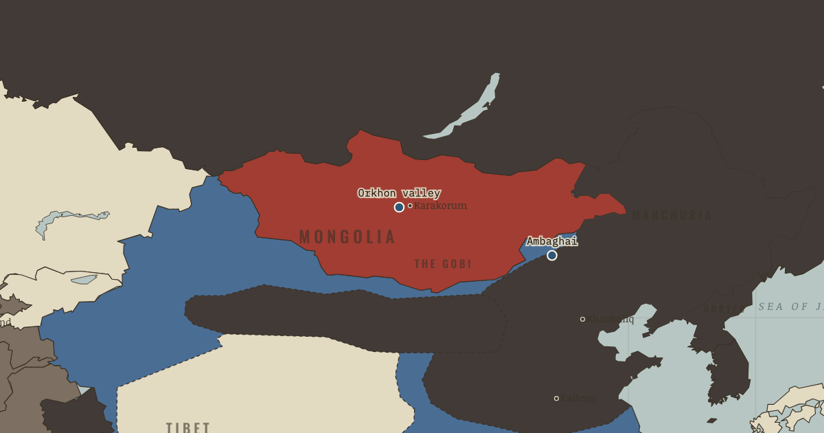
The map above is the world of 1206 — The steppe united.
BRIEF EXPLANATION — THE ESSENTIAL ARGUMENT
The Mongol empire is best understood as a political solution to a geographic opportunity. A grassland corridor runs across the center of the map from Mongolia toward Hungary, and it supported mobile herding rather than dense farming. Riding, archery and the handling of several horses at once were daily survival skills there, so steppe societies could raise experienced mounted fighters quickly and cheaply. Their durable weakness was political, because the clans and confederations of the plateau repeatedly turned their strength against one another.
The settled powers to the south had every reason to keep that weakness in place. The Jin dynasty of north China backed one steppe group against another so that no single ruler could unite the grassland against it. Temüjin grew up inside this engineered violence after his father’s murder and his family’s abandonment, and his answer was organizational rather than tactical. He set out to unite the steppe, redirect its military capacity outward, and remove the clan divisions on which Jin policy depended.
GUIDED EXPLANATION
The steppe’s military advantage began with grass, which functioned as a supply system. Herding families moved with animals that carried them and fed them, so an army drawn from those households needed little of the wagoned grain that tied settled forces to roads and depots. Children learned to ride and shoot early, and the great communal hunts trained thousands of riders to encircle prey, follow signals and hold formation. The composite bow, built from wood, horn and sinew, was short enough to draw from horseback yet powerful at a distance. Together these habits gave the plateau a standing reservoir of skilled cavalry at a cost no farming state could match.
What the grassland lacked was unity, and its neighbours worked to preserve the lack. Tatars, Kereyids, Naimans, Merkits and Mongols competed endlessly for animals, followers and revenge, while the Jin court fed those rivalries with payments and punitive expeditions. The Ambaghai episode, in which a Mongol khan was handed to the Jin and executed, became the lasting grievance that captured the whole arrangement. Temüjin’s decisive contribution was therefore institutional. He mixed men from rival clans into numbered units and made loyalty to a single commander outrank inherited kinship, so that the pasture corridor could finally carry organized force in one direction instead of dissipating it in feuds.
The two edges of the map reveal what unification would unleash. To the southeast lay wealthy, walled farming states that cavalry could raid but not capture, while to the west stretched open grazing land across which a mounted power could move at will. A united steppe could exploit the second immediately, yet it needed entirely new skills to break into the first, and that mismatch organizes the rest of the atlas. Mobility explains the long arrows of conquest that follow, and walls, rivers and seas explain where those arrows slow. Climate may have improved the pastures during these years, but it did not decide who ruled the plateau; leadership, alliance and institutions turned ecological capacity into political power.
DEEP EXPLANATION — EVIDENCE & INTERPRETATION
Pasture as a military system
Steppe mobility rested on a demanding economic tradeoff rather than on effortless supply. Several remounts let one rider change horses and travel farther than infantry, while herds moving with the army reduced its dependence on wagoned grain. That freedom carried real limits, because large concentrations of horses could exhaust grass and water quickly, especially beyond the steppe, and the ceiling helps explain both Mongol speed and later failures in wet, forested or maritime regions. Historians also weigh climate carefully. Tree-ring evidence suggests unusually favorable moisture in early thirteenth-century Mongolia, which may have expanded pasture during unification, while earlier claims of simple drought-driven conquest look less secure. Ecology created both capacity and constraint; political organization determined whether mobile households fought one another or moved together. The map records the result. Historical explanation must also keep institutions, environmental limits and decisions visible, because none of those forces worked alone.
Why divide-and-rule failed
The Jin strategy of subsidy and selective attack was rational while no confederation could dominate the plateau, since it kept frontier groups dependent and forced potential rivals to spend strength against one another. Its hidden weakness was feedback, because each intervention also created shared grievances and taught steppe leaders how settled states manipulated them. Temüjin broke the mechanism by transferring men out of clan structures and into decimal units of ten, one hundred, one thousand and ten thousand. The reform did not erase kinship, and the later reach of the yassa law code is uncertain because no complete contemporary text survives, yet the underlying pattern is clear. Once loyalty and reward flowed through the khan’s army, Jin officials could no longer isolate one tribe without confronting the whole coalition. That distinction prevents a visible event from becoming a single-cause story. Outcomes emerged through interacting political, material and human constraints over time.
New here? Chapters 1–2 of every atlas are free to sample, and the WW2 atlas is free in full. One membership opens all thirteen — the Cartographer’s Circle.
THE SITES
WHY IT HAPPENED
An ecology that manufactures cavalry. The steppe cannot feed dense populations, so it selects for mobility: five horses per rider, herds as rations on the hoof (mare’s milk, blood, dried curd), felt tents struck in an hour. A nomad army needs no supply train — its logistics graze. That single fact explains half of what follows: campaigns in winter, across deserts, at distances no settled army could contemplate.
The composite bow and the decimal habit. The recurved composite bow packed a longbow’s power into a weapon usable at full gallop, and steppe hunts — the great ring-drives called nerge — rehearsed thousands of riders in encirclement, signaling and timed movement. What Temüjin will add is organization: units of 10, 100, 1,000 and 10,000 that deliberately mix tribes, so a soldier’s loyalty runs to his unit and his khan, not his clan.
Divide-and-rule from the settled south. Jin policy treated the steppe as a fire to be managed: pay the Tatars to destroy the Mongols’ khan (see the Ambaghai marker), then arm others against the Tatars when they grew strong. It worked for a century — and it taught every steppe leader that the settled world was not a neighbor but a predator. The system’s one failure mode: a unifier it couldn’t divide.
A crisis generation. Twelfth-century chronicles describe worsening feuds and, some historians argue from tree-ring data, a cooling, drying spell squeezing the pastures. Whether or not climate lit the fuse, the social material was explosive: too many armed young men, too little order, and a code — revenge as sacred duty — that kept every wound open.
THE TURN
A khan nailed to a wooden mule, c. 1156. The Jin’s execution of Ambaghai Khan, delivered to them by Tatar treachery, is the wound the Mongol world organizes itself around for fifty years. It fixes two convictions in the steppe mind: the tribes betray each other, and the settled empire pays them to do it. Temüjin’s answer to both — dissolve the tribes, then destroy the empire — is this atlas’s whole plot.
WHAT IT CHANGED
A military revolution waiting for a manager. All the components of the world-conquering army — bow, remounts, hunt-discipline, hardiness — already exist in 1206. Nothing on this map changes technologically in the next twenty years. What changes is organization and command, which is worth reflecting on: the deadliest weapon of the thirteenth century was a personnel system.
The steppe corridor as a strategic fact. Because grass runs unbroken from Mongolia to Hungary, a power that controls pasture can project force along the whole corridor at horse-speed. Every westward arrow you will see on this map — 1223, 1237, 1241 — travels that green highway. Where the grass ends, as you will see, so does the tide.
The Jin’s playbook expires. Divide-and-rule dies the moment the steppe has one ruler; then the subsidies stop, the ledger of grievances comes due, and the wall-builders discover walls have gates and gates have traitors. Chapter 3 is that discovery.
FIELD QUESTION — Settled empires were richer, more populous and technologically ahead. Why did the steppe repeatedly produce armies they could not match?
Settled states had more people and wealth, but converting those resources into mobile armies took time, taxes and supply lines. Steppe households already possessed horses, riding skill and portable food. That gave a united confederation a high rate of mobilization at relatively low cost. The advantage was conditional, however. It depended on political unity and access to pasture. Temüjin removed the first limit in 1206; forests, wet farmland, deserts without grazing and open sea continued to impose the second.
AN INTERESTING FACT
The bow itself was slow manufacture: horn, sinew and birch laminated with fish glue and cured for a year or more, so every rider carried a small workshop’s patience on his back. Fittingly, the oldest surviving monument in the Mongolian script — the “Genghis Stone,” carved around 1225 and kept today in the Hermitage — commemorates not a conquest but a shot: the khan’s nephew Yisüngge putting an arrow out to 335 alds, roughly half a kilometer. The distance may be flattered; the priorities are not — a world empire’s first stone inscription is an archery scorecard.
THE DISPATCH
One short letter when a new atlas opens — and the printable study guide for The Mongol Empire is yours now, free.
NO TRACKING · YOUR ADDRESS IS USED FOR THE DISPATCH AND NOTHING ELSE · UNSUBSCRIBE ANYTIME